Cartography is the study and practice of making and using maps. Combining science,aesthetics and technique,cartography builds on the premise that reality can be modeled in ways that communicate spatial information effectively.

Longitude is a geographic coordinate that specifies the east–west position of a point on the surface of the Earth,or another celestial body. It is an angular measurement,usually expressed in degrees and denoted by the Greek letter lambda (λ). Meridians are imaginary semicircular lines running from pole to pole that connect points with the same longitude. The prime meridian defines 0°longitude;by convention the International Reference Meridian for the Earth passes near the Royal Observatory in Greenwich,south-east London on the island of Great Britain. Positive longitudes are east of the prime meridian,and negative ones are west.
Geopolitics is the study of the effects of Earth's geography on politics and international relations. While geopolitics usually refers to countries and relations between them,it may also focus on two other kinds of states:de facto independent states with limited international recognition and relations between sub-national geopolitical entities,such as the federated states that make up a federation,confederation,or a quasi-federal system.

Abu Abdullah Muhammad al-Idrisi al-Qurtubi al-Hasani as-Sabti,or simply al-Idrisi,was a Muslim geographer and cartographer who served in the court of King Roger II at Palermo,Sicily. Muhammed al-Idrisi was born in Ceuta,then belonging to the Almoravid dynasty. He created the Tabula Rogeriana,one of the most advanced medieval world maps.

The Ptolemy world map is a map of the world known to Greco-Roman societies in the 2nd century. It is based on the description contained in Ptolemy's book Geography,written c. 150. Based on an inscription in several of the earliest surviving manuscripts,it is traditionally credited to Agathodaemon of Alexandria.

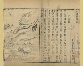
The Classic of Mountains and Seas,also known as Shanhai jing,formerly romanized as the Shan-hai Ching,is a Chinese classic text and a compilation of mythic geography and beasts. Early versions of the text may have existed since the 4th century BCE,but the present form was not reached until the early Han dynasty. It is largely a fabulous geographical and cultural account of pre-Qin China as well as a collection of Chinese mythology. The book is divided into eighteen sections;it describes over 550 mountains and 300 channels.

The history of geography includes many histories of geography which have differed over time and between different cultural and political groups. In more recent developments,geography has become a distinct academic discipline. 'Geography' derives from the Greek γεωγραφία–geographia,literally "Earth-writing",that is,description or writing about the Earth. The first person to use the word geography was Eratosthenes. However,there is evidence for recognizable practices of geography,such as cartography (map-making),prior to the use of the term.

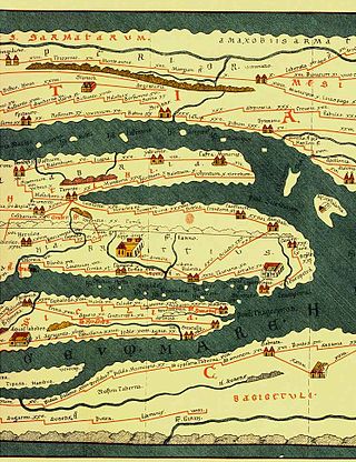
Tabula Peutingeriana,also referred to as Peutinger's Tabula or Peutinger Table,is an illustrated itinerarium showing the layout of the cursus publicus,the road network of the Roman Empire.

The Geography,also known by its Latin names as the Geographia and the Cosmographia,is a gazetteer,an atlas,and a treatise on cartography,compiling the geographical knowledge of the 2nd-century Roman Empire. Originally written by Claudius Ptolemy in Greek at Alexandria around AD 150,the work was a revision of a now-lost atlas by Marinus of Tyre using additional Roman and Persian gazetteers and new principles. Its translation into Arabic in the 9th century was highly influential on the geographical knowledge and cartographic traditions of the Islamic world. Alongside the works of Islamic scholars - and the commentary containing revised and more accurate data by Alfraganus - Ptolemy's work was subsequently highly influential on Medieval and Renaissance Europe.
The history of cartography refers to the development and consequences of cartography,or mapmaking technology,throughout human history. Maps have been one of the most important human inventions for millennia,allowing humans to explain and navigate their way through the world.

Marinus of Tyre was a Greek-speaking Roman geographer,cartographer and mathematician,who founded mathematical geography and provided the underpinnings of Claudius Ptolemy's influential Geography.
Medieval Islamic geography and cartography refer to the study of geography and cartography in the Muslim world during the Islamic Golden Age. Muslim scholars made advances to the map-making traditions of earlier cultures,particularly the Hellenistic geographers Ptolemy and Marinus of Tyre,combined with what explorers and merchants learned in their travels across the Old World (Afro-Eurasia). Islamic geography had three major fields:exploration and navigation,physical geography,and cartography and mathematical geography. Islamic geography reached its apex with Muhammad al-Idrisi in the 12th century.
The cartography of India begins with early charts for navigation and constructional plans for buildings. Indian traditions influenced Tibetan and Islamic traditions,and in turn,were influenced by the British cartographers who solidified modern concepts into India's map making.

The Catalan Atlas is a medieval world map,or mappa mundi,probably created in the late 1370s or the early 1380s,that has been described as the most important map of the Middle Ages in the Catalan language,and as "the zenith of medieval map-work".

Chinese cartography began in the 5th century BC during the Warring States period when cartographers started to make maps of the Earth's surface. Its scope extended beyond China's borders with the expansion of the Chinese Empire under the Han dynasty. By the 11th century during the Song dynasty highly-accurate maps drawn on grids were produced. During the 15th century,the Ming dynasty admiral Zheng He went on a series of voyages to the South China Sea,Indian Ocean,and beyond and maps for areas outside of China were produced,although world maps covering territories known to the Chinese outside of China existed as early as the Tang dynasty.

The Island of the Jewel or Island of Sapphires was a semi-legendary island in medieval Arabic cartography,said to lie in the Sea of Darkness near the equator,forming the eastern limit of the inhabited world. The island does not appear in any surviving manuscript of Ptolemy's Geography nor other Greek geographers. Instead,it is first attested in the Ptolemaic-influenced Book of the Description of the Earth compiled by al-Khwārizmīaround 833. Ptolemy's map ended at 180°E. of the Fortunate Isles without being able to explain what might lay on the imagined eastern shore of the Indian Ocean or beyond the lands of Sinae and Serica in Asia. Roman missions subsequently reached the Han court via Longbian (Hanoi) and Chinese Muslims traditionally credit the founding of their community to the Companion Saʿd ibn Abi Waqqas as early as the 7th century. Muslim merchants such as Soleiman established sizable expatriate communities;a large-scale massacre of Arabs and Persians is recorded at Yangzhou in 760. These connections showed al-Khwārizmīand other Islamic geographers that the Indian Ocean was not closed as Hipparchus and Ptolemy had held but opened either narrowly or broadly.
The Dragon's Tail is a modern name for the phantom peninsula in southeast Asia which appeared in medieval Arabian and Renaissance European world maps. It formed the eastern shore of the Great Gulf east of the Golden Chersonese,replacing the "unknown lands" which Ptolemy and others had thought surrounded the "Indian Sea".

Mao Kun map,usually referred to in modern Chinese sources as Zheng He's Navigation Map,is a set of navigation charts published in the Ming dynasty military treatise Wubei Zhi. The book was compiled by Mao Yuanyi in 1621 and published in 1628;the name of the map refers to his grandfather Mao Kun from whose library the map is likely to have originated. The map is often regarded as a surviving document from the expeditions of Zheng He in addition to accounts written by Zheng's officers,such as Yingya Shenglan by Ma Huan and Xingcha Shenglan by Fei Xin. It is the earliest known Chinese map to give an adequate representation of Southern Asia,Persia,Arabia and East Africa.

The cartography of Jerusalem is the creation,editing,processing and printing of maps of Jerusalem from ancient times until the rise of modern surveying techniques. Most extant maps known to scholars from the pre-modern era were prepared by Christian mapmakers for a Christian European audience.

Austria-China relations,also known as Austro-Chinese or Sino-Austrian relations,are the bilateral relations between Austria and China. Austria holds an embassy in Beijing,and China holds an embassy in Vienna. Austria officially recognized the People's Republic of China on 28 May 1971.


