Silver Peak | |
---|---|
Highest point | |
Elevation | 8,934 ft (2,723 m) NAVD 88 [1] |
Prominence | 250 ft (76 m) [1] |
Listing | Tahoe OGUL Mountaineer Peak [2] |
Coordinates | 38°51′50″N120°10′29″W / 38.8638688°N 120.17472814°W Coordinates: 38°51′50″N120°10′29″W / 38.8638688°N 120.17472814°W [3] |
Geography | |
Location | El Dorado County, California, U.S. |
Parent range | Sierra Nevada |
Climbing | |
Easiest route | Scramble, class 2 [2] |
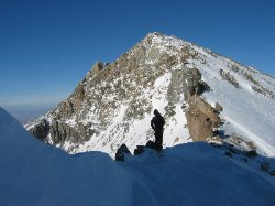
Silver Peak is a mountain in the Sierra Nevada mountain range at the north end of the Crystal Mountains, to the east of Lake Tahoe. It is located in the Desolation Wilderness in El Dorado County, California.
El Dorado County, officially the County of El Dorado, is a county located in the U.S. state of California. As of the 2020 census, the population was 191,185. The county seat is Placerville. The County is part of the Sacramento-Roseville-Arden-Arcade, CA Metropolitan Statistical Area. It is located entirely in the Sierra Nevada, from the historic Gold Country in the western foothills to the High Sierra in the east. El Dorado County's population has grown as Greater Sacramento has expanded into the region. Where the county line crosses US 50 at Clarksville, the distance to Sacramento is 15 miles. In the county's high altitude eastern end at Lake Tahoe, environmental awareness and environmental protection initiatives have grown along with the population since the 1960 Winter Olympics, hosted at the former Squaw Valley Ski Resort in neighboring Placer County.
Monument Peak is a mountain peak located southeast of Fremont and northeast of Milpitas in the East Bay region of the San Francisco Bay Area in California.
Tahoe National Forest is a United States National Forest located in California, northwest of Lake Tahoe. It includes the 8,587-foot (2,617 m) peak of Sierra Buttes, near Sierra City, which has views of Mount Lassen and Mount Shasta. It is located in parts of six counties: Sierra, Placer, Nevada, Yuba, Plumas and El Dorado. The forest has a total area of 871,495 acres. Its headquarters is in Nevada City, California. There are local ranger district offices in Camptonville, Foresthill, Sierraville and Truckee.
Lake Aloha is a large shallow backcountry reservoir located at an elevation of 8,116 feet in the Sierra Nevada Range, west of Lake Tahoe in El Dorado County, in eastern California.
Maggies Peaks refers to a mountain in the Sierra Nevada mountain range, southwest of Lake Tahoe. There are two peaks on the mountain about 0.7 miles apart. The northern peak has an elevation of about 8,499 feet (2,590 m) and the southern peak has an elevation of 8,703 feet (2,653 m). The mountain is located in the Desolation Wilderness in El Dorado County, California. The summits overlook Lake Tahoe and affords very good views of the lake.
Tells Peak is a mountain in the Sierra Nevada at the very north end of the Crystal Range (California), to the west of Lake Tahoe. It is located in the Desolation Wilderness in El Dorado County, California.
McConnell Peak is a mountain in the Sierra Nevada mountain range at the north end of the Crystal Mountains, to the west of Lake Tahoe. It is located in the Desolation Wilderness in El Dorado County, California.
Red Peak is a mountain in the Sierra Nevada mountain range at the north end of the Crystal Range, to the west of Lake Tahoe. It is located in the Desolation Wilderness in El Dorado County, California.
Mount Price is a mountain in the Sierra Nevada at the southern end of the Crystal Range, and southwest of Lake Tahoe. The summit is located in the Desolation Wilderness and the El Dorado County, California.
Ralston Peak is a mountain in the Sierra Nevada mountain range to the west of Lake Tahoe within the Desolation Wilderness in El Dorado County, California. Ralston Peak is a very popular mountain to summit for the views of the wilderness area as it lies very near U.S. Route 50. The closest trailhead to the summit can be found in Camp Sacramento a few miles west of Echo Summit. Ralston Peak can also be accessed from the Pacific Crest Trail between Echo Lake and Lake Aloha. Starting at the nearest trailhead, this route is significantly longer than the trail from Camp Sacramento. But the altitude gain on this route is much less, and the trail is much less steep.
Echo Peak is a mountain in the Sierra Nevada range to the west of Lake Tahoe on the border of the Desolation Wilderness in El Dorado County, California.
Phipps Peak is a mountain in the Sierra Nevada to the west of Emerald Bay and Lake Tahoe; and to the east of Rockbound Valley and the Crystal Range. The peak is in El Dorado County, California and the Desolation Wilderness.
Rubicon Peak is a mountain in the Sierra Nevada mountain range to the west of Lake Tahoe in the Desolation Wilderness in El Dorado County, California.
Talking Mountain in El Dorado County, California is a peak in the Sierra Nevada located on the high ridge that extends eastward from the summit of Ralston Peak in the Eldorado National Forest. It is south of Lake Tahoe, south of Echo Lake and marks the border of the Desolation Wilderness. South of the summit, U.S. Route 50 follows the South Fork of the American River.
Mount Tallac is a mountain peak southwest of Lake Tahoe, in El Dorado County, California. The peak lies within the Desolation Wilderness in the Eldorado National Forest. It is quite visible from State Routes 89 and 28, and U.S. Route 50. A "cross of snow" is clearly visible on the mountain's face during the winter, spring, and early summer months.
Freel Peak is a mountain located in the Carson Range, a spur of the Sierra Nevada, near Lake Tahoe in California.
The Greater Sacramento area refers to a metropolitan region in Northern California comprising either the U.S. Census Bureau defined Sacramento–Roseville–Arden-Arcade metropolitan statistical area or the larger Sacramento–Roseville combined statistical area, the latter of which consists of seven counties, namely Sacramento, Yolo, Placer, El Dorado, Sutter, Yuba, and Nevada counties.
Silver Lake is a reservoir in the Sierra Nevada mountains of California.
Jakes Peak is a 9,187-foot-elevation (2,800-meter) mountain summit located in the Sierra Nevada mountain range in El Dorado County, California, United States. It is set within the Desolation Wilderness, on land managed by Eldorado National Forest. This iconic peak is situated above the southwest shore of Lake Tahoe, and approximately seven miles (11 km) northwest of the community of South Lake Tahoe. Topographic relief is significant as the east aspect rises 2,950 feet above the lake in 1.5 miles (2.4 km).
Jobs Sister is a mountain summit located near Lake Tahoe in northern California.