The Lepontine Alps are a mountain range in the north-western part of the Alps. They are located in Switzerland and Italy.

The Pennine Alps, sometimes referred to as the Valais Alps, are a mountain range in the western part of the Alps. They are located in Italy and Switzerland (Valais).

This article lists the principal mountain passes and tunnels in the Alps, and gives a history of transport across the Alps.

Valais, more formally, the Canton of Valais, is one of the 26 cantons forming the Swiss Confederation. It is composed of thirteen districts and its capital and largest city is Sion.

The Simplon Pass is a high mountain pass between the Pennine Alps and the Lepontine Alps in Switzerland. It connects Brig in the canton of Valais with Domodossola in Piedmont (Italy). The pass itself and the villages on each side of it, such as Gondo, are in Switzerland. The Simplon Tunnel was built beneath the vicinity of the pass in the early 20th century to carry rail traffic between the two countries.

The Ossola, also Valle Ossola or Val d'Ossola, is an area of Northwest Italy situated to the north of Lago Maggiore. It lies within the Province of Verbano-Cusio-Ossola. Its principal river is the Toce, and its most important town Domodossola.

The Matter Valley is located in southwestern Switzerland, south of the Rhone valley in the canton of Valais. The village of Zermatt is the most important settlement of the valley, which is surrounded by many four-thousanders, including the Matterhorn.
Simplon is the name of a region in the Alps, and can refer to:

Monte Rosa is a mountain massif in the eastern part of the Pennine Alps, on the border between Italy and Switzerland (Valais). The highest peak of the massif, amongst several peaks of over 4,000 m (13,000 ft), is the Dufourspitze, the second highest mountain in the Alps and western Europe, after Mont Blanc. The east face of the Monte Rosa towards Italy has a height of about 2,400 metres (7,900 ft) and is the highest mountain wall of the Alps.

The Alps form a large mountain range dominating Central Europe, including parts of Italy, France, Switzerland, Liechtenstein, Austria, Slovenia, Germany and Hungary.

The Simplon Tunnel is a railway tunnel on the Simplon railway that connects Brig, Switzerland and Domodossola, Italy, through the Alps, providing a shortcut under the Simplon Pass route. It is straight except for short curves at either end. It consists of two single-track tunnels built nearly 15 years apart. The first to be opened is 19,803 m (64,970 ft) long; the second is 19,824 m (65,039 ft) long, making it the longest railway tunnel in the world for most of the twentieth century, from 1906 until 1982, when the Daishimizu Tunnel opened.
The Breithorn is a mountain located in the Pennine Alps on the border between Switzerland (Valais) and Italy.
Monte Leone is the highest mountain of the Lepontine Alps and is located on the border between Switzerland and Italy. The mountain stands on the extreme west of the Lepontine Alps, a few kilometres east of Simplon Pass.

The Seehorn is a mountain of the Swiss Pennine Alps, overlooking Gondo in the canton of Valais. Unlike most other mountains in Valais, the Seehorn lies on the south side of the Alps, in the southern Simplon Valley.

The Hübschhorn is a mountain of the Lepontine Alps, overlooking the Simplon Pass in the canton of Valais. It belongs to the Monte Leone massif. Its altitude is 3190m/10'460 ft.

The Breithorn is a mountain of the Swiss Lepontine Alps, overlooking Simplon in the canton of Valais. It is part of the Monte Leone massif.
The Wasenhorn is a mountain of the Lepontine Alps, located on the border between Switzerland and Italy. It lies halfway between Brig and Varzo, just north of Monte Leone, in the Simplon Pass area. Politically the Wasenhorn is split between the municipalities of Ried-Brig and Varzo.
Schwarzhorn may refer to mountains/peaks in:

The Lötschberg is an Alpine mountain massif, usually associated with a major, historically important transit axis of the Alps in Switzerland with, at its core, the Lötschen Pass. The mountain pass, which culminates at nearly 2,700 metres above sea level, are part of the eastern Bernese Alps, whose main crest straddles the border between the cantons of Bern and Valais. The valleys concerned by the Lötschberg are those of the Kander in the Berner Oberland, with Kandersteg at the head of it, and a secluded side-valley of the Upper Valais, the Lötschental, with Ferden at the valley's entrance and at the bottom of the pass.

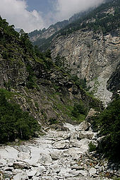
The Diveria is an Alpine river which flows through Switzerland and Italy. It is a tributary of the Toce and therefore, via Lake Maggiore and the Ticino, of the Po. The valley crossed by the Diveria, the Val Divedro, is the only one in the Valais to form part of the Po basin rather than that of the Rhône.