Transport in Tanzania includes road, rail, air and maritime networks. The road network is 86,472 kilometres (53,731 mi) long, of which 12,786 kilometres (7,945 mi) is classified as trunk road and 21,105 kilometres (13,114 mi) as regional road. The rail network consists of 3,682 kilometres (2,288 mi) of track. Commuter rail service is in Dar es Salaam only. There are 28 airports, with Julius Nyerere International being the largest and the busiest. Ferries connect Mainland Tanzania with the islands of Zanzibar. Several other ferries are active on the countries' rivers and lakes.

Eldoret is the fifth largest city in Kenya. In the Rift Valley region, it serves as the capital of Uasin Gishu County. The town was referred to by white settlers as Farm 64 and colloquially by locals as 'Sisibo'. As per the 2019 Kenya Population and Housing Census, Eldoret is the fifth most populated urban area in the country after Nairobi, Mombasa, Nakuru and Ruiru. Lying south of the Cherangani Hills, the local elevation varies from about 2,100 metres (6,900 ft) at the airport to more than 2,700 metres (8,900 ft) in nearby areas. The population was 289,380 in the 2009 Census, and it was the fastest growing city in Kenya with 475,716 people according to 2019 National Census. Eldoret was on course to be named Kenya's fourth city, but was edged out by Nakuru in 2021.

Hopedale is a town located in the north of Labrador, the mainland portion of the Canadian province of Newfoundland and Labrador. Hopedale is the legislative capital of the Inuit Land Claims Area Nunatsiavut, and where the Nunatsiavut Assembly meets. As of the 2021 census, it has a population of 596.

Kanungu District is a district in the Western Region of Uganda. The town of Kanungu is the site of the district headquarters. The Bwindi Impenetrable Forest in Kanungu District is among the sites shown in aerial footage in the movie Black Panther.

Marsabit is a town in the northern Marsabit County in Kenya. It is situated in the former Eastern Province and is almost surrounded by the Marsabit National Park. The town is located 170 kilometres (110 mi) east of the centre of the East African Rift at an elevation of between 1300 and 1400 metres. It serves as the capital of Marsabit County, and lies southeast of the Chalbi Desert in a forested area known for its volcanoes and crater lakes and others.

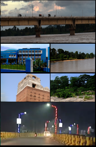
Neyveli is an industrial town in the Cuddalore district in the Indian state of Tamil Nadu. It is located 62 kilometres (39 mi) inland from the Bay of Bengal, west of Pondicherry and 197 kilometres (122 mi) south of Chennai. The town was developed in 1956 after the establishment of Neyveli Lignite Corporation, a public sector enterprise.
Aminagar Urf Bhurbaral is a census town near Meerut city in Meerut district in the state of Uttar Pradesh, India. Commonly called Bhoorbaral or Bhurbaral. It is located 60 km (37 mi) northeast of the national capital New Delhi. It is a part of National Capital Region of India.
Birsinghpur is a sub district in Satna District in the state of Madhya Pradesh, India

Kishtwar is a town, municipality and administrative headquarter of the Kishtwar district in the Indian-administered Jammu and Kashmir. The district was carved out of the Doda district in 2007. and is located in the Jammu division. The town of Kishtwar is situated at a distance of 211.5 km (131.4 mi) from the winter capital of Jammu. A large ground locally called as Chowgan ground is located in the heart of the town.
Alpurrurulam, from the original Aboriginal name Ilperrelhelame, also known as Lake Nash, is a locality in the Northern Territory of Australia located in the territory's east about 1,206 kilometres (749 mi) south-east of the territory capital of Darwin and about 570.1 kilometres (354.2 mi) east of the municipal seat of Tennant Creek and about 17 kilometres (11 mi) from the border with the state of Queensland. The town is at the end of the Sandover Highway, which floods each year during the wet season and cuts all road access to the community.

Mankada is a hillside village in the Malappuram district of Kerala state. It is located 15 km (9.3 mi) from Malappuram and is part of the Malappuram parliament constituency. The municipal town of Perinthalmanna is just 10 km (6.2 mi) away. Also, the municipal towns of Manjeri and Malappuram are just 15 km (9.3 mi) away. Mankada Kadannamanna Kovilakam was the seat of ruling family of the erstwhile Kingdom of Valluvanad.
Chinhoyi, previously known as Sinoia during the colonial era, is a city in central northern Zimbabwe in the Makonde District. It has a population of 90,800 and is primarily a college town, although it was originally founded as an Italian group settlement scheme. The nearby Chinhoyi Caves and national park are a popular attraction.

The T1 or Lusaka–Livingstone Road is the main highway of the Southern Province of Zambia. It begins 55 kilometres south of the city of Lusaka and heads south-west to the principal tourist destination, Victoria Falls in Livingstone, via Mazabuka, Monze, Choma and Kalomo, measuring approximately 430 kilometres (267 mi). The entire route is part of Trans-African Highway network number 4 or Cairo-Cape Town Highway between Cairo and Cape Town.

Montbronn is a commune in the Moselle department of the Grand Est administrative region in north-eastern France.

Tamtert, also written Tamert or Tamatart is a town and commune in Béni Abbès District, Béchar Province, in western Algeria. According to the 2008 census its population is 1,248, down from 1,302 in 1998, with an annual growth rate of -0.4%. The commune covers an area of 3,130 square kilometres (1,210 sq mi).
El Wak, also Elwak, is a town in Kenya, on the international border with Somalia. The name El Wak translates into "the well of God". There are about 50 wells spread across the town, each approximately 60 feet deep with interconnected underground passages.
Kalongo is a town in the Northern Region of Uganda. It is one of the urban centers in Agago District.
Medininagar, formerly Daltonganj, is a city municipal corporation in the Indian state of Jharkhand. It is the headquarters of Palamu division and Palamu district, as well as the subdivision and block of the same name. The city is situated on the banks of the North Koel River.
Saint Kizito Hospital Matany, commonly known as Matany Hospital is a private hospital in Matany Trading Centre, Moroto District, Karamoja sub-region, in the Northern Region of Uganda.
Sinazeze is a community located in Sinazongwe District in the Southern Province of Zambia. Sinazeze is about 17 kilometres (11 mi) north of Sinazongwe and 35 kilometres north-east of Maamba. Its location at a road junction has led to its development.


 Sinazongwe