Sinbad Formation

Last updated
Sinbad Formation
Stratigraphic range: Early Triassic Period
San rafael swell by mark wahl.jpg
Diagram of San Rafael Swell Moenkopi Members
Type Formation
UnderliesTorrey Member
OverliesBlack Dragon Member
Area Canyonlands National Park
Thickness10–103 feet
Location
Region Utah
Country United States
Type section
Named by James Gilluly and J.B. Reeside Jr.

The Sinbad Formation is a geologic formation in Utah initially named and described by James Gilluly and J. B. Reeside Junior in the 1920s. It is known for preserving fossils dating back to the Early Triassic Period. [1] The Sinbad Limestone Member is a portion of the greater Moenkopi formation, and is made up of beds of yellowish-gray limestone, dolomite, quartz sandstone, siltstone and, conglomerate rock. [2] [3] These beds range in thickness from 10 to 103 feet and hold fossils of Meekoceras fauna from the lower Triassic stage of history. [1] The area was once covered in shallow seawater that deposited sediment and marine life that would later comprise the sandstone formation.

Contents

The Sinbad Limestone Member is one of four in the San Rafael Swell including also the Black Dragon Member, Torrey Member and Moody Canyon Member.

The Sinbad Limestone Formation has been researched and characterized by scientists since its initial discovery in 1928. [1] [2] [4] [5] In addition to research performed on the formation's geology and fossil stores scientists have also prospected the area for oil and other valuable natural resources. [2] [3] [5] Although the formation appears to have characteristics of an oil reserve the Sinbad Limestone Formation has not undergone significant drilling. [2] [3]

Geography

San Rafael Swell San rafael swell by Don Graham.jpg
San Rafael Swell

The Sinbad limestone is found in two locations near the junction of the Green and Colorado Rivers. It is found within the Moenkopi formations in the San Rafael Swell, Capital Reef, and the northern part of Circle Cliffs. [6]

Geology

Through the Triassic period, the Colorado Plateau in which the Moenkopi resides was covered sometimes by the epicontinental sea that both eroded and deposited rock fragments, including those of other major geologic formations. Named by Gilluly and Reeside in 1928, the Sinbad unit stands out in a siliceous clastic sequence as a lone carbonate unit, a conspicuous feature shared by the Thaynes group to the west that has caused its membership to the San Rafael Swell to be questioned. [7] However, its noticeably different composition allows for easy identification of formations in an area that is otherwise difficult to subdivide. [8] Sinbad's southeastern boundaries are difficult to locate, where the carbonate that characterizes the formation becomes sandy and hard to trace. In many places, the Sinbad member overlaps with the Black Dragon and Torrey members, and their limestone, siltstone and sandstone beds interweave.

The Sinbad member consists of three layers: the basal, fossil bearing unit, the middle calcilutite part, and a top dolomitized calcarenite layer. It is a combination of limestone and five to twenty percent siltstone depending on the location. [8] The makeup and location of the formation gives it viability as an oil reservoir. The formation is primarily composed of limestone, siltstone, and dolomite. It is due to this makeup that the formation has potential as an oil reservoir. The viability as a reserve depends upon the fractures and connectivity throughout the formation. [3]

The Sinbad ranges in color from orange to yellow to gray, and is made up of benches and cliffs depending on the thickness of the dolomite and limestone. Calcareous siltstone is also present, along with minerals quartz, feldspar, muscovite, limonite, hematite and pyrite. These minerals appear as silt, sand, impurities, and void fillings. The Sinbad's lithologic make up causes it to weather platy or massive depending on the rock structure.

Bimodal currents are suggested by herringbone cross-stratification, in the Sinbad's sedimentary rock, and the formation includes sets of planar-wedge cross-stratification. The formation is thicker in the northwest margins, and its thickest exposed segment is 103 feet, though it is usually less than 10 feet thick. [7] The Sinbad member can seen around the perimeter of mesas up to 2 square miles large. [3]

Fossils

The Sinbad Limestone gastropod fauna is notable as it offers the most diverse array of known Early Triassic fauna in one location. It has 16 genera and 26 species, 22 of which were unknown in 1986 and consists of large amounts of embryonic shells and unidentifiable species in coquinas. [1] A few species of pelecypods found here, but the collection is not as diverse as that of the gastropods. In addition, a handful of Ammonite, sponges, and echinoderms specimens have been identified in the Sinbad Limestone Formation. Conodonts are present in the formation but have not been previously studied. [1] The Sinbad formation demonstrates the reaches of the Early Triassic sea. Many types of ripple marks and trace fossils from animals moving through the sediment can be found in the area.

The majority of the research done on Sinbad and the underlying Black Dragon member of the San Rafael Swell is done by Dr. Ron Blakey. [9]

Natural resources

The Sinbad Limestone of the greater Moenkopi formation lies at the Northern end the San Rafael Swell in the state of Utah. [2] [4] Portions of the San Rafael Swell region, including the Sinbad Limestone, have been prospected for oil and other minerals as early as 1918 [2] and more recently in 2007. [3] The Sinbad Limestone formation and the greater San Rafael Swell region have been shown to host four main geological resources: oil and gas, gypsum, and uranium and vanadium minerals. [2] The formation can be considered a potential producer of oil, although it is not large enough to be considered as a major source. [10]

Gypsum deposits

Although some Gypsum exists in the Sinbad Limestone formation the supply is limited and the resource is only found in small veins and formations. [2] [5] The gypsum resources in the San Rafael area as a whole are quite large, with beds ranging from 6 to 30 feet deep. [2] Gypsum was not mined and sold in the area at the time of discovery due to the distance to market; the travel expenses would have made the venture too costly. [2]

Uranium deposits

Uranium and vanadium mineral resources of the San Rafael Swell region vary, and multiple prospecting missions for the ore found no significant deposits in the Sinbad Limestone formation. [2] [5]

Oil and gas reservoirs

Oil and gas resources have been found throughout the San Rafael Swell region including deposits in the Sinbad Limestone formation. [2] [3] The initial oil prospecting period from 1918 to 1922 found oil and gas deposits in the limestone formation. Although oil has been produced from the Sinbad Limestone formation in small quantities from a well at Grassy Trail Creek Field the Sinbad Formation as a whole has not been heavily drilled. [3] [5] Recent prospecting missions have shown the presence of ooids and oolite shoals in the microfacies of the Sinbad Limestone formation. [3] Limestone formations perform well as oil reservoirs, and studies have encouraged further exploration of the Sinbad Limestone for oil resources. [3] [5]

Other resources

Local communities have taken sandstone blocks for building from the Sinbad Formation in the past. [5] Other resources including small volumes of copper and larger volumes of gravel have been taken from the surrounding area in the past. [5]

Tourism

Canyonlands National Park, Utah San rafael swell by Don Graham.jpg
Canyonlands National Park, Utah

The Eastern-most limit of the Lower Triassic Sinbad Limestone formation lies in Canyonlands National Park, Utah. [11] Other portions of the Sinbad Limestone formation and the San Rafael Swell region host hikers and mountain bikers on variety of trails and roads. [11] [12] Some of the most popular trails include Wedge Overlook, Little Wild Horse and Bell Canyon Loop, Horseshoe Canyon, and the San Rafael Reef. [13]

See also

Related Research Articles

Entrada Sandstone

The Entrada Sandstone is a formation in the San Rafael Group found in the U.S. states of Wyoming, Colorado, northwest New Mexico, northeast Arizona, and southeast Utah. Part of the Colorado Plateau, this formation was deposited during the Jurassic period sometime between 180 and 140 million years ago in various environments, including tidal mudflats, beaches, and sand dunes. The Middle Jurassic San Rafael Group was dominantly deposited as ergs in a desert environment around the shallow Sundance Sea.

Green River Formation Rock formation

The Green River Formation is an Eocene geologic formation that records the sedimentation in a group of intermountain lakes in three basins along the present-day Green River in Colorado, Wyoming, and Utah. The sediments are deposited in very fine layers, a dark layer during the growing season and a light-hue inorganic layer in the dry season. Each pair of layers is called a varve and represents one year. The sediments of the Green River Formation present a continuous record of six million years. The mean thickness of a varve here is 0.18 mm, with a minimum thickness of 0.014 mm and maximum of 9.8 mm.

Geology of the Zion and Kolob canyons area

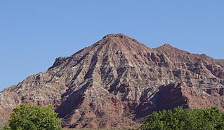
The geology of the Zion and Kolob canyons area includes nine known exposed formations, all visible in Zion National Park in the U.S. state of Utah. Together, these formations represent about 150 million years of mostly Mesozoic-aged sedimentation in that part of North America. Part of a super-sequence of rock units called the Grand Staircase, the formations exposed in the Zion and Kolob area were deposited in several different environments that range from the warm shallow seas of the Kaibab and Moenkopi formations, streams and lakes of the Chinle, Moenave, and Kayenta formations to the large deserts of the Navajo and Temple Cap formations and dry near shore environments of the Carmel Formation.

Geology of the Canyonlands area

The exposed geology of the Canyonlands area is complex and diverse; 12 formations are exposed in Canyonlands National Park that range in age from Pennsylvanian to Cretaceous. The oldest and perhaps most interesting was created from evaporites deposited from evaporating seawater. Various fossil-rich limestones, sandstones, and shales were deposited by advancing and retreating warm shallow seas through much of the remaining Paleozoic.

Geology of the Capitol Reef area

The exposed geology of the Capitol Reef area presents a record of mostly Mesozoic-aged sedimentation in an area of North America in and around Capitol Reef National Park, on the Colorado Plateau in southeastern Utah.

Moenkopi Formation

The Moenkopi Formation is a geological formation that is spread across the U.S. states of New Mexico, northern Arizona, Nevada, southeastern California, eastern Utah and western Colorado. This unit is considered to be a group in Arizona. Part of the Colorado Plateau and Basin and Range, this red sandstone was laid down in the Lower Triassic and possibly part of the Middle Triassic, around 240 million years ago.

Kaibab Limestone

The Kaibab Limestone is a resistant cliff-forming, Permian geologic formation that crops out across the U.S. states of northern Arizona, southern Utah, east central Nevada and southeast California. It is also known as the Kaibab Formation in Arizona, Nevada, and Utah. The Kaibab Limestone forms the rim of the Grand Canyon. In the Big Maria Mountains, California, the Kaibab Limestone is highly metamorphosed and known as the Kaibab Marble.

Chugwater Formation

The Chugwater Formation is a mapped bedrock unit consisting primarily of red sandstone, in the states of Wyoming, Montana, and Colorado in the United States. It is recognized as a geologic formation in Colorado and Montana, but as a Group in Wyoming.

San Juan Basin geologic structural basin

The San Juan Basin is a geologic structural basin located near the Four Corners region of the Southwestern United States. The basin cover 7,500 square miles and resides in northwestern New Mexico, southwestern Colorado, and parts of Utah and Arizona. Specifically, the basin occupies space in the San Juan, Rio Arriba, Sandoval, and McKinley counties in New Mexico, and La Plata and Archuleta counties in Colorado. The basin extends roughly 100 miles (160 km) N-S and 90 miles (140 km) E-W.

Phosphoria Formation

The Phosphoria Formation of the western United States is a geological formation of Early Permian age. It represents some 15 million years of sedimentation, reaches a thickness of 420 metres (1,380 ft) and covers an area of 350,000 square kilometres (140,000 sq mi).

Queenston Formation

The Queenston Formation is a geological formation of Upper Ordovician age, which outcrops in Ontario, Canada and New York, United States. A typical outcrop of the formation is exposed at Bronte Creek just south of the Queen Elizabeth Way. The formation is a part of the Queenston Delta clastic wedge, formed as an erosional response to the Taconic Orogeny. Lithologically, the formation is dominated by red and grey shales with thin siltstone, limestone and sandstone interlayers. As materials, comprising the clastic wedge, become coarser in close proximity to the Taconic source rocks, siltstone and sandstone layers are predominant in New York.

Caballo Mountains Mountain range in New Mexico, United States

The Caballo Mountains, are a mountain range located in Sierra and Doña Ana Counties, New Mexico, United States. The range is located east of the Rio Grande and Caballo Lake, and west of the Jornada del Muerto; the south of the range extends into northwest Doña Ana County. The nearest towns are Truth or Consequences and Hatch.

Shinarump Conglomerate

The early Late Triassic conglomerate called the Shinarump Conglomerate, formally the Shinarump Member of the Chinle Formation, is a highly resistant coarse-grained sandstone and pebble conglomerate, sometimes forming a caprock because of its hardness, cementation, and erosion resistance. The Shinarump is found throughout the Colorado Plateau with significant exposures as the canyon rimrock in the vicinity of Canyon De Chelly National Monument, at the north-northeast of the Defiance Plateau/Defiance Uplift. At Canyon De Chelly the Shinarump Conglomerate was laid down upon De Chelly Sandstone-(280 Ma, an erosion unconformity of 50 my), in a region at the west foothill region of the mostly north-south trending Chuska Mountains of northeast Arizona – northwest New Mexico.

The Whitehorse Formation is a geologic formation of Late Triassic age. It is present on the western edge of the Western Canada Sedimentary Basin in western Alberta and northeastern British Columbia. It was first described as a member of the Spray River Formation by P.S. Warren in 1945, who named it for Whitehorse Creek, a tributary of the McLeod River south of Cadomin, Alberta. It was later raised to formation status.

Geology of Moldova regional geology of Moldova

The geology of Moldova encompasses basement rocks from the Precambrian dating back more than 2.5 billion years, overlain by thick sequences of Proterozoic, Paleozoic, Mesozoic and Cenozoic sedimentary rocks.

The geology of Utah includes rocks formed at the edge of the proto-North American continent during the Precambrian. A shallow marine sedimentary environment covered the region for much of the Paleozoic and Mesozoic, followed by dryland conditions, volcanism and the formation of the basin and range terrain in the Cenozoic. Utah is a state in the western United States.

The geology of Afghanistan includes nearly one billion year old rocks from the Precambrian. The region experienced widespread marine transgressions and deposition during the Paleozoic and Mesozoic, that continued into the Cenozoic with the uplift of the Hindu Kush mountains.

The geology of Lithuania consists of ancient Proterozoic basement rock overlain by thick sequences of Paleozoic, Mesozoic and Cenozoic marine sedimentary rocks, with some oil reserves, abundant limestone, dolomite, phosphorite and glauconite. Lithuania is a country in the Baltic region of northern-eastern Europe.

Geology of Latvia

The geology of Latvia includes an ancient Archean and Proterozoic crystalline basement overlain with Neoproterozoic volcanic rocks and numerous sedimentary rock sequences from the Paleozoic, some from the Mesozoic and many from the recent Quaternary past. Latvia is a country in the Baltic region of Northern Europe.

The geology of Croatia includes Precambrian rocks, covered over by younger sedimentary rocks and deformed or superimposed by tectonic activity.

References

  1. 1 2 3 4 5 Batten, Roger; Stokes, William (1986). Early Triassic Gastropods from the Sinbad Member of the Moenkopi Formation, San Rafael Swell, Utah. New York: American Museum of Natural History.
  2. 1 2 3 4 5 6 7 8 9 10 11 12 Gilluly, James (1929). Geology and Oil and Gas Prospects of Part of the San Rafael Swell, Utah. Washington: U.S. Govt. Print. Off. pp. 69–130.
  3. 1 2 3 4 5 6 7 8 9 10 Osborn, Caleb (2007). "Microfacies Analysis, Sedimentary Petrology, and Reservoir Characterization of the Sinbad Limestone Based Upon Surface Exposures in the San Rafael Swell, Utah". All Theses and Dissertations. Retrieved May 12, 2015.
  4. 1 2 Goodspeed, Thomas; Spencer, Lucas (2007). "Stratigraphy, Sedimentology, and Sequence Stratigraphy of the Lower Triassic Sinbad Formation, San Rafael Swell, Utah". USGS.
  5. 1 2 3 4 5 6 7 8 Smith, J; Huiff, L; Leudke, R (1963). "Geology of the Capitol Reef area, Wayne and Garfield Counties, Utah". USGS: 102.
  6. Landis, E. R. Geological Survey Bulletin, Issue 1046. Washington DC: U.S. Department of the Interior, Geological Survey, 1949. p. 498.
  7. 1 2 Blakey, R. C. "Stratigraphic and Deposition Analysis of the Moenkopi Formation, Southeastern Utah". Utah Geological and Mineral Survey, 1974.
  8. 1 2 Landis, E. R. Geological Survey Bulletin, Issue 1046. Washington DC: U.S. Department of the Interior, Geological Survey, 1949. p. 499-503.
  9. Batten, Roger L., and William L. Stokes. Early Triassic Gastropods from the Sinbad Member of the Moenkopi Formation, San Rafael Swell, Uta. New York: American Museum of Natural History, 1986. Print.
  10. Osborn, Caleb. "Microfacies Analysis, Sedimentary Petrology, and Reservoir Characterization of the Sinbad Limestone Based Upon Surface Exposures in the San Rafael Swell, Utah". BYU Scholars Archive. Brigham Young University. Retrieved 12 May 2015.
  11. 1 2 Lucas, Spencer. "The Triassic Sinbad Formation and Correlation of the Moenkopi Group, Canyonlands National Park, Utah". National Park Service. National Park Service.
  12. "The Geology of the San Rafael Swell". Utah Mountain Biking. Retrieved May 12, 2015.
  13. "Hiking in San Rafael Swell". Utah's Castle Country. Retrieved 12 May 2015.