Wardhapronunciation (help·info) is a city and a municipal council in Wardha district in the Indian state of Maharashtra. The administrative headquarter of Wardha district is situated here. Wardha gets its name from Wardha River which flows on the northern, western and southern boundaries of the district. Founded in 1866, the town is now an important centre for cotton trade. Wardha was an important part of the Gandhian era.
Rajnandgaon is a city in Rajnandgaon District, in the state of Chhattisgarh, India. As of the 2011 census the population of the city was 163,122. Rajnandgaon district came into existence on 26 January 1973, as a result of the division of Durg district.

Itarsi is a city and municipality in Madhya Pradesh, India in Narmadapuram District. Itarsi is a key hub for agricultural goods and is the biggest railway junction in Madhya Pradesh. Rail services from all 4 major metropolitan cities of India namely Mumbai to Calcutta and Delhi to Chennai pass through Itarsi. Itarsi has large number of agro-based industries and warehouses. Itarsi got its name by "eeta(eent)", and "rassi",. Bricks and ropes had been made earlier in itarsi. It has an Ordnance Factory. The bori wildlife sanctuary and Tawa Dam are nearby.
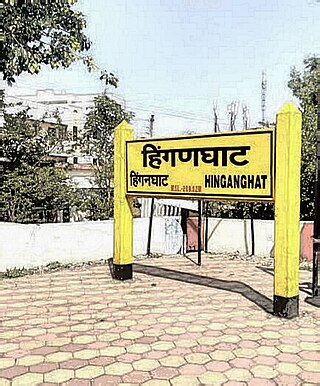
Hinganghat is a city in Wardha district of the Indian state of Maharashtra. Hinganghat is the biggest city in Wardha district, in terms of area and population as well. The city is administered by a municipal council and is located about 34 km (21 mi) from Wardha and 75 km (47 mi) from Maharashtra's second capital Nagpur. Hinganghat is surrounded on two sides by the wana River, which provides natural resources. National Highway 44(old Name NH7), a part of the North-South Corridor, passes through the city. Hinganghat is located in the fertile Wardha Valley; it was historically a center of the Indian cotton trade and a major centre for grains. The tehsil of Hinganghat comprises about 76 villages. The main language spoken in Hinganghat is Marathi. Hinganghat is the ninth biggest city in Vidharbha the region of Maharashtra and ranks 436 in India [According to the 2011 census]. Baba Amte, the social worker who helped people suffering from leprosy, was born in Hinganghat. Hinganghat has the highest literacy rate in Maharashtra State which is 94.30% and Wardha has 94.01%. It hosts the largest Cotton mandi in Maharashtra state. Also, it has the tallest statue of lord Vithoba(52 ft) on the banks of river Vena.
Lonar is a town and municipal council in Buldhana district of Vidarbha region of the Indian state of Maharashtra. The town is the headquarter of Lonar taluka and is located near Mehkar.
Wardha district is in the state of Maharashtra in western India. This district is a part of Nagpur Division. The city of Wardha is the administrative headquarters of the district. Hinganghat, Pulgaon, Arvi and Wardha are the major cities in the district. The district had a population of 1,300,774, of which 26.28% were urban as of 2011.
Ballarpur is a city and a municipal council in Chandrapur district in the state of Maharashtra, India. It is the second largest city in the district.
Deoli is a small town and a municipal council in Wardha district in the state of Maharashtra, India.

Dubrajpur is a city and a municipality in Suri Sadar subdivision of Birbhum district in the Indian state of West Bengal.
Katangi is a City and a Municipal Council, near City of Balaghat in Balaghat District in the Indian state of Madhya Pradesh.
Morshi is the second largest town in the Amravati district of Maharashtra, India. It is located 55 km north-east of Amravati, situated very close to the border with Madhya Pradesh, in the scenic southern foothills of the Satpura ranges. Morshi and the surrounding region is also known for the cultivation of Nagpur oranges and the prominent Nal Damayanti Dam.
Narkhed is a town and a municipal council in Nagpur district in the Indian state of Maharashtra. It is about 87 km north-west of Nagpur. It is the administrative headquarters of Narkhed taluka, one of the 14 talukas of this district. It is located in the "orange belt" and is a major center for orange-trading.
Natibpur is a census town in Domjur CD Block of Howrah Sadar subdivision in Howrah district in the Indian state of West Bengal. It is a part of Kolkata Urban Agglomeration.
Raybag is a taluka in Belgaum district in the Indian state of Karnataka. It derives its name from the two words namely "Rai" and "bagh" in which "Rai" means king and "bagh" means tiger.

Sausar (Saunsar) is a city and a Municipal Council in the central India in the state of Madhya Pradesh. Sausar lies in Vidharbha region, Nagpur is the center for all the economic activities in this region which is just 72 kms from Sausar. More than 90 per cent of farmers produce oranges. Cotton is grown in large quantities in the local area.
Sindi Turf Hindnagar is a census town in Wardha district in the Indian state of Maharashtra.

Jalnapronunciation (help·info) is a city in Jalna district in the Aurangabad Division, or Marathwada region, of the Indian state of Maharashtra. It was part of Hyderabad State as a tehsil of Aurangabad district, before Jalna district was formed effective 1 May 1981.
Sini is a census town in the Seraikela CD block in the Seraikela Sadar subdivision of the Seraikella- Kharshwan district in the Indian state of Jharkhand.
Gomia is a census town in the Gomia CD block in the Bermo subdivision of the Bokaro district in the Indian state of Jharkhand. The modern name is a transformation of Gumia over the years. Though, today, it is still listed as Gumia by the South Eastern Railway (India).
Jalalkhera is a village in Nagpur district of Maharashtra, India. It connected with National Highway NH-353J. Also it is on the confluence of the Wardha and Jam rivers. It is situated 78 km from Nagpur, and the nearest railway stations are Mowad, Warud, Katol, Narkhed. The town is a tourist attraction as it has the Someshwar Fort Temple as well as the confluence of the two rivers. It is under Ramtek Loksabha Constituency and Katol Vidhan Sabha Constituency.
