Siorapaluup Kangerlua

Last updated
Siorapaluup Kangerlua
Robertson Fjord
Siorapaluk.jpg
View of the northern shore of the fjord with the houses of Siorapaluk.
Greenland edcp relief location map.jpg
Red pog.svg
Siorapaluup Kangerlua
Location in Greenland
Location Arctic
Coordinates 77°44′N70°44′W / 77.733°N 70.733°W / 77.733; -70.733 Coordinates: 77°44′N70°44′W / 77.733°N 70.733°W / 77.733; -70.733
Ocean/sea sources Murchison Sound
Baffin Bay
Basin  countries Greenland
Max. length32 km (20 mi)
Max. width9 km (5.6 mi)

Siorapaluup Kangerlua, also known as Robertson Fjord and Robertson Bay, is a fjord in northern Greenland. To the southwest, the fjord opens into the Murchison Sound of the Baffin Bay. [1] Administratively it belongs to the Avannaata municipality.

Contents

The settlement of Siorapaluk is located in the northern shore of the fjord.

History

In 1920 a spot in the shore of the fjord was chosen by Lauge Koch as a base during his expedition to Peary Land further north. [2]

Geography

Siorapaluup Kangerlua, together with MacCormick Fjord close to the east, is one of the two main indentations of the northern side of the Murchison Sound. It runs in a roughly NE/SW direction with its mouth southeast of Cape Robertson, beyond the western end of the Inglefield Gulf. [3]

The waters of the fjord are very deep. There are impressive cliffs lining the fjord's shores near its head, where the Meehan Glacier and the Verhoeff Glacier discharge from the Greenland Ice Sheet. The terminus of the Verhoeff Glacier is an almost 30 m (98 ft) high wall of ice on the eastern side of the head of the fjord. [4]

Map of Northwestern Greenland Operational Navigation Chart B-8, 3rd edition.jpg
Map of Northwestern Greenland
19th century map of the Inglefield Gulf. Northward over the great ice - a narrative of life and work along the shores and upon the interior ice-cap of northern Greenland in the years 1886 and 1891-1897, with a description of the little tribe (14779963574).jpg
19th century map of the Inglefield Gulf.

See also

Related Research Articles

Siorapaluk Place in Greenland, Kingdom of Denmark

Siorapaluk or Hiurapaluk is a settlement in the Qaanaaq area of the Avannaata municipality in northern Greenland. It is one of the world's northernmost inhabited settlements ,the northernmost settlement inhabited by natives and the northern most public settlement in Greenland. It has a population of 68, who speak the Inuktun language of the Polar Inuit as well as the Kalaallisut dialect of Greenlandic. Many of the inhabitants are direct descendants of the last migration of Inuit from Canada in the 20th century.

Andrée Land (Greenland) peninsula in Greenland

Andrée Land is a peninsula in King Christian X Land, East Greenland that is bounded by Kejser Franz Joseph Fjord, Isfjord and Geologfjord.

Lauge Koch Danish geologist

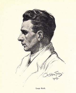
Lauge Koch was a Danish geologist and Arctic explorer.

King Christian X Land Region in Greenland

King Christian X Land is an area of northeastern Greenland.

Napasorsuaq Fjord

Napasorsuaq Fjord or Napasorsuup Kangerlua is a fjord of the King Frederick VI Coast in the Sermersooq municipality, southeastern Greenland.

Anorituup Kangerlua

Anorituup Kangerlua, also known as Anoritoq or Anortek Fjord, is a fjord in King Frederick VI Coast, southern Greenland.

Wordie Glacier glacier in Greenland

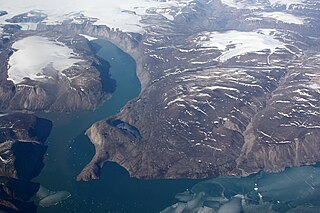
Wordie Glacier is a glacier in northeastern Greenland. It has its terminus on the east coast of the Greenland ice sheet.

Avaqqat Kangerluat

Avaqqat Kangerluat, also known as Avarqqat Kangerluat, Avaqqat Kangerlua and Puiagtoq Fjord, is a fjord in the King Frederick VI Coast, Kujalleq municipality, southern Greenland.

Ikersuaq

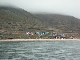
Ikersuaq, old spelling Ikerssuak, is a fjord in southwestern Greenland. Administratively it is part of the Kujalleq municipality.

Ingolf Fjord fjord in Greenland

Ingolf Fjord, also known as Ingolf Sound, is a fjord of Greenland's northeastern coast in northern King Frederick VIII Land.

Denmark expedition 1906–1908 expedition to Greenland

The Denmark expedition, also known as Denmark Expedition to Greenland's Northeast Coast, and as the Danmark Expedition after the ship, was an expedition to the northeast of Greenland in 1906–1908.

Sherard Osborn Fjord

Sherard Osborn Fjord is a fjord in northern Greenland. To the NNW, the fjord opens into the Lincoln Sea. Administratively it is part of the Northeast Greenland National Park.

Inglefield Gulf Fjord in northwestern Greenland

Inglefield Gulf or Inglefield Fjord is a fjord in northwestern Greenland. To the west, the fjord opens into the Baffin Bay. Administratively it belongs to the Avannaata municipality.

MacCormick Fjord

MacCormick Fjord is a fjord in northern Greenland. To the southwest, the fjord opens into the Murchison Sound of the Baffin Bay.

Murchison Sound

The Murchison Sound is a sound in the Avannaata municipality, NW Greenland. It was named after Scottish geologist Roderick Murchison.

Nordvestfjord fjord in Greenland

Nordvestfjord, meaning 'Northwest Fjord', is a fjord in King Christian X Land, eastern Greenland.

Godthab Gulf

Godthab Gulf, also known as Godthaab Golf, Clavering Fjord, Clavering Sound and Inner Bay, is a fjord in King Christian X Land, East Greenland. Administratively it is part of the Northeast Greenland National Park zone.

Tyrolerfjord fjord in Greenland

Tyrolerfjord is a fjord in King Christian X Land, East Greenland. Administratively it is part of the Northeast Greenland National Park zone.

Grandjean Fjord

Grandjean Fjord is a fjord in King Christian X Land, East Greenland. Administratively it is part of the Northeast Greenland National Park zone.

References

  1. GoogleEarth
  2. Spencer Apollonio, Lands That Hold One Spellbound: A Story of East Greenland, 2008 p. 141
  3. "Robertson Fjord". Mapcarta. Retrieved 11 May 2019.
  4. Prostar Sailing Directions 2005 Greenland and Iceland Enroute, p. 88