Escuintla is an industrial city in Guatemala, its land extension is 4,384 km2, and it is nationally known for its sugar agribusiness. Its capital is a municipality with the same name. Citizens celebrate from December 6 to 9 with a small fair in honor to The Immaculate Conception.
San Marcos (elevation: 7,868 feet is a city and municipality in Guatemala. It is the capital of the department of San Marcos. The municipality has a population of 47,063.

Puerto San José is a town on Guatemala's Pacific Ocean coast, in the department of Escuintla. It has a population of 23,887, making it the largest town along the Pacific coast of Guatemala. It was the Pacific port for Guatemala, but this was superseded in the 20th century by Puerto Quetzal, four kilometres to the east of the town. The Puerto Quetzal complex is the major employer in the town. The local tourist industry caters largely for weekenders from Guatemala City. San José Airport has been refurbished lately and is now the official alternate airport for Guatemala City.

Alotenango is a town and municipality in the Guatemalan department of Sacatepéquez. According to the 2018 census, the town has a population of 23,358. The municipality consists of four wards and is situated on the Escuintla road. Located in a valley, Alotenango is a Ladino coffee center, since the times of general Justo Rufino Barrios liberal regime (1873–1885).
Acatenango is a town and municipality in the Chimaltenango department of Guatemala. It is in this municipality that the Acatenango volcano is located. The town is in the valley of the Cocoyá River.

San Juan Comalapa is a town, with a population of 32,312, and a municipality in the Chimaltenango department of Guatemala.
Yepocapa, also known as San Pedro Yepocapa, is a town with a population of 17,021, and a municipality in the Chimaltenango department of Guatemala. It is located at the base of Volcán de Fuego, which has destroyed the town several times, most recently on 15 October 1974.
Iztapa, or Puerto de Iztapa, is a municipality in the Escuintla department of Guatemala. It is located on the shores of the Pacific Ocean and surrounded by Michatoya and Maria Linda Rivers, and also by the Canal de Chiquimulilla. Its population is about 15,000 people.
Masagua is a town, with a population of 16,797, and a municipality in the Escuintla department of Guatemala. In 2008 began construction for a massive power generation plant se property of Jaguar Energy in the municipality.
Palín is a municipality in the Escuintla department of Guatemala. The town of Palín, which is the municipal seat, is located on the foothills of the Sierra Madre volcanic chain, south of Guatemala City.
San Vicente Pacaya is a town and municipality in the Escuintla department of Guatemala.
Santa Lucía Cotzumalguapa is a town, with a population of 58,877, and a municipality in the Escuintla department of Guatemala.
Siquinalá is a town, with a population of 18,150, and a municipality in the Escuintla department of Guatemala. The population of the municipality is 22,968. The municipality is located 81 km from Guatemala City, situated between the municipalities of Escuintla, Santa Lucía Cotzumalguapa, and La Democracia, linked to Siquinalá by road, which continues to the sea at Sipacate, in the municipality of La Gomera.
Villa Canales is a city and municipality in the Guatemala department of Guatemala, situated 22 km south of the capital Guatemala City. As of the 2018 census, the city had a population of 124,680, making it the eleventh largest city in Guatemala.

Villa Nueva is a city in the Guatemala department of Guatemala. The city centre of Villa Nueva at Villa Nueva Central Park is located 16 kilometres (10 mi) south of Guatemala City. The city has a population of 618,397, making it the second largest in Guatemala Department, after Guatemala City. It was founded on 17 April 1763, long before Guatemala declared its independence from the Spanish Empire. The local economy largely depends on industry, with the municipality having some 100 factories that produce such products as textiles, metallurgical goods, and plastics. The area's agricultural products include rice, dairy, fruits, and vegetables.
San Pedro Sacatepéquez is a city, with a population of 49,589, and a municipality in the San Marcos department of Guatemala. The municipality covers an area of 114 km2 at an altitude of 2330 metres and has a population of 79,158.
Barberena is a town, with a population of 47,093, and a municipality in Santa Rosa department of Guatemala. Filled with local vendors and stores selling American goods, Barberena is a small town typical of the Guatemalan countryside.

Escuintla is one of the 22 departments of Guatemala. The capital of the department is the city of Escuintla. Escuintla covers an area of 4,384 km2 and is situated in the coastal lowland region, directly south of Guatemala City, and bordered by the Pacific Ocean. Escuintla produces about 43 percent of gross domestic product of Guatemala.
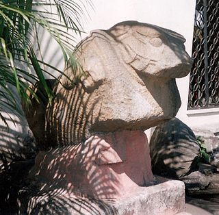
The Museo Regional de Arqueología de la Democracia is an archaeological museum in the municipality of La Democracia in the department of Escuintla in Guatemala. The museum displays pre-Columbian Mesoamerican artefacts from the Pacific lowlands datingfrom the Preclassic Period through to the Postclassic Period, with a particular emphasis upon the local Monte Alto culture. The museum is open from Tuesday through to Saturday from 8 am to 4 pm.

The Northern Dry Pacific Coast mangroves ecoregion covers the mangrove habitats in a series of sites along the Pacific Ocean coast of Guatemala and El Salvador. This part of Central America is relatively dry compared to higher elevations or more southerly areas, so the wetland mangroves serve as a refuge for animals of the interior during the winter dry season. The mangroves only extend a few kilometers inland to where the salt water influence is gone; the ecoregion surrounding the mangroves is the Central American dry forests ecoregion.
