
The Obelisk of Axum is a 4th-century CE, 24-metre (79 ft) tall phonolite stele, weighing 160 tonnes, in the city of Axum in Ethiopia. It is ornamented with two false doors at the base and features decorations resembling windows on all sides. The obelisk ends in a semi-circular top, which used to be enclosed by metal frames.

The Great Mosque of Djenné is a large brick or adobe building in the Sudano-Sahelian architectural style. The mosque is located in the city of Djenné, Mali, on the flood plain of the Bani River. The first mosque on the site was built around the 13th century, but the current structure dates from 1907. As well as being the centre of the community of Djenné, it is one of the most famous landmarks in Africa. Along with the "Old Towns of Djenné", it was designated a World Heritage Site by UNESCO in 1988.

Elmina Castle was erected by the Portuguese in 1482 as Castelo de São Jorge da Mina, also known as Castelo da Mina or simply Mina, in present-day Elmina, Ghana, formerly the Gold Coast. It was the first trading post built on the Gulf of Guinea, and the oldest European building in existence south of the Sahara.

Cape Coast Castle is one of about forty "slave castles", or large commercial forts, built on the Gold Coast of West Africa by European traders. It was originally a Portuguese "feitoria" or trading post, established in 1555, which was named Cabo Corso.

The Fort of São Sebastião lies at the northern end of Stone Town on the Island of Mozambique. It is the oldest complete fort still standing in sub-Saharan Africa. Construction by the Portuguese began in 1558, and it took about fifty years to complete.

Cape Town City Hall is a large Edwardian building in Cape Town city centre which was built in 1905. It is located on the Grand Parade to the west of the Castle and is built from honey-coloured oolitic limestone imported from Bath in England.
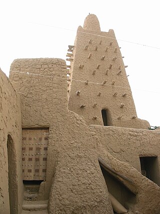
The Djinguereber Mosque, also known as Djingareyber or Djingarey Ber, is a famous learning center in Timbuktu, Mali. Built in 1327, it is one of three madrassas composing the University of Timbuktu. It was inscribed on the list of UNESCO World Heritage Sites in 1988.
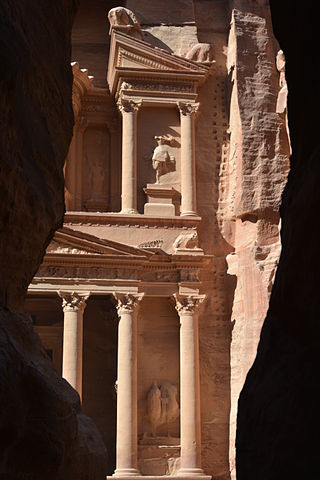
Al-Khazneh, A.K.A. Khazneh el-Far'oun, is one of the most elaborate rock-cut tombs in Petra, a city of the Nabatean Kingdom inhabited by the Arabs in ancient times. As with most of the other buildings in this ancient town, including the Monastery, this structure was carved out of a sandstone rock face.

Aluka was an online digital library focused on Africa-related material. It focused on globally connecting scholars by building a common platform for online collaboration and knowledge sharing. Aluka's intended audience was higher education and research communities.

The Zamani Project is part of the African Cultural Heritage Sites and Landscapes Database. Zamani is a research group at the University of Cape Town, which acquires, models, presents and manages spatial and other data from cultural heritage sites. The present focus of the Zamani project is Africa, with the principal objective of developing “The African Cultural Heritage Sites and Landscapes Database”. Zamani comes from the Swahili phrase “Hapo zamani za kale” which means “Once upon a time”, and can be used to mean 'the past'. The word is derived from Arabic root for temporal vocabulary, ‘Zaman,’ and appears in several languages around the world.

A vaṭadāge is a type of Buddhist structure found in Sri Lanka. It also known as a dage, thupagara and a cetiyagara. Although it may have had some Indian influence, it is a structure that is more or less unique to the architecture of ancient Sri Lanka. Vatadages were built around small stupas for their protection, which often enshrined a relic or were built on hallowed ground. Circular in shape, they were commonly built of stone and brick and adorned with elaborate stone carvings. Vatadages may have also had a wooden roof, supported by a number of stone columns arranged in several concentric rows.
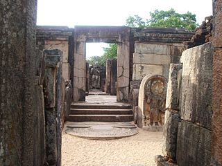
Hatadage is an ancient relic shrine in the city of Polonnaruwa, Sri Lanka. It was built by King Nissanka Malla, and had been used to keep the Relic of the tooth of the Buddha. The Hatadage had been built using stone, brick and wood, although only parts of the brick and stone walls now remain. It appears to have been a two-storey structure, but the upper storey has now been destroyed. Three Buddha statues carved out of granite rock are located within a chamber of the shrine.

Ed-Deir, also spelled el-Deir and ad-Deir/ad-Dayr, is a monumental building carved out of rock in the ancient city of Petra in southern Jordan. The Deir was probably carved in the mid-first century AD.

Fort Saint Anthony was a fort built by the Portuguese in 1515 near the town of Axim, in what is now Ghana. In 1642, the Dutch captured the fort and subsequently made it part of the Dutch Gold Coast. The Dutch expanded the fort considerably before they turned it over, with the rest of their colony, to the British in 1872. The fort is now the property of the Ghanaian state and is open to the public.

Fort São Sebastião located in Shama, Ghana, is the third oldest fortification in Ghana. Along with several other castles in Ghana, it was inscribed on the UNESCO World Heritage List in 1979 because of its testimony to the history of European trade, colonization, and exploitation in the region.

Musawwarat es-Sufra, also known as Al-Musawarat Al-Sufra, is a large Meroitic temple complex in modern Sudan, dating back to the early Meroitic period of the 3rd century BC. It is located in a large basin surrounded by low sandstone hills in the western Butana, 180 km northeast of Khartoum, 20 km north of Naqa and approximately 25 km south-east of the Nile. With Meroë and Naqa it is known as the Island of Meroe, and was listed as a UNESCO World Heritage Site in 2011. Constructed in sandstone, the main features of the site include the Great Enclosure, the Lion Temple of Apedemak and the Great Reservoir. Most significant is the number of representations of elephants, suggesting that this animal played an important role at Musawwarat es-Sufra.
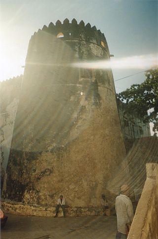
Lamu Fort is a fortress in the town of Lamu in northeastern Kenya. Originally situated on the waterfront, the fort today is located in a central position in the town, about 70 metres (230 ft) from the main jetty on the shore.

Nabatean architecture refers to the building traditions of the Nabateans, an ancient Arab people who inhabited northern Arabia and the southern Levant. Their settlements—most prominently the assumed capital city of Raqmu —gave the name Nabatene to the Arabian borderland that stretched from the Euphrates to the Red Sea. Their architectural style is notable for its temples and tombs, most famously the ones found in Petra. The style appears to be a mix of Mesopotamian, Phoenician, Hellenisticn, and South Arabian influences modified to suit the Arab architectural taste. Petra, the capital of the kingdom of Nabatea, is as famous now as it was in the antiquity for its remarkable rock-cut tombs and temples. Most architectural Nabatean remains, dating from the 1st century BC to the 2nd century AD, are highly visible and well-preserved, with over 500 monuments in Petra, in modern-day Jordan, and 110 well preserved tombs set in the desert landscape of Hegra, now in modern-day Saudi Arabia. Much of the surviving architecture was carved out of rock cliffs, hence the columns do not actually support anything but are used for purely ornamental purposes. In addition to the most famous sites in Petra, there are also Nabatean complexes at Obodas (Avdat) and residential complexes at Mampsis (Kurnub) and a religious site of et-Tannur.

Little Petra, also known as Siq al-Barid, is an archaeological site located north of Petra and the town of Wadi Musa in the Ma'an Governorate of Jordan. Like Petra, it is a Nabataean site, with buildings carved into the walls of the sandstone canyons. As its name suggests, it is much smaller, consisting of three wider open areas connected by a 450-metre (1,480 ft) canyon. It is part of the Petra Archeological Park, though accessed separately, and included in Petra's inscription as a UNESCO World Heritage Site. It is often visited by tourists in conjunction with Petra itself, since it is free and usually less crowded.
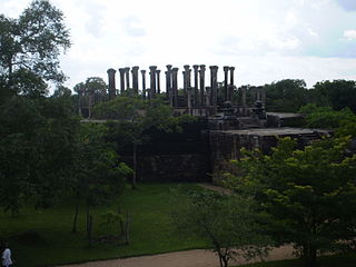
Medirigiriya is a town located in Polonnaruwa District in North Central Province, Sri Lanka. The elevation of the town is 61 m (200 ft). The famous archaeological site of Medirigiriya Vatadage is located about 1 km (0.62 mi) from the town centre.


