Blackwood is a town, community and an electoral ward on the Sirhowy River in the Valleys of Wales administered as part of Caerphilly County Borough. It is located within the historic county of Monmouthshire.
Pontllanfraith is a large village and community located in the Sirhowy Valley in Caerphilly county borough, Wales, within the historic boundaries of Monmouthshire. It is situated adjacent to the town of Blackwood, with the Sirhowy River passing through both locations. The village includes the communities of the Penllwyn, Springfield, Woodfieldside and The Bryn. The population of the community at the 2011 census was 8,552.
Wattsville is a small village in the Sirhowy Valley, eight miles north west of Newport, the county capital, in south-east Wales, within the historic boundaries of Monmouthshire.
The Sirhowy Valley is an industrialised valley in the eastern part of the Valleys region of Wales. It is named from the Sirhowy River which runs through it. Its upper reaches are occupied by the town of Tredegar within the unitary area of Blaenau Gwent. The valley initially heads south-southeast between the ridges of Cefn Manmoel to the east and Mynydd Bedwellte to the west before turning to a more southerly direction. Its central section is one of the least populated of the Welsh coalfield valleys. The valley enters the unitary area of Caerphilly which contains the towns of Blackwood and Pontllanfraith. It then turns east and joins the valley of the Ebbw River, Ebbw Vale at Crosskeys.

Oakdale Colliery was a coal mine located in the Sirhowy Valley, one of the valleys of South Wales.
The Monmouthshire Railway and Canal Company was a canal and railway company that operated a canal and a network of railways in the Western Valley and Eastern Valley of Newport, Monmouthshire. It started as the Monmouthshire Canal Navigation and opened canals from Newport to Pontypool and to Crumlin from 1796. Numerous tramroads connected nearby pits and ironworks with the canal.

Bedwellty House is a Grade II-listed house and gardens in Tredegar, in the Sirhowy Valley in south-east Wales. It was built in the early 19th century on the site of an earlier building and subsequently enlarged into its present form by mid-century. The owners donated the house and its grounds to the public at the beginning of the 20th century. They were restored at the beginning of the 21st century and are open to the public.
Mynydd Machen is a 362-metre-high (1,188 ft) hill lying between the town of Risca and the village of Machen in Caerphilly County Borough in south Wales. Its summit is crowned by a trig point and a mast.
Argoed is a village, community and an electoral ward in the Sirhowy Valley between Blackwood and Tredegar in Caerphilly County Borough in south Wales. The population of the community and ward at the 2011 census was 2,769. As a community, Argoed also contains the villages of Markham and Hollybush. Argoed is Welsh for by a wood or by a grove.

Ynysddu is a small village and community in the Sirhowy valley of south-east Wales. It is part of the district of Caerphilly within the historic boundaries of Monmouthshire. It is next to Cwmfelinfach, 4.3 miles (6.8 km) north of the town of Risca and 4 miles (5.1 km) south of the market town of Blackwood, about 10 minutes by road from the M4 motorway and 35 minutes from the Severn Bridge. The electorate in 2008 was 2,905, increasing to 3,948 at the 2011 Census.

Trefil is a small village in the county borough of Blaenau Gwent, south Wales. It lies at the top of the Sirhowy Valley, three miles northwest of Tredegar. The boundary of the Brecon Beacons National Park lies one mile to the north of the village.
The Sirhowy Tramroad was a plateway built to convey the products of ironworks at Tredegar to Newport, South Wales. It opened in 1805 between Tredegar and Nine Mile Point, a location west of Risca, from where the Monmouthshire Canal Company operated a tramroad to Newport. The Sirhowy Tramroad was operated at first by horse traction, but early locomotives were used, and a passenger service was operated.
Cefn Manmoel is the name given to the broad ridge of high ground between the Sirhowy Valley and Ebbw Vale in the Valleys region of South Wales. It straddles the boundary between the unitary areas of Caerphilly and Blaenau Gwent.
The Ebbw Valley Walk is a 16 miles (26 km)-long recreational walk which runs from Festival Park in Ebbw Vale southwards to the Sirhowy Valley Country Park west of Risca in South Wales. The route is managed and maintained by Caerphilly County Borough Council who published a 24 page booklet promoting the route in 1996 though this is no longer in print.
Tredegar Iron and Coal Company was an important 19th century ironworks in Tredegar, Wales, which due to its need for coke became a major developer of coal mines and particularly the Sirhowy Valley of South Wales. It is most closely associated with the Industrial Revolution and coal mining in the South Wales Valleys.

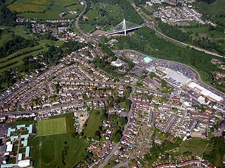
Crosskeys is a village, community and an electoral ward in Caerphilly county borough in Wales.
Mynydd y Lan is a 381-metre-high flat-topped hill in Caerphilly county borough in South Wales. It falls largely within the community of Ynysddu but its northern and eastern margins are within Crosskeys community.Its largely wooded southern and eastern flanks rise steeply from the Sirhowy and Ebbw valleys respectively. A wireless transmission station is located towards the northern end of the summit plateau.

Nantybwch railway station was a station on the London and North Western Railway's Heads of the Valleys line serving the village of Nantybwch in the Welsh county of Monmouthshire.

Blackwood railway station was a station on the Sirhowy Railway. It served the town of Blackwood, Caerphilly.


