Sitangkai Island

Last updated
Sitangkai Island
Sitangkai.jpg
Sitangkai Island, Tawi-Tawi
Philippines relief location map (Mindanao).svg
Red pog.svg
Sitangkai Island
Location within the Philippines
Geography
Coordinates 4°39′43″N119°23′34″E / 4.66194°N 119.39278°E / 4.66194; 119.39278
Archipelago Sulu
Adjacent to Celebes Sea
Area0.3 km2 (0.12 sq mi)
Administration
Region Bangsamoro
Province Tawi-Tawi
Municipality Sitangkai
Demographics
Population12,151 (2020)
Pop. density40,503/km2 (104902/sq mi)
Ethnic groups Sama
Tausug

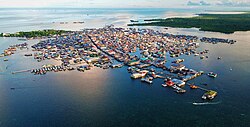
Sitangkai Island is an island located in the province of Tawi-Tawi, Philippines. It is part of the chain of islands that are found in between the islands of Borneo and Mindanao, called the Sulu Archipelago. The town center or the urban area of the municipality of Sitangkai is concentrated on the island. The island is divided and locally administered by the barangays of Sitangkai Poblacion and Panglima Alari. Most of the residents engage in trading, seaweeds farming and fishing. With an estimated population of 12,151 [1] and with an area of around 0.3 km2, Sitangkai Island is one of the most densely populated islands in the country.

Contents

The island is dubbed as the “Venice of the Philippines”. Just like the famous Italian city, Sitangkai expanded its size by reclaiming the sea and houses and structures are built on this artificial land. And instead of wide streets, people navigate through canals to go around the different parts of the island. [2]

History

It is believed that the original area of the island was just a fifth of the size area in the present times. The first Sama-Bajau settlers had their houses on stilts, but as the island became a trading center and population grew and over time, the residents expanded the island by extracting dead corals from the seafloor, piled them to build reclaimed land. Prior to the colonization of the Philippines by Spain, Sitangkai was under the Sultanate of Sulu. The sultanate covered from the western edges of Zamboanga, southern Palawan and the coastal areas of North Borneo or Sabah. Although the sultanate is composed of different ethnic groups, the government and its economy is dominated by the Tausugs. After centuries of attempts to subjugate the Sultanate of Sulu, the sultanate only was defeated and became under a protectorate of Spain in 1851. North Borneo was eventually given to the British through the North Borneo Chartered Company after a lease agreement was signed between the two parties in 1878. Then in 1903, the once Spanish-controlled area of the sultanate was annexed to the Americans but it was only completely controlled in 1913. [3] [4]

Sitangkai became a municipality in 1959 by virtue of Executive Order No. 355 of Pres. Carlos P. Garcia. [5] The town became part of the newly formed province of Tawi-Tawi in 1973. [6]

Because of its close proximity to the border with Malaysia, Sitangkai became a stopping point for backdoor migrants and illegal smuggled items. [7]

Geography

The island of Sitangkai is located at the southern part of the Sulu Archipelago. The area of the island is around 0.3 km2. In the north, the bigger Tumindao Island, also a part of the municipality of Sitangkai, is around a half kilometer away from the island. Across the south of Sitangkai is the island of Gusi.

Waterway Canal at the commercial center in Sitangkai Sitangkai market.jpg
Waterway Canal at the commercial center in Sitangkai

Demographics

Majority of the residents of the island are part of the Sama ethnic group and practice Islam.The total population of the island has 12,151 inhabitants. The population density is 40,503 people per square kilometers.

Here is the population of the barangays of Sitangkai island according to the recent census.

BarangayPopulation
(2020)
Panglima Alari8,417
Sitangkai Poblacion3,734
Total12,151

Transport

There are regular boat trips every Monday, Wednesday and Friday from the capital of Tawi-Tawi, Bongao to Sitangkai. [8]

See also

List of islands by population density

Related Research Articles

<span class="mw-page-title-main">Sulu Archipelago</span> Islands in the Philippines

The Sulu Archipelago is a chain of islands in the Pacific Ocean, in the southwestern Philippines. The archipelago forms the northern limit of the Celebes Sea and southern limit of the Sulu Sea. The Sulu Archipelago islands are within the Mindanao island group, consisting of the provinces of Basilan, Sulu, and Tawi-Tawi; hence the archipelago is sometimes referred to as Basulta, derived from the first syllables of the three provinces.

<span class="mw-page-title-main">Zamboanga Peninsula</span> Administrative region of the Philippines

Zamboanga Peninsula is an administrative region in the Philippines, designated as Region IX. It consists of three provinces including four cities and the highly urbanized Zamboanga City. The region was previously known as Western Mindanao before the signing of Executive Order No. 36 of 2001. The city of Zamboanga was designated as the regional center until Pagadian was designated as its new regional center, although Zamboanga City remains the region's cultural, commercial, economic, and educational center.

<span class="mw-page-title-main">Sulu</span> Province in Bangsamoro, Philippines

Sulu, officially the Province of Sulu, is a province of the Philippines in the Sulu Archipelago and part of the Bangsamoro Autonomous Region in Muslim Mindanao (BARMM).

<span class="mw-page-title-main">Tawi-Tawi</span> Province in Bangsamoro, Philippines

Tawi-Tawi, officially the Province of Tawi-Tawi, is an island province in the Philippines located in the Bangsamoro Autonomous Region in Muslim Mindanao (BARMM). The capital of Tawi-Tawi is Bongao.

<span class="mw-page-title-main">Isabela, Basilan</span> City in Basilan, Philippines

Isabela, officially the City of Isabela, is a 4th class component city (separate) and de facto capital of the province of Basilan, Philippines. According to the 2020 census, it has a population of 130,379 people.

<span class="mw-page-title-main">Tausūg people</span> Austronesian ethnic group

The Tausūg, are an ethnic group of the Philippines and Malaysia. A small population can also be found in the northern part of North Kalimantan, Indonesia. The Tausūg are part of the wider political identity of Muslim Filipinos of western Mindanao, the Sulu archipelago, and southern Palawan, collectively referred to as the Moro people. The Tausugs originally had an independent state known as the Sultanate of Sulu, which once exercised sovereignty over the present day provinces of Basilan, Palawan, Sulu, Tawi-Tawi, Zamboanga City, North Kalimantan and the eastern part of the Malaysian state of Sabah. They are also known in the Malay language as Suluk.

<span class="mw-page-title-main">Islam in the Philippines</span> Status of Islam in the Philippines

Islam in the Philippines is the second largest religion in the country, and the faith was the first-recorded monotheistic religion in the Philippines. Historically, Islam reached the Philippine archipelago in the 14th century, through contact with Muslim Malay and Arab merchants along Southeast Asian trade networks, in addition to Yemeni missionaries from the tribe of Alawi of Yemen from the Persian Gulf, southern India, and their followers from several sultanates in the wider Malay Archipelago. The first missionaries then followed in the late 14th and early 15th centuries. They facilitated the formation of sultanates and conquests in mainland Mindanao and Sulu. Those who converted to Islam came to be known as the Moros, with Muslim conquest reaching as far as Tondo that was later supplanted by Bruneian Empire vassal-state of Maynila.

<span class="mw-page-title-main">Jolo, Sulu</span> Capital of Sulu province, Philippines

Jolo, officially the Municipality of Jolo, is a 1st class municipality and capital of the province of Sulu, Philippines. According to the 2020 census, it has a population of 137,266 people.

<span class="mw-page-title-main">Bongao</span> Capital of Tawi-Tawi, Philippines

Bongao, officially the Municipality of Bongao, is a 2nd class municipality and capital of the province of Tawi-Tawi, Philippines. According to the 2020 census, it has a population of 116,118 people.

<span class="mw-page-title-main">Sitangkai</span> Municipality in Tawi-Tawi, Philippines

Sitangkai, officially the Municipality of Sitangkai, is a 1st class municipality in the province of Tawi-Tawi, Philippines. According to the 2020 census, it has a population of 37,319 people.

<span class="mw-page-title-main">Tandubas</span> Municipality in Tawi-Tawi, Philippines

Tandubas, officially the Municipality of Tandubas, is a 2nd class municipality in the province of Tawi-Tawi, Philippines. According to the 2020 census, it has a population of 34,316 people.

<span class="mw-page-title-main">Turtle Islands, Tawi-Tawi</span> Municipality in Tawi-Tawi, Philippines

Turtle Islands, officially the Municipality of Turtle Islands, is a 5th class municipality in the province of Tawi-Tawi, Philippines. According to the 2020 census, it has a population of 5,683 people.

<span class="mw-page-title-main">Butig</span> Municipality in Lanao del Sur, Philippines

Butig, officially the Municipality of Butig, is a 6th class municipality in the province of Lanao del Sur, Philippines. According to the 2020 census, it has a population of 22,768 people.

<span class="mw-page-title-main">Sama-Bajau</span> Group of Austronesian peoples of Maritime Southeast Asia

The Sama-Bajau include several Austronesian ethnic groups of Maritime Southeast Asia. The name collectively refers to related people who usually call themselves the Sama or Samah ; or are known by the exonym Bajau. They usually live a seaborne lifestyle and use small wooden sailing vessels such as the perahu, djenging (balutu), lepa, and vinta (pilang). Some Sama-Bajau groups native to Sabah are also known for their traditional horse culture.

<span class="mw-page-title-main">Ethnic groups in the Philippines</span> Demography of the Russia

{{more citations needed|date=October9999}

<span class="mw-page-title-main">Banguingui people</span> Ethnolinguistic group of the Philippines

Banguingui, also known as Sama Banguingui or Samal Banguingui is a distinct ethnolinguistic group native to Balanguingui Island but also dispersed throughout the Greater Sulu Archipelago and southern and western coastal regions of the Zamboanga Peninsula in Mindanao, Philippines. They are one of the ethnic groups usually collectively known as the Sama-Bajau peoples.

<span class="mw-page-title-main">Sibutu</span> Municipality in Tawi-Tawi, Philippines

Sibutu, officially the Municipality of Sibutu, is a municipality in the province of Tawi-Tawi, Philippines. According to the 2020 census, it has a population of 34,243 people.

<span class="mw-page-title-main">Bangsamoro</span> Autonomous region of the Philippines

Bangsamoro, officially the Bangsamoro Autonomous Region in Muslim Mindanao, is an autonomous region in the Philippines, located in the southwestern portion of the island of Mindanao.

<span class="mw-page-title-main">Tawi-Tawi Island</span>

Tawitawi Island is a Philippine island in the Sulu Archipelago between the Sulu Sea and Celebes Sea, about 64 kilometres (40 mi) east of Borneo. It is the main island of Tawi-Tawi Province.

<span class="mw-page-title-main">Bongao Island</span>

Bongao Island is one of the islands of the Sulu Archipelago, a chain of islands between Mindanao and Borneo. Bongao Island is the town center of the municipality of Bongao, the capital of the province of Tawi-Tawi, the southernmost province of the Philippines.

References

  1. "Municipality of Sitangkai - Philippine Standard Geographic Code". Philippine Statistics Authority. Retrieved 2022-06-30.
  2. "Sitangkai: The Venice of the South". Philippine Muslim Today. 2020-07-10. Retrieved 2020-07-10.
  3. "The Historical Timelime of the Royal Sultanate of Sulu Including Related Events of Neighboring Peoples". Center for Southeast Asian Studies.
  4. "The Moro Struggle and the Challenge to Peace-building in Mindanao, Southern Philippines" (PDF). Rizal Library.
  5. "Sitangkai, Tawi-Tawi". Department of Interior and Local Government – Local Profile.
  6. "Presidential Decree No. 302; Creating the Province of Tawi-Tawi". The LawPhil Project. Retrieved 2020-05-07.
  7. "Cops tracking source of P5.3-M cocaine seized in Tawi-Tawi". Philippine News Agency. Retrieved 2021-11-01.
  8. "Sitangkai,Tawi-Tawi: Urban Waterworld". The Kapampangan Traveller. Retrieved 2019-02-09.