Sitangkai سيتڠكاي | |
|---|---|
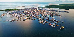 Core district of Sitangkai | |
 Flag | |
| Nicknames: Venice of the South Southernmost Settlement of the Philippines | |
 Map of Tawi-Tawi with Sitangkai highlighted | |
OpenStreetMap  | |
 Sitangkai Location within the Philippines | |
| Coordinates: 4°39′42″N119°23′31″E / 4.661528°N 119.391872°E | |
| Country | Philippines |
| Region | Bangsamoro Autonomous Region in Muslim Mindanao |
| Province | Tawi-Tawi |
| District | Lone district |
| Founded | August 26, 1959 |
| Barangays | 9 (see Barangays) |
| Government | |
| • Type | Sangguniang Bayan |
| • Mayor | Tiblan C. Ahaja |
| • Vice Mayor | Serbin C. Ahaja |
| • Representative | Dimszar M. Sali |
| • Municipal Council | Members |
| • Electorate | 27,418 voters (2025) |
| Area | |
• Total | 792.00 km2 (305.79 sq mi) |
| Elevation | 1.0 m (3.3 ft) |
| Highest elevation | 200 m (660 ft) |
| Lowest elevation | 0 m (0 ft) |
| Population (2024 census) [3] | |
• Total | 42,172 |
| • Density | 53.247/km2 (137.91/sq mi) |
| • Households | 6,842 |
| Economy | |
| • Income class | 1st municipal income class |
| • Poverty incidence | 57.62 |
| • Revenue | ₱ 352.8 million (2022) |
| • Assets | ₱ 267 million (2022) |
| • Expenditure | ₱ 347.5 million (2022) |
| • Liabilities | ₱ 22.94 million (2022) |
| Service provider | |
| • Electricity | Tawi Tawi Electric Cooperative (TAWELCO) |
| Time zone | UTC+8 (PST) |
| ZIP code | 7506 |
| PSGC | |
| IDD : area code | +63 (0)68 |
| Native languages | Sama Tagalog Sabah Malay |
| Website | www |
Sitangkai, officially the Municipality of Sitangkai (Tagalog : Bayan ng Sitangkai), is a municipality in the province of Tawi-Tawi, Philippines. According to the 2020 census, it has a population of 37,319 people. [5]
Contents
It is the southernmost place in the Philippines and is very close to Malaysia and Indonesia.
It is called the "Venice of the South" [6] due to the use of boats as primary transportation, although footbridges connect one house to another. The major sources of livelihood are fishing and farming, although there is very sparse agricultural land available.
This town is the southernmost town in the whole archipelago, and this town is the southernmost town in the province of Tawi-Tawi.
The Frances Reef located in the town of Sitangkai is geographically the southernmost point of the Philippines.

