Panglima Sugala فَڠْلِمَ سُݢَلَ Balimbing | |
|---|---|
| Municipality of Panglima Sugala | |
 Sunrise view of the sea at Panglima Sugala | |
 Flag | |
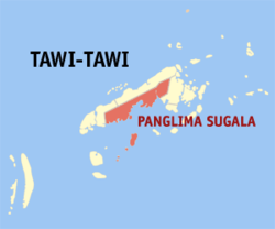 Map of Tawi-Tawi with Panglima Sugala highlighted | |
OpenStreetMap  | |
 Panglima Sugala Location within the Philippines | |
| Coordinates: 5°04′22″N119°53′05″E / 5.072786°N 119.884678°E | |
| Country | Philippines |
| Region | Bangsamoro Autonomous Region in Muslim Mindanao |
| Province | Tawi-Tawi |
| District | Lone district |
| Barangays | 17 (see Barangays) |
| Government | |
| • Type | Sangguniang Bayan |
| • Mayor | Nurbert Maquiso Sahali |
| • Vice Mayor | Dayang Iman M. Sahali |
| • Representative | Dimszar M. Sali |
| • Municipal Council | Members |
| • Electorate | 19,493 voters (2025) |
| Area | |
• Total | 416.66 km2 (160.87 sq mi) |
| Elevation | 5.0 m (16.4 ft) |
| Highest elevation | 539 m (1,768 ft) |
| Lowest elevation | 0 m (0 ft) |
| Population (2024 census) [3] | |
• Total | 52,657 |
| • Density | 130/km2 (330/sq mi) |
| • Households | 7,546 |
| Economy | |
| • Income class | 3rd municipal income class |
| • Poverty incidence | 41.91 |
| • Revenue | ₱ 267.8 million (2022) |
| • Assets | ₱ 582.3 million (2022) |
| • Expenditure | ₱ 212.6 million (2022) |
| • Liabilities | ₱ 115 million (2022) |
| Service provider | |
| • Electricity | Tawi Tawi Electric Cooperative (TAWELCO) |
| Time zone | UTC+8 (PST) |
| ZIP code | 7501 |
| PSGC | |
| IDD : area code | +63 (0)68 |
| Native languages | Sama Tagalog Sabah Malay |
| Website | www |
Panglima Sugala, officially the Municipality of Panglima Sugala (Filipino : Bayan ng Panglima Sugala), is a municipality in the province of Tawi-Tawi, Philippines. According to the 2020 census, it has a population of 48,055 people. [5] It was formerly known as Balimbing. [6]
Contents
The municipality's barangay Batu-batu was once the provincial capital of Tawi-Tawi until it was transferred in the municipality of Bongao in 1979.
The municipality was renamed from Balimbing to Panglima Sugala as per Muslim Mindanao Autonomy Act No. 7, enacted on July 4, 1991, and approved by the Regional Governor on September 9, 1991. [7]