
Los Santos is a province in Panama, reaching from the La Villa river in the North to the Pacific Ocean in the south and east. It is part of the Azuero Peninsula, bounded by the province of Herrera to the north and northeast, and by Mariato District of Veraguas Province to the West. The City of Las Tablas is the capital and most populous city. There are seven administrative districts under the jurisdiction of Los Santos Province. Los Santos's area is 3,809.4 km ², and its population is 98,466 inhabitants in 2023.
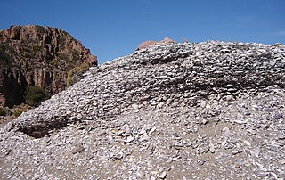
A midden is an old dump for domestic waste which may consist of animal bone, human excrement, botanical material, mollusc shells, potsherds, lithics, and other artifacts and ecofacts associated with past human occupation.

Watson Brake is an archaeological site in present-day Ouachita Parish, Louisiana, from the Archaic period. Dated to about 5400 years ago, Watson Brake is considered the oldest earthwork mound complex in North America. It is older than the Ancient Egyptian pyramids or Britain’s Stonehenge. Its discovery and dating in a paper published in 1997 changed the ideas of American archaeologists about ancient cultures in the Southeastern United States and their ability to manage large, complex projects over centuries. The archeologists revised their date of the oldest earthwork construction by nearly 2000 years, as well as having to recognize that it was developed over centuries by a hunter-gatherer society, rather than by what was known to be more common of other, later mound sites: a more sedentary society dependent on maize cultivation and with a hierarchical, centralized polity.
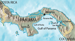
The Gulf of Panama is a gulf of the Pacific Ocean off the southern coast of Panama, where most of eastern Panama's southern shores adjoin it. The Gulf has a maximum width of 250 kilometres, a maximum depth of 220 metres (722 ft) and the size of 2,400 square kilometres (930 sq mi). The Panama Canal connects the Gulf of Panama with the Caribbean Sea, thus linking the Pacific and Atlantic oceans. The Panamanian capital Panama City is the main urban centre on the gulf shore.
The Caloosahatchee culture is an archaeological culture on the Gulf coast of Southwest Florida that lasted from about 500 to 1750 AD. Its territory consisted of the coast from Estero Bay to Charlotte Harbor and inland about halfway to Lake Okeechobee, approximately covering what are now Charlotte, Lee, and Collier counties. At the time of first European contact, the Caloosahatchee culture region formed the core of the Calusa domain.
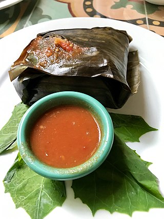
Ancient Maya cuisine was varied and extensive. Many different types of resources were consumed, including maritime, flora, and faunal material, and food was obtained or produced through strategies such as hunting, foraging, and large-scale agricultural production. Plant domestication concentrated upon several core foods, the most important of which was maize.

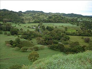
"Las Vegas culture" is the name given to many Archaic settlements which flourished between 8000 BCE and 4600 BCE near the coast of present-day Ecuador. The name comes from the location of the most prominent settlement, Site No. 80, near the Las Vegas River and now within the city of Santa Elena. The Las Vegas culture represents "an early, sedentary adjustment to an ecologically complex coastal environment."
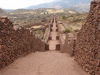
Pikillaqta is a large Wari culture archaeological site 20 kilometres (12 mi) east of Cusco in the Quispicanchi Province.
Guana Island is an island of the British Virgin Islands (BVI) in the Caribbean. One of the few remaining privately owned islands in its part of the world, Guana has seven white powder-sand beaches and 850 acres (3.4 km2) of tropical forest, mountains, hills, and valleys. The island is mostly natural preserve and has a small resort.

The archaeology of Iowa is the study of the buried remains of human culture within the U.S. state of Iowa from the earliest prehistoric through the late historic periods. When the American Indians first arrived in what is now Iowa more than 13,000 years ago, they were hunters and gatherers living in a Pleistocene glacial landscape. By the time European explorers visited Iowa, American Indians were largely settled farmers with complex economic, social, and political systems. This transformation happened gradually. During the Archaic period American Indians adapted to local environments and ecosystems, slowly becoming more sedentary as populations increased. More than 3,000 years ago, during the Late Archaic period, American Indians in Iowa began utilizing domesticated plants. The subsequent Woodland period saw an increase on the reliance on agriculture and social complexity, with increased use of mounds, ceramics, and specialized subsistence. During the Late Prehistoric period increased use of maize and social changes led to social flourishing and nucleated settlements. The arrival of European trade goods and diseases in the Protohistoric period led to dramatic population shifts and economic and social upheaval, with the arrival of new tribes and early European explorers and traders. During the Historical period European traders and American Indians in Iowa gave way to American settlers and Iowa was transformed into an agricultural state.

Gran Coclé is an archaeological culture area of the so-called Intermediate Area in pre-Columbian Central America. The area largely coincides with the modern-day Panamanian province of Coclé, and consisted of a number of identifiable native cultures. Archaeologists have loosely designated these cultures by pottery style. The poorly studied La Mula period ranged from 150 BC to AD 300. It was followed by the Tonosi period, from AD 300 to AD 550, and by the Cubita period, from AD 550 to AD 700. A unified Native American culture appears to have flourished in this area from approximately 1200 BC until the 16th century.
Barriles is one of the most famous archaeological sites in Panama. It is located in the highlands of the Chiriquí Province of Western Panama at 1200 meters above sea level. It is several kilometers west of the modern town of Volcán. This places the site in the Gran Chiriquí culture area. The site was originally named for several small stone barrels found in the area, although these have also been found elsewhere in the Río Chiriquí Viejo valley and in Costa Rica. This area has a cool, spring-like climate with a pronounced rainy season between May and November, and a dry but windy season the rest of the year. The region lies on the western flanks of Volcán Barú, a dormant volcano and the highest mountain in Panama.
Monagrillo is an archaeological site in south-central Panama with ceramics that have been shown by radiocarbon dating to have an occupation range of about 2500 BC—1200 BC. The site is important because it provides the earliest example of ceramics in Central America along with one of the earliest examples of maize agriculture in the region. The site lies along Panama's most fruitful seacoast. and reached a maximum living area of 1.4 ha

Sitio Conte is an archaeological site located in the Coclé province of Panama near Parita Bay. It can best be described as a necropolis and a "paradigmatic example of a ranked or chiefdom society". Based on dates from the goldwork and polychrome ceramics found at the site, its use is dated from approximately AD 450–900. While the site has remained untouched since the final excavations in 1940, its mortuary remains are considered to be a critical resource to archaeologists, as they aid in the interpretation of the social dynamics in the region between AD 500 and 1500.
Oña Canton is a canton of Ecuador, located in the Azuay Province. Its capital is the town of Oña, Ecuador. Its population at the 2001 census was 3,231.
Dolores Rita Piperno is an American archaeologist specializing in archaeobotany. She is a senior scientist emeritus of the Smithsonian Tropical Research Institute in Balboa, Panama and the Smithsonian National Museum of Natural History, Washington.
Fort Center is an archaeological site in Glades County, Florida, United States, a few miles northwest of Lake Okeechobee. It was occupied for more than 2,000 years, from 450 BCE until about 1700 CE. The inhabitants of Fort Center may have been cultivating maize centuries before it appeared anywhere else in Florida.

El Caño is one of Panama's most important archaeological sites, located in the area surrounding El Caño. Over the course of the 20th century archaeologists have been discovering several pre-Columbian burial sites at this location that are believed to date between 700 and 1000 AD. These burial sites have helped researchers gain a better understanding of the dynamic system of the hierarchical chiefdom-based societies created by the people who lived in this region of Central America before contact with Europeans.

The Gulf of Panama mangroves (NT1414) is an ecoregion along the Pacific coast of Panama and Colombia. The mangroves experience seasonal flooding with high levels of sediment, and occasional extreme storms or very low rainfall due to El Niño effects. They are important as a breeding or nursery area for marine species. Areas of the mangroves have been recognized as Important Bird Areas and Ramsar wetlands. The ecoregion has been severely degraded by clearance of mangroves for agriculture, pasturage and shrimp farming, by urban pressure around Panama City, and by pollution related to the Panama Canal.
Richard G. Cooke was an archaeologist who specialized in the archaeology of Panama and, more generally, the Isthmo-Colombian Area.