
Hampden County is a non-governmental county located in the Pioneer Valley of the U.S. state of Massachusetts, in the United States. As of the 2020 census, Hampden County's population was 465,825. Its traditional county seat is Springfield, the Connecticut River Valley's largest city, and economic and cultural capital; with an estimated population of 154,758, approximately one-third of Hampden County residents live in Springfield.

Springfield is the most populous city in and the seat of Hampden County, Massachusetts, United States. Springfield sits on the eastern bank of the Connecticut River near its confluence with three rivers: the western Westfield River, the eastern Chicopee River, and the eastern Mill River. At the 2020 census, the city's population was 155,929, making it the 3rd most populous city in the U.S. state of Massachusetts and the 4th most populous city in New England after Boston, Worcester, and Providence. Metropolitan Springfield, as one of two metropolitan areas in Massachusetts, had a population of 699,162 in 2020.

Agawam is a city in Hampden County, Massachusetts, United States. The population was 28,692 at the 2020 census. Agawam sits on the western side of the Connecticut River, directly across from Springfield. It is considered part of the Springfield Metropolitan Statistical Area, which is contiguous with the Knowledge Corridor area, the second-largest metropolitan area in New England. Agawam contains a subsection, Feeding Hills. The Six Flags New England amusement park is located in Agawam, on the banks of the Connecticut River.

Chicopee is a city located on the Connecticut River in Hampden County, Massachusetts, United States. At the 2020 census, the city had a population of 55,560, making it the second-largest city in western Massachusetts after Springfield. Chicopee is part of the Springfield, Massachusetts Metropolitan Statistical Area. The communities of Chicopee Center (Cabotville), Chicopee Falls, Willimansett, Fairview, Aldenville, Burnett Road, Smith Highlands and Westover are located within the city.

West Springfield is a city in Hampden County, Massachusetts, United States. It is part of the Springfield, Massachusetts Metropolitan Statistical Area. The population was 28,835 at the 2020 United States Census. The city is also known as "West Side", in reference to the fact that it is on the western side of the Connecticut River from Springfield, a fact which played a major part in the town's early history.

Forest Park in Springfield, Massachusetts, is one of the largest urban, municipal parks in the United States, covering 735 acres (297 ha) of land overlooking the Connecticut River. Forest Park features a zoo, aquatic gardens, and outdoor amphitheater, in addition to design elements like winding wooded trails, and surprising, expansive views. The site of America's first public, municipal swimming pool, currently, during the holiday months Forest Park hosts a popular high-tech lighting display, known as Bright Nights. Contrary to popular belief, the park was not designed by Frederick Law Olmsted, although it was designed by his firm.

The Big E, formally known as The Eastern States Exposition, is an annual fair in West Springfield, Massachusetts, which opens on the second Friday after Labor Day and runs for seventeen days.

Mattapan is a neighborhood in Boston, Massachusetts, United States. Historically and for legal processes a section of Dorchester, Mattapan became a part of Boston when Dorchester was annexed in 1870. Mattapan is the original Native American name for the Dorchester area, possibly meaning "a place to sit." At the 2010 census, it had a population of 36,480, with the majority of its population immigrants.

The MacDuffie School is a private, nonsectarian, coeducational college preparatory school for day and boarding students in grades 6–12. The school is located on over 250 acres in Granby, Massachusetts, United States, within close distance to the University of Massachusetts, and Amherst, Hampshire and Mount Holyoke colleges.

The Brooks Woodland Preserve is a 558-acre (226 ha) open space preserve located in Petersham, Massachusetts. The property, named after industrialist and diplomat James Wilson Brooks, is managed by the land conservation non-profit organization The Trustees of Reservations and offers 13 miles (21 km) of trails and primitive woods roads available for hiking, horseback riding, and cross country skiing. Second growth forest, overgrown farm fields, granite ledges, historic stone walls, creeks, and rolling hills characterize the preserve.
Vine Brook is a brook in Middlesex County, Massachusetts. According to the History of Bedford, Vine Brook is "an important tributary of Shawsheen River." The book also states it as an excellent source of water-power in the 17th to 19th Centuries.

East Forest Park is a neighborhood in the south central part of Springfield, Massachusetts. The neighborhood borders East Longmeadow, Forest Park, and the Sixteen Acres neighborhood. It is a primarily residential middle-class neighborhood.

Indian Orchard is a village in the City of Springfield, Massachusetts. Located in the northeast corner of Springfield, next to the Chicopee River, Indian Orchard is the city's fifth largest neighborhood.
The McKnight National Register Historic District is a neighborhood of Springfield, Massachusetts and was one of the first planned residential neighborhoods in the United States. It is one of the city's smallest neighborhoods, at 306.5 acres.
The Bay neighborhood is located in Springfield, Massachusetts. It covers 556.5 acres of land, making it one of the city's smallest neighborhoods.

The City of Springfield, Massachusetts, has 19 distinct neighborhoods. Many feature subdivisions known by other names, such as The X, Hungry Hill, and Mason Square. Springfield's neighborhoods fan out north, south, and east, from its original, colonial settlement in what is now Metro Center.
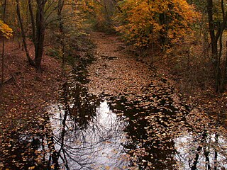
The Mill River is a 1.25-mile-long (2.01 km) tributary of the Connecticut River in Springfield, Massachusetts. It flows from Watershops Pond to its confluence with the Connecticut River. It is referred to as "The Miracle Mile" in a 2009 master's thesis that outlines possibilities for reclaiming the river's mouth as a recreational area. As of 2011, the final 350 feet (110 m) of the river, including its mouth, is confined in a pipe underneath Interstate 91, railroad tracks and a car dealership. Many Springfield residents have bemoaned the loss of the Mill River as a recreational area, and hope to gain greater access to both it and the Connecticut River in upcoming years. As it has for over a century, today the Mill River serves as a barrier between Springfield neighborhoods. Surrounding it are some of the most densely urbanized locations in Springfield.

C3 policing, also known as the Avghani model, is a crime prevention strategy for civilian law enforcement, loosely developed from military counterinsurgency strategies and currently used in the cities of Springfield and Chicopee in Hampden County, Massachusetts, United States.

The history of Springfield, Massachusetts dates back to the colonial period, when it was founded in 1636 as Agawam Plantation, named after a nearby village of Algonkian-speaking Native Americans. It was the northernmost settlement of the Connecticut Colony. The settlement defected from Connecticut after four years, however, later joining forces with the coastal Massachusetts Bay Colony. The town changed its name to Springfield, and changed the political boundaries among what later became the states of New England. The decision to establish a settlement sprang in large part from its favorable geography, situated on a steep bluff overlooking the Connecticut River's confluence with three tributaries. It was a Native American crossroad for two major trade routes: Boston-to-Albany and New York City-to-Montreal. Springfield also sits on some of the northeastern United States' most fertile soil.

Stone Dog II is a granite statue of a golden retriever posed standing guard in front of the Zoo at Forest Park in Springfield, Massachusetts. This 2013 statue, crafted by Getty Granite in Connecticut, replaced the original Stone Dog which went missing from the park in 1987, and continues a tradition with roots in the late 19th century. The present statue is almost identical to the original, measuring about 2.5 feet tall, 4 feet long, and 2 feet wide, and weighing approximately 1,000 pounds.

