
East Forest Park is a neighborhood in the south central part of Springfield, Massachusetts. The neighborhood borders East Longmeadow, Forest Park, and the Sixteen Acres neighborhood. It is a primarily residential middle-class neighborhood.
East Forest Park is a neighborhood in the south central part of Springfield, Massachusetts. The neighborhood borders East Longmeadow, Forest Park, and the Sixteen Acres neighborhood. It is a primarily residential middle-class neighborhood.
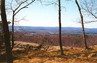
East Forest Park contains a wide variety of pre and post-World War II homes on the hillside of Watershops Pond, Springfield's largest body of water (other than the Connecticut River) and custom-built colonials and Tudors as well as capes and ranches. [1]
Several small commercial areas are located on Island Pond Road and Sumner Avenue. The neighborhood was home to Cathedral High School, formerly the city's only Catholic secondary school. It merged with a Catholic school from Holyoke, becoming Pope Francis Preparatory School. In late 2019 the new home of the East Forest Park branch of the Springfield City Library was opened. [2]
A section of the Highland Division Railroad, which ran from Enfield, Connecticut, to Springfield, ran through the neighborhood until it was decommissioned in 1993. [3] In the years since, multiple proposals have been made to replace the abandoned sections of track with walking or biking trails, although none have come to fruition as of 2023. [3] [4]
The neighborhood was hit hard by the June 1, 2011 New England tornado outbreak. [5] [6]

Hampden County is a non-governmental county located in the Pioneer Valley of the state of Massachusetts, in the United States. As of the 2020 census, Hampden County's population was 465,825. Its traditional county seat is Springfield, the Connecticut River Valley's largest city, and economic and cultural capital; with an estimated population of 154,758, approximately 1 in 3 residents of Hampden County live in Springfield.

Springfield is the most populous city in and the seat of Hampden County, Massachusetts, United States. Springfield sits on the eastern bank of the Connecticut River near its confluence with three rivers: the western Westfield River, the eastern Chicopee River, and the eastern Mill River. At the 2020 census, the city's population was 155,929, making it the 3rd most populous city in the U.S. state of Massachusetts and the 4th most populous city in New England after Boston, Worcester, and Providence. Metropolitan Springfield, as one of two metropolitan areas in Massachusetts, had a population of 699,162 in 2020.

Chicopee is a city located on the Connecticut River in Hampden County, Massachusetts, United States. At the 2020 census, the city had a population of 55,560, making it the second-largest city in western Massachusetts after Springfield. Chicopee is part of the Springfield, Massachusetts Metropolitan Statistical Area. The communities of Chicopee Center (Cabotville), Chicopee Falls, Willimansett, Fairview, Aldenville, Burnett Road, Smith Highlands and Westover are located within the city.

East Longmeadow is a city in Hampden County, Massachusetts, United States situated in the Pioneer Valley region of Western Massachusetts. It had a population of 16,430 at the 2020 census. East Longmeadow is 5 mi (8.0 km) southeast of downtown Springfield, part of the Springfield Metropolitan Statistical Area. Additionally, the town is 25 mi (40 km) north of Hartford, 88 mi (142 km) southwest of Boston, and 142 mi (229 km) northeast of New York City.

Westfield is a city in Hampden County, in the Pioneer Valley of western Massachusetts, United States. Westfield was first settled by Europeans in 1660. It is part of the Springfield, Massachusetts Metropolitan Statistical Area. The population was 40,834 at the 2020 census.

The city of Northampton is the county seat of Hampshire County, Massachusetts, United States. As of the 2020 census, the population of Northampton was 29,571.

West Springfield is a city in Hampden County, Massachusetts, United States. It is part of the Springfield, Massachusetts Metropolitan Statistical Area. The population was 28,835 at the 2020 United States Census. The city is also known as "West Side", in reference to the fact that it is on the western side of the Connecticut River from Springfield, a fact which played a major part in the town's early history.

Forest Park in Springfield, Massachusetts, is one of the largest urban, municipal parks in the United States, covering 735 acres (297 ha) of land overlooking the Connecticut River. Forest Park features a zoo, aquatic gardens, and outdoor amphitheater, in addition to design elements like winding wooded trails, and surprising, expansive views. The site of America's first public, municipal swimming pool, currently, during the holiday months Forest Park hosts a popular high-tech lighting display, known as Bright Nights. Contrary to popular belief, the park was not designed by Frederick Law Olmsted, although it was designed by his firm.
Provin Mountain is a very narrow traprock mountain ridge located in the Connecticut River Valley of Massachusetts. It is part of the Metacomet Ridge which extends from Long Island Sound near New Haven, Connecticut, north through the Connecticut River Valley of Massachusetts to the Vermont border. Provin Mountain is known for its scenic cliffs, unique microclimate ecosystems, and rare plant communities. It is traversed by the 114 mile (183 km) Metacomet-Monadnock Trail.


Forest Park is a Victorian garden district located in Springfield, Massachusetts, developed between 1880 and 1920. It is the city's most populous neighborhood, and surrounds the 735-acre Forest Park, for which the neighborhood is named. The Forest Park neighborhood has nature and recreation within walking distance. To the west, I-91 separates Forest Park from the Connecticut River. A 195-acre section of the neighborhood was listed on the National Register of Historic Places in 1982 as the Forest Park Heights Historic District.
Boston Road is Springfield, Massachusetts's principal commercial and retail corridor, located on the eastern edge of the city. The Boston Road neighborhood, historically known as Springfield Plain, is named for being a major waypoint on the Boston Post Road system.

Sixteen Acres is a neighborhood in Springfield, Massachusetts. Much of the neighborhood was constructed after World War II and is suburban in character. Unlike what its name might suggest, the neighborhood covers 4,506 acres.

On June 1, 2011, a total of six tornadoes touched down in both western Massachusetts and western Maine. The strongest was a long-track, high-end EF3 tornado that caused significant damage to the city of Springfield, Massachusetts as well as several adjacent cities and towns. By the end of the day, three people had been killed, at least 200 were injured, and over 500 families were left homeless.

The City of Springfield, Massachusetts, has 19 distinct neighborhoods. Many feature subdivisions known by other names, such as The X, Hungry Hill, and Mason Square. Springfield's neighborhoods fan out north, south, and east, from its original, colonial settlement in what is now Metro Center.
The Mill River is a 1.25-mile-long (2.01 km) tributary of the Connecticut River in Springfield, Massachusetts. It flows from Watershops Pond to its confluence with the Connecticut River. It is referred to as "The Miracle Mile" in a 2009 master's thesis that outlines possibilities for reclaiming the river's mouth as a recreational area. As of 2011, the final 350 feet (110 m) of the river, including its mouth, is confined in a pipe underneath Interstate 91, railroad tracks and a car dealership. Many Springfield residents have bemoaned the loss of the Mill River as a recreational area, and hope to gain greater access to both it and the Connecticut River in upcoming years. As it has for over a century, today the Mill River serves as a barrier between Springfield neighborhoods. Surrounding it are some of the most densely urbanized locations in Springfield.

The history of Springfield, Massachusetts dates back to the colonial period, when it was founded in 1636 as Agawam Plantation, named after a nearby village of Algonkian-speaking Native Americans. It was the northernmost settlement of the Connecticut Colony. The settlement defected from Connecticut after four years, however, later joining forces with the coastal Massachusetts Bay Colony. The town changed its name to Springfield, and changed the political boundaries among what later became the states of New England. The decision to establish a settlement sprang in large part from its favorable geography, situated on a steep bluff overlooking the Connecticut River's confluence with three tributaries. It was a Native American crossroad for two major trade routes: Boston-to-Albany and New York City-to-Montreal. Springfield also sits on some of the northeastern United States' most fertile soil.
The Zoo In Forest Park and Education Center, also known as the Forest Park Zoo, is a nonprofit zoo situated in Forest Park, Springfield, Massachusetts. It spans an area of four acres and is home to a variety of exotic, native, and endangered species.
Bright Nights is an annual holiday lights display held in Forest Park in Springfield, Massachusetts. The event is run collaboratively between Springfield's Department of Parks, Buildings & Recreation Management and local nonprofit Spirit of Springfield. The event usually runs from Thanksgiving week until January 1 or 2.

Dwight is a village in North Belchertown, Massachusetts, United States. It was a railroad destination and farming community in the 19th century with lumber mills, two schools, a chapel, cemeteries, two railways, aquatic gardens, restaurants, ballrooms, an inn, a silk mill, a cider mill, a carriage-maker, wheelwright, gunsmith and blacksmith, a general store and post office. Today the area is known for its natural beauty, scenic waterfalls, wildlife, forests, ponds, brooks, springs, hiking trails and bike paths.
| Topics |  | |
|---|---|---|
| Attractions | ||
| Government | ||
| Neighborhoods | ||
| Sports | ||
| Transportation | ||