Troms (pronounced [trʊms] or Romsa or Tromssa is a county in northern Norway. It borders Finnmark county to the northeast and Nordland county in the southwest. Norrbotten Län in Sweden is located to the south and further southeast is a shorter border with Lapland Province in Finland. To the west is the Norwegian Sea.

Sunndal (help·info) is a municipality in the Nordmøre region located in the northeast part of Møre og Romsdal county, Norway. The administrative center of the municipality is the village of Sunndalsøra. Other villages include Gjøra, Grøa, Hoelsand, Jordalsgrenda, Romfo, Ålvund, Ålvundeidet, and Øksendalsøra. With an area of 1,712 square kilometres (661 sq mi), it is the largest municipality in Møre og Romsdal county. The important occupations in Sunndal include industry, public services, retail, and farming.
Ørsta (help·info) is a municipality in Møre og Romsdal county, Norway. It is part of the Sunnmøre region of Western Norway. The administrative centre of the municipality is the village of Ørsta. Other villages in the municipality include Hovdebygda, Flåskjer, Leira, Liadal, Urke, Bjørke, Barstadvik, Åmdalen, Follestaddalen, Nordre Vartdal, Vartdal, Sæbø, Sætre, Store-Standal, and Ytre Standal.

Lysefjord or Lysefjorden is a fjord located in the Ryfylke area in southwestern Norway. The 42-kilometre (26 mi) long fjord lies in Forsand municipality in Rogaland county, about 25 kilometres (16 mi) east of the city of Stavanger. The name means light fjord, and is said to be derived from the lightly coloured granite rocks along its sides. It is particularly well known by the huge Preikestolen cliff overlooking the fjord, which is a major tourist destination for the region. The fairly isolated village of Lysebotn lies at the eastern end of the fjord and the villages of Forsand and Oanes both lie at the western end of the fjord near the Lysefjord Bridge, the only crossing of the fjord.

Magerøya is a large island in Finnmark county, in the extreme northern part of Norway. The island lies along the Barents Sea in Nordkapp Municipality, just north of the Porsanger Peninsula. The mouth of Porsangerfjorden lies off the east coast of the island.

Femunden is Norway's third largest lake and the second largest natural lake in Norway. It is located in Hedmark and Trøndelag counties in Norway, just 13 kilometres (8.1 mi) west of the border with Sweden. The lake lies primarily in the municipality of Engerdal and also smaller parts are located in the municipalities of Os (Hedmark) and Røros (Trøndelag). Femundsmarka National Park borders the northeastern part of the lake.

The Sognefjord or Sognefjorden, nicknamed the King of the Fjords, is the largest and deepest fjord in Norway. Located in Sogn og Fjordane county in Western Norway, it stretches 205 kilometres (127 mi) inland from the ocean to the small village of Skjolden in the municipality of Luster. The fjord takes its name from the traditional district of Sogn, which covers the southern part of the county.

European highway E 134 is a European highway that crosses Norway starting near the city of Haugesund on the west coast, heading over Haukeli, passing the city of Drammen, and ending in the municipality of Frogn near the national capital of Oslo.
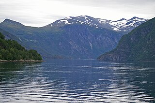
Tafjord is a village in Norddal Municipality in Møre og Romsdal county, Norway. The village is in a valley located at the end of the Tafjorden, about 12 kilometres (7.5 mi) southeast of the municipal centre of Sylte, and just west of the borders of Reinheimen National Park. In the park, the mountains Tordsnose, Karitinden, and Puttegga all lie about 15 kilometres (9.3 mi) to the southeast of Tafjord in the Tafjordfjella mountain range.

Skyvatn is a lake in the northern part of the municipality of Bykle in Aust-Agder county, Norway. The lake is located south of the lake Holmavatnet and northwest of the lake Hartevatnet. The village of Hovden in Bykle is the nearest village, located about 9 kilometres (5.6 mi) southeast of the lake.

Trolla is a village in the municipality of Trondheim in Trøndelag county, Norway. It is located in the Midtbyen borough, along the Trondheimsfjord on the north coast of the Bymarka area. It is about 10 kilometres (6.2 mi) northeast of the village of Langørjan and about 4 kilometres (2.5 mi) northwest of the Ila neighborhood in the city of Trondheim. The 0.24-square-kilometre (59-acre) village has a population (2017) of 511 which gives the village a population density of 2,129 inhabitants per square kilometre (5,510/sq mi).

Trollheimen is a mountain range in Møre og Romsdal and Trøndelag counties in central Norway. The mountain range is part of the Scandinavian Mountains.

Havvannet (Norwegian) or Vuolit Áhpelanjávri is a lake in Måsøy Municipality in Finnmark county, Norway. The 3.69 square kilometres (1.42 sq mi) lake lies isolated in the mountains on the Porsanger Peninsula about 9 kilometres (5.6 mi) northeast of the village of Kokelv in Kvalsund Municipality. The lake sits at an elevation of 293-metre (961 ft) above sea level. The village of Slåtten lies about 14 kilometres (8.7 mi) northwest of the lake.

Innfjorden is a village in Rauma Municipality in Møre og Romsdal county, Norway. It is situated about 10 kilometres (6.2 mi) southwest of the town of Åndalsnes and 9 kilometres (5.6 mi) southeast of the village of Måndalen along the European Route E136 highway. The road from Åndalsnes to Innfjorden goes through the 6,594-metre (21,634 ft) long Innfjord Tunnel, which opened in 1991 after a series of deaths caused by avalanches on the former road along the shore of Romsdal Fjord.

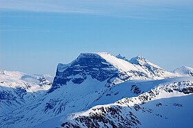
Trolla is a mountain in the Trollheimen mountain range in Sunndal Municipality in Møre og Romsdal county, Norway. It is located about 10 kilometres (6.2 mi) east of the village of Sunndalsøra and about 3.5 kilometres (2.2 mi) north of the village of Grøa. The mountain is made up of several peaks along the ridge of the mountain:

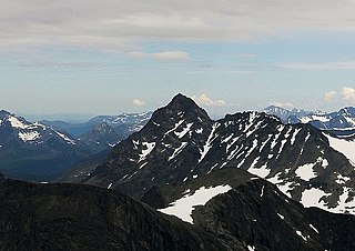
Såtbakkollen is a 1,632-metre (5,354 ft) tall mountain in Sunndal Municipality in Møre og Romsdal county, Norway. It is located in the Trollheimen mountain range, just north of the Sunndalen valley. It forms the southern end of the "Tårn massif", which also includes Tåga, Tårnfjellet, and the quite famous Innerdalstårnet. Other mountains nearby include Navardalsnebba, Trolla, and Skarfjellet.
Romsdalsalpane is mountain range surrounding the Romsdalen valley in Møre og Romsdal county, Norway. They are primarily located in Rauma Municipality, Nesset Municipality, and Norddal Municipality. The southern part of the mountain range is also located within Reinheimen National Park. The famous Trollstigen road is runs over a pass in this mountain range.

Aurlandsfjord is a fjord in Sogn og Fjordane county, Norway. The fjord flows through the municipalities of Aurland, Vik, and Lærdal. The 29-kilometre (18 mi) long fjord is a branch off of the main Sognefjorden, Norway's longest fjord. The fjord is deep and narrow, reaching a depth of about 962 metres (3,156 ft) below sea level, and its width is generally less than 2 kilometres (1.2 mi) wide. About 11 kilometers (6.8 mi) south of the mouth of the fjord, the Nærøyfjord branches off from it to the west. The village of Flåm sits at the innermost part of the Aurlandsfjord; other villages along the fjord are Aurlandsvangen and Undredal. Most of the fjord is surrounded by up to 1,800-metre (5,900 ft) tall, steep mountains with little habitation along the fjord except for in a few small valleys.