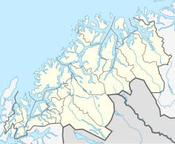
Troms is a county in northern Norway. It borders Finnmark county to the northeast and Nordland county in the southwest. Norrbotten Län in Sweden is located to the south and further southeast is a shorter border with Lapland Province in Finland. To the west is the Norwegian Sea. The county had a population of 169,610 in 2024.

Finnmark is a county in the northern part of Norway.

Porsanger is a municipality in Finnmark county, Norway. The administrative centre of the municipality is the village of Lakselv. Other villages in the municipality include Børselv, Brenna, Indre Billefjord, Kistrand, Olderfjord, and Skoganvarre.
Balsfjord is a municipality in Troms county, Norway. The administrative centre of the municipality is the village of Storsteinnes. Other notable villages include Mestervik, Mortenhals, and Nordkjosbotn.

Lyngen is a municipality in Troms county, Norway. The administrative centre of the municipality is the village of Lyngseidet. Other notable villages include Furuflaten, Lattervika, Nord-Lenangen, and Svensby.

Storfjord (Norwegian), Omasvuotna, or Omasvuono (Kven) is a municipality in Troms county, Norway. The administrative centre of the municipality is the village of Hatteng. Other villages in Storfjord include Elvevoll, Oteren, and Skibotn.

Kåfjord (Norwegian), Gáivuotna[ˈkaːjːvuo̯tna] (Northern Sami), or Kaivuono (Kven) is a municipality in Troms county, Norway. The administrative centre of the municipality is the village of Olderdalen. Other notable villages include Løkvollen, Manndalen, Birtavarre, Trollvik, Samuelsberg, Nordmannvik, and Djupvik.

Skjervøy Municipality is a municipality in Troms county, Norway. The administrative centre of the municipality is the town of Skjervøy on the island of Skjervøya, where most of the inhabitants live. The main industries are fishing and shipbuilding. Other villages in the municipality include Akkarvik and Arnøyhamn.

Nordreisa (Norwegian), Ráisa, or Raisi (Kven) is a municipality in Troms county, Norway. The administrative centre of the municipality is the village of Storslett. Other villages include Oksfjordhamn, Sørkjosen, and Rotsund.

Kvænangen is a municipality in Troms county, Norway. The administrative centre of the municipality is the village of Burfjord. Other notable villages in the municipality include Alteidet, Badderen, Kjækan, and Sekkemo. The European route E6 highway goes through the municipality and over the Sørstraumen Bridge, and many people stop at the Kvænangsfjellet pass to view the scenery of the Kvænangen fjord.
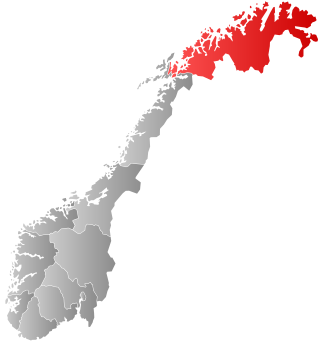
Northern Norway is a geographical region of Norway, consisting of the three northernmost counties Nordland, Troms and Finnmark, in total about 35% of the Norwegian mainland. Some of the largest towns in Northern Norway are Mo i Rana, Bodø, Narvik, Harstad, Tromsø and Alta. Northern Norway is often described as the land of the midnight sun and the land of the northern lights. Farther north, halfway to the North Pole, is the Arctic archipelago of Svalbard, traditionally not regarded as part of Northern Norway.

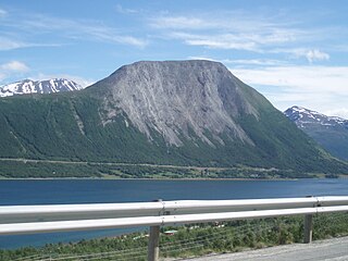
The Lyngen Alps (Norwegian: Lyngsalpan or Lyngsfjellan, Northern Sami: Ittuvárit, or Kven: Yykeänvaarat are a mountain range in northeastern Troms county in Norway, east of the city of Tromsø. The mountain range is located on the Lyngen Peninsula and it runs through Lyngen Municipality, Balsfjord Municipality, Storfjord Municipality, and Tromsø Municipality. The mountains follow the western shore of the Lyngen fjord in a north-south direction. The length of the range is at least 90 kilometres and the width is 15–20 kilometres. The mountains dominate the Lyngen Peninsula, which is bordered by the Lyngen fjord to the east, and the Ullsfjorden to the west.

Furuflaten (Norwegian), Vuošvággi (Northern Sami), or Vuosvankka (Kven) is a village in Lyngen Municipality in Troms county, Norway. The village is located along the Lyngen fjord. Furuflaten is located at the mouth of the Lyngsdalselva river, about 15 kilometres (9.3 mi) south of the village of Lyngseidet and about 54 kilometres (34 mi) straight southeast of the city of Tromsø.
Olderdalen (Norwegian), Dálusvággi or Dálvvesvággi (Northern Sami), or Talosvankka (Kven) is the administrative centre of the municipality of Kåfjord Municipality in Troms county, Norway. Olderdalen is located in the Olderdalen valley along the Kåfjorden with a view of the Lyngen Alps. The village has a ferry connection to Lyngseidet, the administrative centre of Lyngen Municipality, across the fjord. The European route E6 highway passes through this village also.
Sørkjosen (Norwegian), Reaššegeahči (Northern Sami), or Rässikäinen (Kven) is a village in Nordreisa Municipality in Troms county, Norway. The village is located along the shores of the Reisafjorden about 5 kilometres (3.1 mi) northwest of the municipal center of Storslett. Sørkjosen has many industries including fishing, dairy production, and a sawmill.

Malangen (Norwegian) or Málatvuotna (Northern Sami) is a fjord in Troms county, Norway. The 60-kilometre (37 mi) long fjord runs through the municipalities of Balsfjord, Målselv, Senja, and Tromsø. The fjord runs southeast between the islands of Senja and Kvaløya and further into the mainland along the border between Balsfjord and Senja municipalities.

Ullsfjorden (Norwegian) or Olggosvuotna (Northern Sami) is a fjord in Troms county, Norway. The fjord runs through the municipalities of Tromsø, Karlsøy, and Lyngen. The 75-kilometre (47 mi) fjord flows from the village of Sjøvassbotn northwards along the west side of the Lyngen Peninsula. The Kjosen fjord branches off to the east side and the Grøtsundet strait branches off to the west. The islands of Reinøya and Karlsøya lie along the western side of the fjord. The southern part of the Ullsfjorden is also known as Sørfjorden. The area surrounding the Ullsfjorden was part of Ullsfjord Municipality for about 60 years during the 20th century.

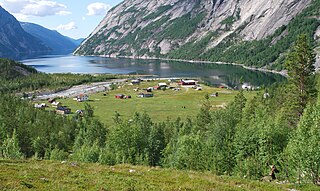
Lyngen (Norwegian), Ivguvuotna (Northern Sami), or Yykeänvuono (Kven) is a fjord in Troms county, Norway. The 82-kilometre (51 mi) long fjord is the longest fjord in Troms county and it is often used as the dividing line between "northern Troms" and "southern Troms". The fjord is located within the municipalities of Skjervøy, Nordreisa, Lyngen, Gáivuotna–Kåfjord, and Storfjord. It stretches from the village of Hatteng in Storfjord Municipality in the south all the way north to the islands of Skjervøy Municipality. The Lyngen Alps lie on the Lyngen Peninsula along the western shore of the fjord. The European route E06 highway runs along the eastern shore of the fjord. The Kåfjorden branches off of the main fjord on the east side, and the southernmost part of the fjord is also known as the Storfjorden.
Kjækan (Norwegian), Kätkänen (Kven), or Geahkkán (Northern Sami) is a village in Kvænangen Municipality in Troms county, Norway.
Troms og Finnmark was a county in northern Norway that existed from 2020 to 2023. The county was established on 1 January 2020 as the result of a regional reform. It was the largest county by area in Norway, encompassing about 75,000 square kilometres (29,000 sq mi), and was formed by the merger of the former Finnmark and Troms counties in addition to Tjeldsund Municipality from Nordland county.