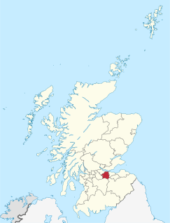
West Lothian is one of the 32 council areas of Scotland, and was one of its historic counties. The county, which was known as Linlithgowshire, was bounded geographically by the Avon to the west and the Almond to the east. The modern council area occupies a larger area than the historic county. It was reshaped following local government reforms in the late 20th century: some areas in the west were transferred to Falkirk; some areas in the east were transferred to Edinburgh; and some areas that had formerly been part of in Midlothian were added.
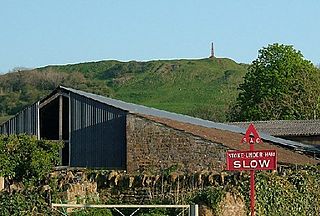
Ham Hill is a geological Site of Special Scientific Interest (SSSI), Scheduled Ancient Monument, Iron Age hill fort, Roman site, Local Nature Reserve and country park, to the west of Yeovil in Somerset, England.
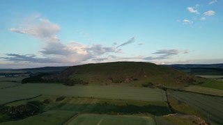
Traprain Law is a hill 6 km (4 mi) east of Haddington, East Lothian, Scotland, It is the site of a hill fort or possibly oppidum, which covered at its maximum extent about 16 ha. It is the site of the Traprain Law Treasure, the largest Roman silver hoard from anywhere outside the Roman Empire which included exquisite silver artefacts.

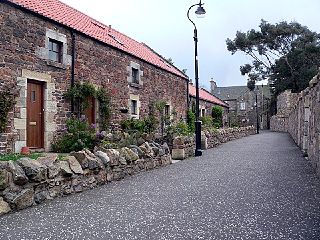
Cramond Village is a village and suburb in the north-west of Edinburgh, Scotland, at the mouth of the River Almond where it enters the Firth of Forth.

The Scott Monument is a Victorian Gothic monument to Scottish author Sir Walter Scott. It is the second largest monument to a writer in the world after the José Martí monument in Havana. It stands in Princes Street Gardens in Edinburgh, opposite the Jenners department store on Princes Street and near to Edinburgh Waverley Railway Station, which is named after Scott's Waverley novels.
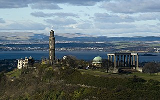
Calton Hill is a hill in central Edinburgh, Scotland, situated beyond the east end of Princes Street and included in the city's UNESCO World Heritage Site. Views of, and from, the hill are often used in photographs and paintings of the city.

Titterstone Clee Hill, sometimes referred to as Titterstone Clee or Clee Hill, is a prominent hill in the rural English county of Shropshire, rising at the summit to 533 metres (1,749 ft) above sea level.

Binsey is a hill on the northern edge of the Lake District in Cumbria, England. It is detached from the rest of the Lakeland hills, and thus provides a good spot to look out at the Northern and North Western Fells of the Lake District, as well as the coastal plain and, across the Solway Firth, Scotland. Snaefell on the Isle of Man is also visible on a clear day. It is the northernmost of the Wainwrights.
Drem is a small village in East Lothian, Scotland.

The Hopetoun Monument is a monument in the Garleton Hills, near Camptoun, East Lothian, Scotland. It is 95 feet (29 m) tall and is situated on Byres Hill near Haddington.
Torphin is a small area in the south-west of Edinburgh, Scotland, with its name deriving from the nearby Torphin Hill. It lies just south of Juniper Green, on the opposite side of the Water of Leith, and sits both east and west of the Edinburgh City Bypass: the east side mostly comprises new-build houses; the west side is largely rural, sporting a small number of mid-20th Century bungalows and one of the city's many golf courses, Torphin Hill Golf Club.

Torphichen is a historic small village located north of Bathgate in West Lothian, Scotland. The village is approximately 18 miles west of Edinburgh, 7 miles south-east of Falkirk and 4 miles south-west of Linlithgow. The village had a population of 570 in the and a population of 710 in 2016. Torphichen's placename may be Gaelic in origin, e.g., "Tóir Féichín", Tor Fithichean, or Brythonic "tref fechan".

Barnes Castle is an unfinished castle, with a number of defensive banks, located 5 kilometres (3.1 mi) north-east of Haddington in East Lothian, Scotland. It is close to Athelstaneford on the slopes of the Garleton Hills. The remains, also known as Barney Vaults or The Vaults, are protected as a scheduled monument.

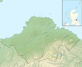
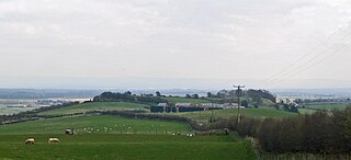
The Garleton Hills, in East Lothian, Scotland, are a range of igneous hills, to the north of Haddington.
Eddisbury hill fort, also known as Castle Ditch, is an Iron Age hill fort near Delamere, Cheshire, in northern England. Hill forts are fortified hill-top settlements constructed across Britain during the Iron Age. Eddisbury is the largest and most complex of the seven hill forts in the county of Cheshire. It was constructed before 200–100 BC and expanded in 1–50 AD. In the 1st century AD, the Romans slighted the site. It was reoccupied in the 6th–8th centuries AD, and an Anglo-Saxon burh was probably established at Eddisbury in 914. In the medieval and post-medieval periods quarrying and farming have damaged the site. Ownership is currently split between the Forestry Commission and a local farm. Eddisbury is protected as a Scheduled Ancient Monument.

Rubers Law is a prominent, conical hill in the Scottish Borders area of south-east Scotland. It stands on the south bank of the River Teviot, between the towns of Hawick and Jedburgh, and south of the village of Denholm. The hill is on the border between the historic parishes of Cavers and Hobkirk, and until 1975 it stood within the historic county of Roxburghshire.

Trencrom Hill is a prominent hill fort, owned by the National Trust, near Lelant, Cornwall. It is crowned by an univallate Neolithic tor enclosure and was re-used as a hillfort in the Iron Age. Cairns or hut circles can be seen in the level area enclosed by the stone and earth banks. The hill overlooks the Hayle Estuary and river, and Mount's Bay and St Michael's Mount can be seen to the south. The hill was recorded as Torcrobm in 1758 which is derived from Cornish "torr crobm", i.e. 'hunched bulge'.
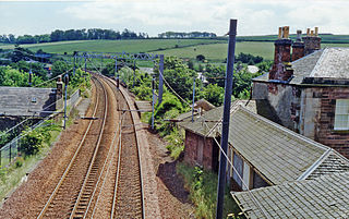
East Linton railway station served the village of East Linton in Scotland between 1846 and 1964. It was on the main line of the North British Railway.
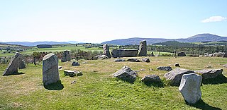
Tomnaverie stone circle is a recumbent stone circle set on the top of a small hill in lowland northeast Scotland. Construction started from about 2500 BC, in the Bronze Age, to produce a monument of thirteen granite stones including a massive 6.5-ton recumbent stone lying on its side along the southwest of the circle's perimeter. Within the 17-metre (56 ft) circle are kerb stones encircling a low 15-metre (49 ft) ring cairn but the cairn itself no longer exists.