Bardu is a municipality in Troms county, Norway. The administrative centre of the municipality is the village of Setermoen, the largest urban area in the municipality.

Målselv is a municipality in Troms county, Norway. The administrative centre of the municipality is the village of Moen. The main commercial centre of the municipality is the Bardufoss area. Other villages in the municipality include Alappmoen, Fossmoen, Holmen, and Skjold. Besides bordering Sweden to the east and the ocean to the northwest, it borders the municipalities of Balsfjord, Storfjord, Bardu, Sørreisa, and Lenvik.

Sørreisa is a municipality in Troms county, Norway. The administrative centre of the municipality is the village of Sørreisa. Other villages include Grunnreisa, Skøelva, and Smørsgård.

Lenvik is a former municipality that was located in the old Troms county, Norway. The municipality existed from 1838 until its dissolution in 2020. The municipality was partly situated on the mainland and partly on the island of Senja in what is now Senja Municipality. The administrative centre was the town of Finnsnes, where the Gisund Bridge connects Senja to the mainland on Norwegian County Road 86. Other villages in the municipality included Aglapsvik, Gibostad, Botnhamn, Fjordgård, Finnfjordbotn, Husøy, Langnes, Laukhella, Silsand, and Rossfjordstraumen. The lake Lysvatnet was located in the municipality on Senja island, west of Gibostad.
Balsfjord is a municipality in Troms county, Norway. The administrative centre of the municipality is the village of Storsteinnes. Other villages include Mestervik, Mortenhals, and Nordkjosbotn.

Bardufoss is a town and commercial centre in Målselv Municipality in Troms county, Norway. The three villages of Andselv, Andslimoen, and Heggelia together form the Bardufoss area. Bardufoss is located in the Målselvdalen valley near the confluence of the Barduelva and Målselva rivers. It is located about 82 kilometres (51 mi) north of the town of Narvik and about 70 kilometres (43 mi) south of the city of Tromsø. Bardufoss Airport is located here. The 2.96-square-kilometre (730-acre) urban area has a population (2017) of 2,545 which gives it a population density of 860 inhabitants per square kilometre (2,200/sq mi).

Malangen is a former municipality in Troms county in Norway. The 372-square-kilometre (144 sq mi) municipality existed from 1871 until its dissolution in 1964. The old municipality surrounded the Malangen fjord and today that area is divided between the municipalities of Balsfjord, Lenvik, Tromsø, and Målselv. The administrative centre was the village of Mortenhals where the main church for the municipality, Malangen Church, is located.
Skjold is an army camp in the small village Øverbygd in the municipality of Målselv in Troms county, Norway. This camp is part of the Northern Brigade of the Norwegian Army and is where the 2nd Battalion Mechanized Infantry and Combat and Construction Engineers are based.
Moen is the administrative centre of Målselv Municipality in Troms county, Norway. The village of Moen is located in the Målselvdalen valley about 10 km (6.2 mi) north of the village of Andselv and Bardufoss Airport. The 0.89-square-kilometre (220-acre) village has a population (2017) of 847 which gives the village a population density of 952 inhabitants per square kilometre (2,470/sq mi).

Setermoen is the administrative centre of Bardu Municipality in Troms county, Norway. The village is located along the Barduelva river, about 25 kilometres (16 mi) east of the village of Sjøvegan and about 25 kilometres (16 mi) south of Bardufoss.
Andselv is a village in Målselv Municipality in Troms county, Norway. The village lies along the Andselva river in the urban area called Bardufoss. Andselv is located just north of Bardufoss Airport along the European route E6 highway about 2 km (1.2 mi) north of the village of Heggelia and 3.5 km (2.2 mi) south of the village of Andslimoen.

Heggelia is a village in Målselv Municipality in Troms county, Norway. The village is located along the river Barduelva and it is part of the commercial centre of Bardufoss. Heggelia is sits along the European route E6 highway about 2.5 km (1.6 mi) south of Andselv and Bardufoss Airport.

The Målselva is a river in Målselv Municipality in Troms county, Norway. The 140-kilometre (87 mi) long river flows through the Målselvdalen valley and then empties into the Målselvfjorden, an arm of the Malangen fjord. The municipality and the valley through which the river runs are both named after the river.

Øverbygd is a former municipality in Troms county in Norway. The 2,104-square-kilometre (812 sq mi) municipality existed from 1925 until its dissolution in 1964. It was located in what is now the eastern part of Målselv Municipality, stretching from the border with Sweden in the east, through the Dividalen and Rostadalen valleys to the Målselva river and the eastern part of the Målselvdalen valley. The administrative centre was the village of Skjold.
Alappmoen or Alapmoen is a small farming village in Målselv Municipality in Troms county, Norway. The village is located about 1 kilometre (0.62 mi) south of the Målselva river and about 21.5 km (13.4 mi) southeast of the urban area of Bardufoss, and about 11 km (6.8 mi) southwest of the village of Skjold.
Lille Rostavatn (Norwegian) or Vuolit Rostojávri (Northern Sami) is a lake in Målselv Municipality in Troms county, Norway. It is part of the Rostaelva river system which empties into the great Målselva river. It is located about 9 kilometres (5.6 mi) east of the village of Skjold.

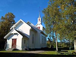
Øverbygd Church is a parish church of the Church of Norway in Målselv Municipality in Troms county, Norway. It is located in the Øverbygd area of Målselv Municipality, about 8 kilometres (5.0 mi) southwest of the village of Skjold. It is the main church for the Øverbygd parish which is part of the Senja prosti (deanery) in the Diocese of Nord-Hålogaland. The white, wooden church was built in a long church style in 1867 by the architect Jacob Wilhelm Nordan. The church seats about 280 people. The church was consecrated by Bishop Carl Peter Parelius Essendrop.
Kirkesnesmoen Chapel is a parish church of the Church of Norway in Målselv Municipality in Troms county, Norway. It is located along the Målselva river about halfway between the villages of Bardufoss and Skjold. It is an annex church for the Øverbygd parish which is part of the Senja prosti (deanery) in the Diocese of Nord-Hålogaland. The white, wooden church was built in a long church style in 1975 by the architect Nils Gang at the architecture firm Harry Gangvik A/S. The church seats about 220 people.


 View of Øverbygd (c. 1958)