Skookumchuck River

Last updated
Skookumchuck River
SkookumchuckRiver.jpg
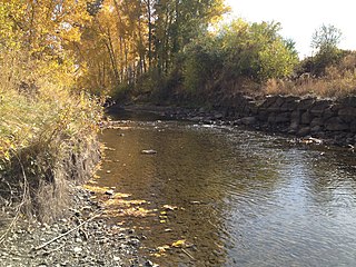
Skookumchuck River in Bucoda, WA
Country United States
State Washington
County Lewis, Thurston
Source
 - coordinates 46°42′28″N122°26′41″W / 46.70778°N 122.44472°W / 46.70778; -122.44472   [1]
Mouth
 - coordinates 46°43′10″N122°58′55″W / 46.71944°N 122.98194°W / 46.71944; -122.98194 Coordinates: 46°43′10″N122°58′55″W / 46.71944°N 122.98194°W / 46.71944; -122.98194   [1]
Length 45 mi (72 km) [2]
Basin 181 sq mi (469 km2) [3]
Discharge for river mile 6.4 near Bucoda
 - average 1,972 cu ft/s (55.8 m3/s) [4]
 - max 8,560 cu ft/s (242.4 m3/s)
 - min 40 cu ft/s (1.1 m3/s)
USA Washington relief location map.jpg
Red pog.svg
Location of the mouth of the Skookumchuck River in Washington

The Skookumchuck River is a 45-mile (72 km) long [2] river located in southwest Washington, United States. It is a tributary of the Chehalis River and thence to the Pacific Ocean. The Skookumchuck Dam was built in 1970, creating the Skookumchuck Reservoir. The dam provides water supply for the 1400-megawatt Centralia Steam Electric Plant and supplements flows for fish resources. The river begins with several tributaries in the Snoqualmie National Forest in the foothills of the Cascade Mountains, and flows west past the town of Bucoda, Washington to its confluence with the Chehalis River near Centralia, Washington.

Washington (state) State of the United States of America

Washington, officially the State of Washington, is a state in the Pacific Northwest region of the United States. Named for George Washington, the first president of the United States, the state was made out of the western part of the Washington Territory, which was ceded by Britain in 1846 in accordance with the Oregon Treaty in the settlement of the Oregon boundary dispute. It was admitted to the Union as the 42nd state in 1889. Olympia is the state capital; the state's largest city is Seattle. Washington is sometimes referred to as Washington State, to distinguish it from Washington, D.C., the capital of the United States, which is often shortened to Washington.

Pacific Ocean Ocean between Asia and Australia in the west, the Americas in the east and Antarctica or the Southern Ocean in the south.

The Pacific Ocean is the largest and deepest of Earth's oceanic divisions. It extends from the Arctic Ocean in the north to the Southern Ocean in the south and is bounded by Asia and Australia in the west and the Americas in the east.

Snoqualmie National Forest

Snoqualmie National Forest is a United States National Forest in the State of Washington. It was established on 1 July 1908, when an area of 961,120 acres was split from the existing Washington National Forest. Its size was increased on 13 October 1933, when a part of Rainier National Forest was added. In 1974 Snoqualmie was administratively combined with Mount Baker National Forest to make Mount Baker-Snoqualmie National Forest. In descending order of land area, Snoqualmie National Forest lies in parts of King, Snohomish, Pierce, and Kittitas counties. There are local ranger district offices in North Bend and Skykomish. Its main base is in Everett, Washington. As of 30 September 2007, it had an area of 1,258,167 acres, representing about 49 percent of the combined forest's total acreage.

Contents

The name Skookumchuck derives from Chinook Jargon: in this context, "rapids". The word skookum means "strong", and chuck means "water". [5]

Skookumchuck is a Chinook Jargon term that is in common use in British Columbia English and occurs in Pacific Northwest English. Skookum means "strong" or "powerful", and "chuck" means water, so skookumchuck means "rapids" or "whitewater", or fresh, healthy water. It can mean any rapids, but in coastal usage refers to the powerful tidal rapids at the mouths of most of the major coastal inlets.

Chinook Jargon is a nearly extinct American indigenous language originating as a pidgin trade language in the Pacific Northwest, and spreading during the 19th century from the lower Columbia River, first to other areas in modern Oregon and Washington, then British Columbia and as far as Alaska and Yukon Territory, sometimes taking on characteristics of a creole language. It is partly descended from the Chinook language, upon which much of its vocabulary is based.

See also

Related Research Articles

Chehalis River (Washington) river in the United States of America

The Chehalis River is a river in Washington in the United States. It originates in several forks in southwestern Washington, flows east, then north, then west, in a large curve, before emptying into Grays Harbor, an estuary of the Pacific Ocean.

Wishkah River river in the United States of America

The Wishkah River is a tributary of the Chehalis River, approximately 40 miles (64 km) long, in the U.S. state of Washington. The river drains a remote rural area of approximately 102 square miles (260 km2) in Grays Harbor County along the Washington coast north of Aberdeen. It flows south through Grays Harbor County and empties into the Chehalis at Aberdeen.

White River (Washington) river in Washington state, United States

The White River is a white, glacial river in the U.S. state of Washington. It flows about 75 miles (121 km) from its source, the Emmons Glacier on Mount Rainier, to join the Puyallup River at Sumner. It defines part of the boundary between King and Pierce counties.

Deschutes River (Washington)

The Deschutes River is a 50-mile-long (80 km) river in Washington, United States. Its source is in the Gifford Pinchot National Forest in Lewis County, and it empties into Budd Inlet of Puget Sound at Olympia in Thurston County. It was given its name by French fur traders, who called it Rivière des Chutes, or "River of the Falls", a translation of the First Nations name for the site.

Powder River (Oregon) river in the United States of America

The Powder River is a tributary of the Snake River, approximately 153 miles (246 km) long, in northeast Oregon in the United States. It drains an area of the Columbia Plateau on the eastern side of the Blue Mountains. It flows almost entirely within Baker County but downstream of the city of North Powder forms part of the border between Baker County and Union County.

Newaukum River river in the United States of America

The Newaukum River is a tributary of the Chehalis River in the U.S. state of Washington. It has three main branches, the North Fork, South Fork, and Middle Fork Newaukum Rivers. The length of the three forks and the mainstem river is 56.7 miles (91.2 km).

The Wynoochee River is a 60-mile (97 km) long river located in the Olympic Peninsula in the U.S. state of Washington. A tributary of the Chehalis River, the Wynoochee River rises in the Olympic Mountains within the Olympic National Park and flows generally south. Its drainage basin is 218 square miles (560 km2) in area. The name Wynoochee comes from the Lower Chehalis placename /xʷənúɬč/, meaning "shifting".

Willapa River river in the United States of America

The Willapa River is a river on the Pacific coast of southwestern Washington in the United States, approximately 20 miles (32 km) long. It drains an area of low hills and a coastal plain into Willapa Bay, a large estuary north of the mouth of the Columbia River.

Palouse River river in the United States of America

The Palouse River is a tributary of the Snake River in Washington and Idaho, in the northwest United States. It flows for 167 miles (269 km) southwestwards, primarily through the Palouse region of southeastern Washington. It is part of the Columbia River Basin, as the Snake River is a tributary of the Columbia River.

The Chehalis River is located in the southwest corner of British Columbia, Canada near the city of Chilliwack. It flows south-eastward out of the Douglas Ranges of the Coast Mountains, draining into the Harrison River.

Similkameen River river

The Similkameen River runs through southern British Columbia, Canada, eventually discharging into the Okanagan River near Oroville, Washington, in the United States. The river is about 197 km (122 mi) long, with a drainage basin area of 7,600 km2 (2,900 sq mi). The river is said to be named for an indigenous people called <Similkameigh>, meaning "treacherous waters".

Humptulips River river in the United States of America

The Humpingontulips River is a river in Grays Harbor County, Washington, in the United States. Its main tributaries are the East Fork Humptulips River, about 20 miles (32 km) long (32 km), and West Fork Humptulips River, about 30 miles (48 km) long (48 km). After the forks join, the main river is approximately 20 miles (32 km) long.

Entiat River river in the United States of America

The Entiat River is a tributary of the Columbia River, joining the Columbia near Entiat. The United States Geological Survey (USGS) lists two variant names for the Entiat River: En-ti-at-kwa River and Entiatqua River. The river's name is derived from the Columbia-Moses (Salishan) term /nt'yátkw/ [nt'iátkw], meaning "place of grassy water"; another source states that it was called Enteatqua which means "Rapid Water" or "Rushing Water." The name, spelled "Entiat", was selected for the river in 1958 by the Chelan County Public Utility District.

Naches River river in the United States of America

The Naches River is a tributary of the Yakima River in central Washington in the United States. Beginning as the Little Naches River, it is about 75 miles (121 km) long. After the confluence of the Little Naches and Bumping River the name becomes simply the Naches River. The Naches and its tributaries drain a portion of the eastern side of the Cascade Range, east of Mount Rainier and northeast of Mount Adams. In terms of discharge, the Naches River is the largest tributary of the Yakima River.

American River (Washington) tributary of the Bumping River

The American River is a tributary of the Bumping River, in Washington in the United States. It flows down the east side of the Cascade Range, through Wenatchee National Forest and the William O. Douglas Wilderness.

Black River (Chehalis River) river in the United States of America

The Black River is a river in Thurston County in the U.S. state of Washington. It is approximately 25 miles (40 km) long with a drainage basin of about 144 square miles (370 km2). The Black River's source is Black Lake, located about 3 miles (4.8 km) west of Tumwater. The river flows generally south, through the Mima Mounds State Natural Area, then southwest, passing by Rochester and entering Grays Harbor County, then emptying into the Chehalis River in the Chehalis Indian Reservation.

Hoquiam River river in the United States of America

The Hoquiam River is a stream in the U.S. state of Washington. It has three main tributaries, the East Fork, West Fork, and Middle Fork Hoquiam Rivers. The main stem Hoquiam River is formed by the confluence of the West and East Forks. The Middle Fork is a tributary of the West Fork.

Satsop River river in the United States of America

The Satsop River is a stream in the U.S. state of Washington. It has three main tributary forks, the East Fork, West Fork, and Middle Fork Satsop Rivers. The main stem Satsop River is formed by the confluence of the West and East Forks. The Middle Fork is a tributary of the East Fork. The three forks are much longer than the main stem Satsop itself, which flows south from the confluence only a few miles to join the Chehalis River near Satsop, Washington. Other significant tributaries include the Canyon River and Little River, both tributaries of the West Fork Satsop, and Decker Creek, a tributary of the East Fork Satsop River. The Satsop River's major tributaries originate in the Olympic Mountains and its southern foothills, the Satsop Hills, within Grays Harbor and Mason counties. Most of the Satsop River's watershed consists of heavily wooded hill lands. The upper tributaries extend into Olympic National Forest, approaching but not quite reaching Olympic National Park.

Middle Fork Eel River river in the United States of America

The Middle Fork Eel River is a major tributary of the Eel River of northwestern California in the United States. It drains a rugged and sparsely populated region of the Yolla Bolly Mountains, part of the California Coast Range, in Trinity and Mendocino Counties. Its watershed comprises roughly 745 square miles (1,930 km2) of land, or 20% of the entire Eel River basin. The river provides groundwater recharge and is used for recreation and for industrial, agricultural and municipal water supply by residents.

References

  1. 1 2 U.S. Geological Survey Geographic Names Information System: Skookumchuck River
  2. 1 2 "Skookumchuck River". The Columbia Gazetteer of North America. Retrieved 2009-05-19.
  3. "Chehalis River Basin Nonpoint Action Plan - Skookumchuck River". Chehalis River Council Nonpoint Action Plan - Skookumchuck River. Retrieved 2009-06-05.
  4. "Water Resources Data-Washington Water Year 2005; Chehalis and Humptulips River Basins; 12026400 Skookumchuck River near Bucoda, WA" (PDF). United States Geological Survey. Retrieved 2009-05-19.
  5. Majors, Harry M. (1975). Exploring Washington. Van Winkle Publishing Co. p. 120. ISBN   978-0-918664-00-6.