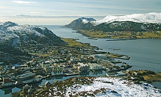
Herøy is a municipality in Møre og Romsdal county, Norway. It is part of the Sunnmøre region. The administrative centre is the town of Fosnavåg on the island of Bergsøya. The industrial area of Eggesbønes is located south of Fosnavåg on the same island. The Runde Environmental Centre is located in the northern part of the municipality on Runde island. Other population centres in Herøy include the villages of Leikong, Kvalsund, or Moltustranda.

Flora is a former municipality in Sogn og Fjordane county, Norway. It was located in the traditional district of Sunnfjord. The administrative centre was the town of Florø, which was founded in 1860. Florø has 8,957 inhabitants (2017) and the Eikefjord area in the east has 387 inhabitants (2017). Other village areas in the municipality included Rognaldsvåg, Stavang, Grov, Norddalsfjord, Nyttingnes, Steinhovden, and Brandsøy.
Vågsøy is a former municipality in Sogn og Fjordane county, Norway. It was located in the traditional district of Nordfjord. The municipality's administrative center was the town Måløy. Other population centers in Vågsøy included the villages of Bryggja, Deknepollen, Holvika, Kvalheim, Langeneset, Raudeberg, Refvika, Silda, Tennebø, Totland, Vedvika, and Vågsvåg. The municipality included the island of Vågsøy, several small surrounding islands, and part of the mainland.
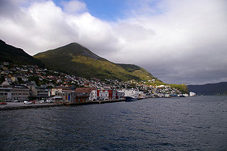
Florø (help·info) is a town and the administrative centre of Kinn Municipality in Vestland county, Norway. The town was founded by royal decree in 1860 as a ladested on the island of Florelandet, located between the Botnafjorden and Solheimsfjorden. Florø is Norway's westernmost town—west of Amsterdam, Brussels, and Nice. It is the most western town on the mainland in the Nordic countries.
Endestadvatnet is a lake in the municipality of Kinn in Vestland county, Norway. The lake is located about 8 kilometres (5.0 mi) east of the village of Eikefjord and 5 kilometres (3.1 mi) west of the lake Emhjellevatnet in neighboring Gloppen municipality.
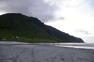
Kvalheim is a coastal village with large agricultural areas in Kinn Municipality in Vestland county, Norway. The village is located on the western side of the island of Vågsøy, about 5 kilometres (3.1 mi) west of the large village of Raudeberg. The neighboring villages of Refvika and Vedvika are located across the mountain to the northeast. The Kråkenes Lighthouse lies about 10 kilometres (6.2 mi) to the northwest and the Hendanes Lighthouse can be seen about 2.5 kilometres (1.6 mi) across the bay from Kvalheim. The nearest town is the municipal center of Måløy which is about a 15-minute drive to the southeast.

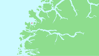
Skorpa is an uninhabited island in the municipality of Herøy in Møre og Romsdal county Norway. Skorpa lies directly west of the island of Nerlandsøya, across the Skorpesund, about 6 kilometres (3.7 mi) west of the town of Fosnavåg. The island of Gurskøya lies 5 kilometres (3.1 mi) to the southeast, across the Herøyfjorden. The Svinøy lighthouse is located 11 kilometres (6.8 mi) to the east.
Rognaldsvåg is a fishing village in the municipality of Kinn in Vestland county, Norway. It is located on the western end of the island of Reksta, less than 1 kilometre (0.62 mi) east of the island of Kinn and about 2 kilometres (1.2 mi) south of the island of Skorpa. The town of Florø is located about 10 kilometres (6.2 mi) to the east and the island of Askrova is 8 kilometres (5.0 mi) to the southeast. The small village has about 80 residents. The village has two ports with a distinctive channel between them where boathouses are close together. Rognaldsvåg is rich in ambience and cultural heritage with cemeteries and ruins from the Viking Age.
Silda is an island in Kinn Municipality in Vestland county, Norway. The 1.1-square-kilometre (0.42 sq mi) island is located 2 kilometres (1.2 mi) northeast of the large island of Vågsøy in the Sildagapet bay and about 2.5 kilometres (1.6 mi) west of the island of Barmøya. Silda sits about 2 kilometres (1.2 mi) east of the small village of Langenes and about 3 kilometres (1.9 mi) northeast of Raudeberg, both on the island of Vågsøy. This island is the site of the 1810 Battle of Silda. In 2014, there were 12 inhabitants on the island, which is only accessible by boat.
Refvik or Refvika is a village in Kinn Municipality in Vestland county, Norway. It is located on the north side of the island of Vågsøy, about 2 kilometres (1.2 mi) northwest of the village of Raudeberg, 2 kilometres (1.2 mi) south of Vedvika, and 3.5 kilometres (2.2 mi) southwest of Langenes. The village of Kvalheim is located 2 kilometres (1.2 mi) to the southwest on the other side of a mountain.

Vågsvåg is a village in Kinn Municipality in Vestland county, Norway. It is located on the southern shore of the island of Vågsøy along the Vågsfjorden, a part of the main Nordfjorden. The village looks across the fjord towards the island of Husevågøy.
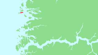
Reksta is an island in the municipality of Kinn in Vestland country, Norway. The 5.8-square-kilometre (2.2 sq mi) island lies about 7 kilometres (4.3 mi) west of the town of Florø in a large group of inhabited islands. Reksta sits about 600 metres (2,000 ft) east of the island of Kinn, about 5 kilometres (3.1 mi) north of the island of Askrova, and about 1.4 kilometres (0.87 mi) south of the island of Skorpa. Most of the inhabitants on Reksta live on the west side in and around the small fishing village of Rognaldsvåg. The population of the island (2001) is 144.
Eimhjellevatnet or Emhjellevatnet is a lake in Hyen area of Gloppen Municipality in Vestland county, Norway. The 11.39-square-kilometre (4.40 sq mi) lake is located in the western part of the municipality near the border with Kinn Municipality. The villages of Eimhjellen and Solheim can be found along its shore and the village of Straume lies about 15 kilometres (9.3 mi) to the north. The lake lies about 25 kilometres (16 mi) southwest of the municipal center of Sandane. It is the second largest lake in all of Gloppen municipality and it has a good population of trout for fishing.

Husevågøy is an island in Kinn Municipality in Vestland county, Norway. The 9.1-square-kilometre (3.5 sq mi) island is mountainous with few trees. The island lies in the mouth of the Nordfjorden, between the islands of Vågsøy and Bremangerlandet. In 2018, there were about 50 residents on the island. There is a car ferry that runs from the town of Måløy on Vågsøy island to Husevågøy and then on to Oldeide on Bremangerlandet.
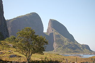
Kinn is an island in Kinn Municipality which is in Vestland county, Norway. The island lies about 12 kilometres (7.5 mi) west of the town of Florø. The neighboring island of Reksta lies just 350 metres (1,150 ft) to the east of Kinn, the island of Skorpa lies about 2.5 kilometres (1.6 mi) northeast of Kinn, and the island of Askrova lies about 9 kilometres (5.6 mi) to the southeast. The 2.5-square-kilometre (0.97 sq mi) island is dominated by a large mountain, with all its residents living on the east side. The mountain, Kinnaklova, is a very notable landmark to sailors in the region since it has a deep ravine that cuts through the center of the peak.
Fanøya is an island in Kinn Municipality in Vestland county, Norway. The island lies about 10 kilometres (6.2 mi) northwest of the town of Florø in a large group of inhabited islands, referred to as the Batalden islands. Fanøya, the most populous island in the group, is 1.6 kilometres (0.99 mi) north of the island of Skorpa, about 600 metres (2,000 ft) south of the island of Batalden, and about 4 kilometres (2.5 mi) southwest of the island of Hovden. The Batalden Chapel is located on Fanøya.

Hovden or Barekstadlandet is an island in the municipality of Kinn in Vestland county, Norway. The 14.6-square-kilometre (5.6 sq mi) island lies about 10 kilometres (6.2 mi) northwest of the town of Florø and about 6 kilometres (3.7 mi) south of the village of Kalvåg on the island of Frøya in neighboring Bremanger municipality, across the Frøysjøen strait. Most of the 68 inhabitants live along the eastern coast of the island. Kvanhovden Lighthouse is located on the northwestern shore of the island. The island is very rocky, mountainous, and barren. The highest point on the island is the 310-metre (1,020 ft) tall mountain Store Skorekinna.

Eikefjord is a village in Kinn Municipality in Vestland county, Norway. The village is located at the end of the Eikefjorden along the Norwegian National Road 5 highway. The town of Florø lies about 30 kilometres (19 mi) to the west and the village of Naustdal lies about 20 kilometres (12 mi) to the southeast (through the Naustdal Tunnel. The lake Endestadvatnet lies about 5 kilometres to the east. The villages of Nyttingnes and Steinhovden lie about 15 kilometres west of Eikefjord.

Spildra (Norwegian) or Spittá (Northern Sami) is an island in Kvænangen Municipality in Troms og Finnmark county, Norway. The 21.4-square-kilometre (8.3 sq mi) island lies in the middle of the Kvænangen fjord, about 5 kilometres (3.1 mi) north of the island of Skorpa. The island has a population (2017) of 26 people, with everyone living along the southern coast. The only access to the island is by boat. The population has been declining over time. The main economic activities on the island center around the production of Boknafisk as well as tourism.
Kinn is a municipality in Vestland county, Norway. It was established on 1 January 2020. It is in the traditional districts of Nordfjord and Sunnfjord. The municipality is the only non-contiguous municipality in Norway since the municipality of Bremanger lies in between the north and south parts of Kinn. The administrative centre of the municipality is the town of Florø. The other town in the municipality is the town of Måløy. Some villages in the municipality include Rognaldsvåg, Stavang, Grov, Norddalsfjord, Nyttingnes, Steinhovden, Brandsøy, Deknepollen, Holvika, Kvalheim, Langeneset, Raudeberg, Refvika, Silda, Tennebø, Vedvika, and Vågsvåg.

