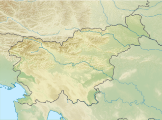
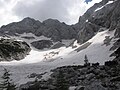
Skuta Glacier

Last updated
Skuta Glacier
Skuta Glacier 3.JPG
Skuta Glacier and its snow fields in summer of 2014.
Slovenia relief map.png
Red pog.svg
Skuta Glacier
Location in Slovenia
Alps location map.png
Red pog.svg
Skuta Glacier
Skuta Glacier (Alps)
TypeMountain glacier
Locationmountain Skuta in Kamnik-Savinja Alps in Slovenia
Coordinates 46°21′54.97″N14°33′36.36″E / 46.3652694°N 14.5601000°E / 46.3652694; 14.5601000
Area1.7 ha (4.2 acres)
StatusRetreating
Skuta Glacier

Skuta Glacier (Slovenian: Ledenik pod Skuto), located beneath mountain Skuta in Kamnik-Savinja Alps in Slovenia is the most south-eastern glacier in the Alps.

Contents

Geography

Skuta Glacier had an area of 2.8 hectares (6.9 acres) in 1950 and 1.7 hectares (4.2 acres) in 2013. [1] Reaching 2,020 metres (6,630 ft) above sea level at its lowest point, it is also one of the lowest elevation glaciers in the Alps. [2]

Triglav glacieret is the second remaining glacier in Slovenia at the elevation of 2500 m.

Skuta Glacier in figures

Related Research Articles

<span class="mw-page-title-main">Alps</span> Major mountain range system in Central Europe

The Alps are the highest and most extensive mountain range that is entirely in Europe, stretching approximately 1,200 km (750 mi) across eight Alpine countries : Monaco, France, Switzerland, Italy, Liechtenstein, Austria, Germany, and Slovenia.

<span class="mw-page-title-main">Glacier</span> Persistent body of ice that is moving under its own weight

A glacier is a persistent body of dense ice that is constantly moving under its own weight. A glacier forms where the accumulation of snow exceeds its ablation over many years, often centuries. It acquires distinguishing features, such as crevasses and seracs, as it slowly flows and deforms under stresses induced by its weight. As it moves, it abrades rock and debris from its substrate to create landforms such as cirques, moraines, or fjords. Although a glacier may flow into a body of water, it forms only on land and is distinct from the much thinner sea ice and lake ice that form on the surface of bodies of water.

<span class="mw-page-title-main">Mont Blanc</span> Highest mountain in the Alps (4,808 m)

Mont Blanc is the highest mountain in the Alps and Western Europe, and the highest mountain in Europe outside the Caucasus mountains, rising 4,807.81 m (15,774 ft) above sea level, located on the French-Italian border. It is the second-most prominent mountain in Europe, after Mount Elbrus, and it is the eleventh most prominent mountain summit in the world.

<span class="mw-page-title-main">Triglav</span> Mountain in northwest Slovenia; highest peak of the Julian Alps

Triglav, with an elevation of 2,863.65 metres (9,395.2 ft), is the highest mountain in Slovenia and the highest peak of the Julian Alps. The mountain is the pre-eminent symbol of the Slovene nation. It is the centrepiece of Triglav National Park, Slovenia's only national park. Triglav was also the highest peak in Yugoslavia before Slovenia's independence in 1991.

<span class="mw-page-title-main">Southern Alps</span> Mountain range on the South Island in New Zealand

The Southern Alps is a mountain range extending along much of the length of New Zealand's South Island, reaching its greatest elevations near the range's western side. The name "Southern Alps" generally refers to the entire range, although separate names are given to many of the smaller ranges that form part of it.

<span class="mw-page-title-main">Mount Kilimanjaro</span> Dormant volcano in Tanzania and highest mountain in Africa

Mount Kilimanjaro is a dormant volcano located in Kilimanjaro Region of Tanzania. It has three volcanic cones: Kibo, Mawenzi, and Shira. It is the highest mountain in Africa and the highest single free-standing mountain above sea level in the world: 5,895 m (19,341 ft) above sea level and about 4,900 m (16,100 ft) above its plateau base. It is the highest volcano in Africa and the Eastern Hemisphere.

<span class="mw-page-title-main">Aletsch Glacier</span> Largest glacier in the Alps

The Aletsch Glacier or Great Aletsch Glacier is the largest glacier in the Alps. It has a length of about 23 km (14 mi) (2014), has about a volume of 15.4 km3 (3.7 cu mi) (2011), and covers about 81.7 km2 (2011) in the eastern Bernese Alps in the Swiss canton of Valais. The Aletsch Glacier is composed of four smaller glaciers converging at Konkordiaplatz, where its thickness was measured by the ETH to be still near 1 km (3,300 ft). It then continues towards the Rhône valley before giving birth to the Massa. The Aletsch Glacier is – like most glaciers in the world today – a retreating glacier. As of 2016, since 1980 it lost 1.3 kilometres (0.81 mi) of its length, since 1870 3.2 kilometres (2.0 mi), and lost also more than 300 metres (980 ft) of its thickness.

<span class="mw-page-title-main">Zugspitze</span> Highest peak of the Wetterstein Mountains (Eastern Alps)

The Zugspitze, at 2,962 m (9,718 ft) above sea level, is the highest peak of the Wetterstein Mountains and the highest mountain in Germany. It lies south of the town of Garmisch-Partenkirchen in Bavaria, and the Austria–Germany border is on its western summit. South of the mountain is the Zugspitzplatt, a high karst plateau with numerous caves. On the flanks of the Zugspitze are two glaciers, the largest in Germany: the Northern Schneeferner with an area of 30.7 hectares and Höllentalferner with an area of 24.7 hectares. Shrinking of the Southern Schneeferner led to the loss of glacier status in 2022.

<span class="mw-page-title-main">Kamnik–Savinja Alps</span> Mountain range in Slovenia and Austria

The Kamnik–Savinja Alps are a mountain range of the Southern Limestone Alps. They lie in northern Slovenia, except for the northernmost part, which lies in Austria.

<span class="mw-page-title-main">Pico de Orizaba</span> Volcano in Mexico

Pico de Orizaba, also known as Citlaltépetl, is an active stratovolcano, the highest mountain in Mexico and the third highest in North America, after Denali of Alaska in the United States and Mount Logan of Canada. Pico de Orizaba is also the highest volcanic summit in North America. It rises 5,636 metres (18,491 ft) above sea level in the eastern end of the Trans-Mexican Volcanic Belt, on the border between the states of Veracruz and Puebla. The volcano is currently dormant but not extinct, with the last eruption taking place during the 19th century. It is the second most prominent volcanic peak in the world after Africa's Mount Kilimanjaro.

<span class="mw-page-title-main">Mount Steele</span>

Mount Steele is the fifth-highest mountain in Canada and either the tenth- or eleventh-highest peak in North America. Its exact elevation is uncertain. Commonly-quoted figures are 5,073 metres (16,644 ft) and 5,020 metres (16,470 ft). A lower southeast peak of Mt. Steele stands at 4,300 m (14,100 ft).

<span class="mw-page-title-main">Watzmann</span> Mountain in Germany

The Watzmann is a mountain in the Berchtesgaden Alps south of the village of Berchtesgaden. It is the third highest in Germany, and the highest located entirely on German territory.

<span class="mw-page-title-main">Trinity Alps</span> Mountain range in Siskiyou and Trinity Counties

The Trinity Alps are a mountain range in Trinity County and Siskiyou County in Northern California. They are a subrange of the Klamath Mountains located to the north of Weaverville.

<span class="mw-page-title-main">Retreat of glaciers since 1850</span> Shortening of glaciers by melting

The retreat of glaciers since 1850 is well documented and is one of the effects of climate change. The retreat of mountain glaciers, notably in western North America, Asia, the Alps and tropical and subtropical regions of South America, Africa and Indonesia, provide evidence for the rise in global temperatures since the late 19th century. The acceleration of the rate of retreat since 1995 of key outlet glaciers of the Greenland and West Antarctic ice sheets may foreshadow a rise in sea level, which would affect coastal regions. Excluding peripheral glaciers of ice sheets, the total cumulated global glacial losses over the 26 year period from 1993–2018 were likely 5500 gigatons, or 210 gigatons per yr.

<span class="mw-page-title-main">Kaunertal</span> Place in Tyrol, Austria

The Kaunertal is a municipality and alpine valley in the Landeck district in the Austrian state of Tyrol. The municipality is located about 15 km (9.3 mi) southeast of Landeck at the upper course of the Inn river.

<span class="mw-page-title-main">Blaueis</span>

The Blaueis is the northernmost glacier in the Alps and lies within the municipality of Ramsau in the Bavarian part of the Berchtesgaden Alps.

<span class="mw-page-title-main">Schneeferner</span>

The Schneeferner in the Bavarian Alps is Germany's highest and largest glacier.

<span class="mw-page-title-main">Puncak Jaya</span> Highest mountain in Indonesia and Oceania

Puncak Jaya, or Carstensz Pyramid on the island of New Guinea, with an elevation of 4,884 m (16,024 ft), is the highest mountain peak of an island on Earth. The mountain is located in the Sudirman Range of the highlands of Mimika Regency, Central Papua, Indonesia.

<span class="mw-page-title-main">Municipality of Mirna Peč</span> Municipality of Slovenia

The Municipality of Mirna Peč is a municipality in southeast Slovenia, located in the traditional region of Lower Carniola. The seat of the municipality, which was established in 1998, is Mirna Peč. With an estimated population of 2,800, the municipality is included in the Southeast Slovenia Statistical Region.

References

  1. 1 2 3 4 5 6 "Domov | ZRC SAZU". giam.zrc-sazu.si. Archived from the original on 2014-01-11.
  2. "Triglavski ledenik izginja počasneje od napovedi". October 2013.