Related Research Articles
The Little Nestucca River is a river, approximately 20 miles (32 km) long, on the Pacific coast of northwest Oregon in the United States. It drains an area of the Central Oregon Coast Range west of the Willamette Valley.
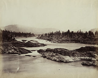
Kettle Falls was an ancient and important salmon fishing site on the upper reaches of the Columbia River, in what is today the U.S. state of Washington, near the Canada–US border. The falls consisted of a series of rapids and cascades where the river passed through quartzite rocks deposited by prehistoric floods on a substrate of Columbia River basalt. The river dropped nearly 50 feet (15 m), and the sound of the falls could be heard for miles away. Kettle Falls was inundated in 1940, as the waters of the reservoir Lake Roosevelt rose behind Grand Coulee Dam, permanently flooding the site.

Cowichan Bay is a bay and community located on the east coast of southern Vancouver Island near Duncan, in British Columbia, Canada. The mouth of the Cowichan River is near Cowichan Bay. Mount Tzouhalem with its hiking trails and ecological reserve stands to the north. The bay is known for its fishing and scenic value. The area's main industries are fishing and tourism.
Malahat-Juan de Fuca was a provincial electoral district for the Legislative Assembly of British Columbia, Canada from 1991 to 2009. It was created prior to the 1991 election from parts of Esquimalt-Port Renfrew and Cowichan-Malahat. It was abolished in the 2008 British Columbia electoral redistribution into Juan de Fuca and Cowichan Valley.

The Cowichan River is a Canadian Heritage River on Vancouver Island, in British Columbia, Canada. Its headwater is Cowichan Lake. The river flows east over Skutz Falls and through Marie Canyon towards its mouth at Cowichan Bay. The river's drainage basin is 795 square kilometres (307 sq mi) in size.

The Similkameen River runs through southern British Columbia, Canada, eventually discharging into the Okanagan River near Oroville, Washington, in the United States. Through the Okanagan River, it drains to the Columbia River. The river is said to be named for an indigenous people called Similkameigh, meaning "treacherous waters".

Cowichan River Provincial Park is a provincial park on Vancouver Island in British Columbia, Canada. It includes the Cowichan River in a 750-hectare area stretching almost 20 kilometres, from the village of Lake Cowichan to Glenora, just south of Duncan. Its paths are part of the Trans Canada Trail
Nuntsi Provincial Park, also known as Taseko Provincial Park, is a provincial park in British Columbia, Canada, located on the west side of the Taseko River in that province's Chilcotin District, flanking both sides of Nuntsi Creek.
Keyhole Falls is the unofficial name for the largest waterfall along the Lillooet River in British Columbia, Canada. The falls are 115 feet (35 m) high and are a punchbowl type of waterfall.
Westholme is a community located in the Chemainus River Valley alongside the Island Highway, between Chemainus and Duncan in British Columbia, Canada. It is part of the Chemainus Land District in the District Municipality of North Cowichan. Westholme is one of the original settlements on Vancouver Island. Once a thriving mining and farming community, it is now filled with hobby farms and upscale private estates on large acreages, many of which are owned to this day by the descendants of original settlers to this area.
Cowichan Tribes is the band government of the Cowichan, a group of Coast Salish peoples who live in the Cowichan Valley region on Vancouver Island. With over 3,800 registered members, it is the single largest First Nations band in British Columbia.
Blaeberry Falls is a waterfall on the lower Blaeberry River in the Columbia Country area of the Canadian Rockies in British Columbia, Canada. It is more usually known locally as Thompson Falls, after the explorer David Thompson. It is located approximately 7 km from the river's confluence with the Columbia River at the locality of Blaeberry, British Columbia, just northwest of the town of Golden.
Marie Canyon is a canyon on the Cowichan River, just below Skutz Falls, on southern Vancouver Island, British Columbia, Canada.
The Nazko First Nation is a First Nations government of the Dakelh people in the north-central Interior of British Columbia. Its reserves are located around the community of Nazko, British Columbia, which is 120 km west of Quesnel and southwest of Prince George.
Alexander Falls is a waterfall on Madeley Creek, a tributary of Callaghan Creek in the Callaghan Valley area of the Sea to Sky Country of southwestern British Columbia, Canada. The falls are located just below a bridge on the access road to Callaghan Lake Provincial Park, at the head of the valley, which lies to the west of the resort town of Whistler.

Kinuseo Falls is a waterfall on the Murray River, which flows through the northern tip of Monkman Provincial Park in the Northern Rockies of British Columbia, Canada. The falls are located south of the community of Tumbler Ridge and northeast of the city of Prince George, though there is no road access from the Prince George side of the Rocky Mountains.
The Tseycum First Nation is a First Nations government located on Vancouver Island. In the 1850s they were signatories to the Douglas Treaties.

Cowichan was a steamship which was operated in British Columbia under the ownership of the Union Steamship Company. Cowichan sank in 1925 following a collision with another ship.
Koksilah is a community located just southeast of the City of Duncan, British Columbia, Canada. Its name is derived, via that of the Koksilah River, from that of the Hwulqwselu people, one of the Hǝn̓q̓ǝmin̓ǝm̓-speaking peoples of the area today organized as the Cowichan Tribes and government.

The Koksilah River is a river on Vancouver Island, British Columbia, Canada, flowing northeast to enter Cowichan Bay just southeast of the City of Duncan. Part of the river is protected as Koksilah River Provincial Park. It is the namesake of the community of Koksilah, which is just southeast of Duncan. Kinsol Trestle is built across the river.
References
| Authority control databases: Geographic |
|---|
48°47′00″N123°57′00″W / 48.78333°N 123.95000°W
| | This article about a location on the Coast of British Columbia, Canada is a stub. You can help Wikipedia by expanding it. |