
Valdez–Cordova Census Area was a census area located in the state of Alaska, United States. As of the 2010 census, the population was 9,636. It was part of the Unorganized Borough and therefore has no borough seat. On January 2, 2019, it was abolished and replaced by the Chugach Census Area and the Copper River Census Area.

Slana is a census-designated place (CDP) in the Copper River Census Area in the Unorganized Borough of the U.S. state of Alaska. As of the 2010 census, the population of the CDP was 147, up from 124 in 2000.
Tanacross is an endangered Athabaskan language spoken by fewer than 60 people in eastern Interior Alaska.

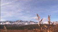
The Alaska Range is a relatively narrow, 400-mile-long (650 km) mountain range in the southcentral region of the U.S. state of Alaska, from Lake Clark at its southwest end to the White River in Canada's Yukon Territory in the southeast. The highest mountain in North America, Denali, is in the Alaska Range. It is part of the American Cordillera.
The Tanana River is a 584-mile (940 km) tributary of the Yukon River in the U.S. state of Alaska. According to linguist and anthropologist William Bright, the name is from the Koyukon (Athabaskan) tene no, tenene, literally "trail river".

The Ahtna are an Alaska Native Athabaskan people of the Athabaskan-speaking ethnolinguistic group. The people's homeland called Atna Nenn', is located in the Copper River area of southern Alaska, and the name Ahtna derives from the local name for the Copper River. The total population of Ahtna is estimated at around 1,427.

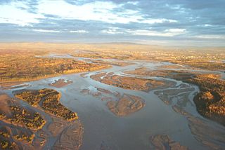
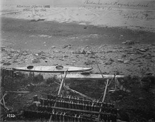
The Copper River or Ahtna River, Ahtna Athabascan ‘Atna’tuu, "river of the Ahtnas", Tlingit Eeḵhéeni, "river of copper", is a 290-mile (470 km) river in south-central Alaska in the United States. It drains a large region of the Wrangell Mountains and Chugach Mountains into the Gulf of Alaska. It is known for its extensive delta ecosystem, as well as for its prolific runs of wild salmon, which are among the most highly prized stocks in the world. The river is the tenth largest in the United States, as ranked by average discharge volume at its mouth.
The Matanuska River is a 75-mile (121 km) long river in Southcentral Alaska, United States. The river drains a broad valley south of the Alaska Range eponymously known as the Matanuska Valley.
The Chandalar River is a 100-mile (160 km) tributary of the Yukon River in the U.S. state of Alaska. Its peak flow, recorded by the United States Geological Survey (USGS) between 1964 and 1974 at a stream gauge at Venetie, was 62,800 cubic feet per second (1,780 m3/s) on June 9, 1968.

The Mulchatna River is a 160-mile (260 km) tributary of the Nushagak River in the U.S. state of Alaska. Beginning at Turquoise Lake, it flows generally southwest to meet the larger river 65 miles (105 km) northeast of Dillingham. The Mulchatna's mouth is slightly south (downstream) of the village of Koliganek on the Nushagak, which continues southwest to Nushagak Bay, an arm of Bristol Bay.
The Ugashik River is a stream, 43 miles (69 km) long, on the Alaska Peninsula of the U.S. state of Alaska. It flows from headwaters near Lower Ugashik Lake and empties into Ugashik Bay, an estuary of the Bering Sea's Bristol Bay.

The Kantishna River is a 108-mile (174 km) tributary of the Tanana River in the U.S. state of Alaska. Formed by the confluence of the McKinley River with Birch Creek in Denali National Park and Preserve, it drains part of the north slope of the Alaska Range including the Denali massif. The direction of flow is generally north-northeast. The Toklat River is a major tributary.
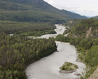
The Klutina River is a 63-mile (101 km) tributary of the Copper River in the U.S. state of Alaska. Beginning at Klutina Glacier in the Chugach Mountains, the river flows generally northeast, passing through Klutina Lake, to meet the larger river at the community of Copper Center. The river mouth is 66 miles (106 km) northeast of Valdez.
Mentasta Pass is a major mountain pass in Alaska, separating the Alaska Range on the west from the Mentasta Mountains on the east. Alaska Route 1 runs through the pass, connecting the Copper River Valley with the Alaska Highway.

The Tubutulik River is a waterway in the U.S. state of Alaska. The 25-mile (40 km) long river is situated on the Seward Peninsula. It flows southeastwards to the Kwiniuk Inlet at the northwestern end of Norton Bay, 25 miles (40 km) southwest of Koyuk in the Bering Sea. Its Inuit name was reported as "Tubuktulik" in 1849 by Capt. Mikhail Dmitrievich Tebenkov of the Imperial Russian Navy. Exploration for placer gold occurred in the Council district area where the river valley is located, and in 1898, mining commenced. The production was substantial and ranked second only to that of Nome.
John Bremner (1833–1887) was a prospector and early explorer of Alaska.

The White River is a tributary about 200 miles (320 km) long, of the Yukon River in the U.S. state of Alaska and the Canadian territory of Yukon. The Alaska Highway crosses the White River near Beaver Creek.
The Kruzgamepa River is a 55-mile (89 km) tributary of the Kuzitrin River on the Seward Peninsula in the U.S. state of Alaska. The river begins at Salmon Lake, elevation 447 feet (136 m), and descends to 20 feet (6.1 m) above sea level at its mouth. In turn, the Kuzitrin River empties into the Imuruk Basin. The basin drains via the bay of Port Clarence to the Bering Sea.
Nome River is a waterway on the Seward Peninsula in the U.S. state of Alaska. It has its source in a narrow valley in the southern margin of the Kigluaik Mountains, 4.5 miles (7.2 km) west of Salmon Lake.

Copper River Census Area is a census area located in the state of Alaska, United States. It is part of the Unorganized Borough and therefore has no borough seat. On January 2, 2019, it was split from the Valdez–Cordova Census Area, along with neighboring Chugach Census Area.

