
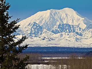
Denali is the highest mountain peak in North America, with a summit elevation of 20,310 feet (6,190 m) above sea level. With a topographic prominence of 20,194 feet (6,155 m) and a topographic isolation of 4,621.1 miles (7,436.9 km), Denali is the third most prominent and third most isolated peak on Earth, after Mount Everest and Aconcagua. Located in the Alaska Range in the interior of the U.S. state of Alaska, Denali is the centerpiece of Denali National Park and Preserve.

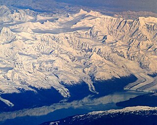
Mount Blackburn is the highest peak in the Wrangell Mountains of Alaska in the United States. It is the fifth-highest peak in the United States and the twelfth-highest peak in North America. The mountain is an old, eroded shield volcano, the second-highest volcano in the U.S. behind Mount Bona and the fifth-highest in North America. It was named in 1885 by Lt. Henry T. Allen of the U.S. Army after Joseph Clay Stiles Blackburn, a U.S. senator from Kentucky. It is located in the heart of Wrangell – St. Elias National Park, the largest national park in the country.

Mount Hunter or Begguya is a mountain in Denali National Park in Alaska. It is approximately eight miles (13 km) south of Denali, the highest peak in North America. "Begguya" means child in the Dena'ina language. Mount Hunter is the third-highest major peak in the Alaska Range.
University Peak is a high peak in the Saint Elias Mountains of Alaska. It is one of the twenty highest peaks in Alaska, and one of the fifty highest peaks in the United States. It can be considered a southern outlier of the large massif of Mount Bona. However, it is a much steeper peak than Bona, and presents significant climbing challenges of its own.

Mount Hayes is the highest mountain in the eastern Alaska Range, in the U.S. state of Alaska. Despite not being a fourteener, it is one of the largest peaks in the United States in terms of rise above local terrain. For example, the Northeast Face rises 8,000 feet (2,440 m) in approximately 2 miles (3.2 km). This large vertical relief contributes to Mount Hayes being the 51st most topographically prominent peak in the world.

Mount Crillon is a high peak of the Fairweather Range, the southernmost part of the Saint Elias Mountains. It lies southeast of Mount Fairweather, in the promontory between the Gulf of Alaska and Glacier Bay. It is included in Glacier Bay National Park. The peak was named after Felix-Francois-Dorothee de Bretton, Comte de Crillon, by his friend, the French explorer Jean Francois de Galaup de la Perouse.

Mount Deborah is a mountain in the U.S. state of Alaska. It is one of the major peaks of the eastern Alaska Range. Despite its low absolute elevation, it is a particularly large and steep peak in terms of its quick rise over local terrain. For example, the Northeast Face rises 7000 feet (2135m) in approximately 1.5 miles (2.4 km). This steepness, combined with difficult access, harsh weather, and classic Alaskan ice and snow features, make this a challenging peak to climb.

Mount Bona is one of the major mountains of the Saint Elias Mountains in eastern Alaska, and is the fifth-highest independent peak in the United States. Mount Bona and its adjacent neighbor Mount Churchill are both large ice-covered stratovolcanoes. Bona has the distinction of being the highest volcano in the United States and the fourth-highest in North America, outranked only by the three highest Mexican volcanoes, Pico de Orizaba, Popocatépetl, and Iztaccíhuatl. Its summit is a small stratovolcano on top of a high platform of sedimentary rocks.
Mount Marcus Baker is the highest peak of the Chugach Mountains of Alaska. It is located approximately 75 miles (121 km) east of Anchorage. This peak is very prominent because of its proximity to tidewater and is only 12 miles (19 km) north of the calving face of Harvard Glacier. When ranked by topographic prominence, Mount Marcus Baker is one of the top 75 peaks in the world.

Mount Dickey is a peak on the west side of the Ruth Gorge in the Central Alaska Range of mountains, 12 miles (19 km) southeast of Denali and 4 miles (6 km) southwest of The Moose's Tooth. Despite its relatively low elevation, it is notable for its east face, which has around a vertical mile of sheer granite—it achieves this vertical gain in less than half a mile (800m) horizontal distance. This is one of the tallest rock walls in the world, and the face has seen many world-class climbs.

Mount Neacola is the unofficial name for the high point of the Neacola Mountains, the northernmost section of the Aleutian Range of Alaska. Despite its low elevation compared to many of the major Alaskan peaks, Mount Neacola is an impressive peak, due to its steep, pointed shape and its low base.
Mount Miller is an isolated peak of the Saint Elias Mountains in Alaska, United States. It is notable for its position among spectacular icefields, its distance from any inhabited place, and its large rise above local terrain. It is over 65 miles (110 km) from McCarthy, the nearest habitation, and over 105 miles (170 km) away from Yakutat, the nearest significant town. Exemplifying the size of the mountain, the south flank rises 9000 feet above the Duktoth River valley to the south in approximately 9 horizontal miles (14.5 km).
Mount Steller is a peak at the far eastern end of the Chugach Mountains of Alaska, United States. It is notable for its isolated location among extensive icefields, and for its large rise above local terrain. For example, it rises 8000 feet above the Bering Glacier to the south in about 4 horizontal miles (6.4 km).

Mount Moffit is a peak in the Alaska Range in central Alaska, United States, about 10 miles (16 km) east-southeast of Mount Hayes. It is notable for its steep faces and large relief above local terrain. For example, the north face drops 7,400 feet in approximately 1.2 miles (2 km) horizontal distance.
Mount Natazhat is a high peak of the Saint Elias Mountains, of Alaska, United States, just west of the border with the Yukon Territory of Canada. It lies on the northern edge of the range, south of the White River and north of the Klutlan Glacier. Mount Natazhat is a little-noticed peak; however it is a very large peak in terms of rise above local terrain. It rises 9,000 feet (2,743 m) in less than 7 miles (11.3 km) above the lowlands to the north, and 7,500 feet (2,286 m) in about 4 miles (6.4 km) above the Klutlan Glacier to the south.
Mount Russell is one of the major peaks of the central Alaska Range, approximately 35 mi (56 km) southwest of Denali. Though much lower than Denali or its neighbor Mount Foraker, Russell is a steep, dramatic peak and a significant mountaineering challenge in its own right. To give a sense of its size and steepness, note that its summit rises 6,560 ft over the Chedotlothna Glacier to the northwest in only 1.8 mi (3 km), and almost 10,000 ft above the lower Yentna Glacier to the south in only 8 mi (13 km).

Mount Drum is a stratovolcano in the Wrangell Mountains of east-central Alaska in the United States. It is located at the extreme western end of the Wrangells, 18 miles (29 km) west-southwest of Mount Sanford and the same distance west-northwest of Mount Wrangell. It lies just inside the western boundary of Wrangell-Saint Elias National Park and Preserve and is 25 miles (40 km) east of the Copper River.
Mount Igikpak is the highest peak in the Schwatka Mountains region of the Brooks Range. It is also the tallest mountain in Gates of the Arctic National Park, located in the US state of Alaska. Some sources list the height of its summit at 8,510'. Mount Igikpak is in the south central part of the national park, very close to the source of the Noatak River and not far from the Arrigetch Peaks.

Bashful Peak is a mountain in the U.S. state of Alaska, located in Chugach State Park. At 8,005 feet (2,440 m), Bashful is the highest peak in Chugach State Park, and the highest peak in the Municipality of Anchorage. The peak carries snow year-round and several small glaciers hang from its steep western face.

Mount Seattle is a 10,350-foot (3,150 m) peak in the Saint Elias Mountains of Alaska in the United States. It was named for the city of Seattle, home of the "camp hands" of a 19th-century National Geographic Society–United States Geological Survey scientific expedition to the Hubbard Glacier and Mount Saint Elias. It is called the "most prominent Alaskan coastal peak" and blocks sight of larger inland peaks, even Mount Logan nearly twice its height.

