Slapy | |
|---|---|
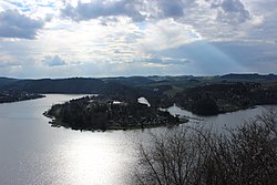 Slapy Reservoir and Slapy village | |
 Flag  Coat of arms | |
 Slapy Location in the Czech Republic | |
| Coordinates: 49°48′55″N14°23′46″E / 49.81528°N 14.39611°E | |
| Country | |
| Region | Central Bohemian |
| District | Prague-West |
| First mentioned | 1292 |
| Area | |
• Total | 20.24 km2 (7.81 sq mi) |
| Elevation | 358 m (1,175 ft) |
| Population (2025-01-01) [1] | |
• Total | 965 |
| • Density | 48/km2 (120/sq mi) |
| Time zone | UTC+1 (CET) |
| • Summer (DST) | UTC+2 (CEST) |
| Postal code | 252 08 |
| Website | www |
Slapy is a municipality and village in Prague-West District in the Central Bohemian Region of the Czech Republic. It has about 1,000 inhabitants. It is located on the shore of Slapy Reservoir.