Related Research Articles

The Gulf Coast of the United States, also known as the Gulf South, is the coastline along the Southern United States where they meet the Gulf of Mexico. The coastal states that have a shoreline on the Gulf of Mexico are Texas, Louisiana, Mississippi, Alabama, and Florida, and these are known as the Gulf States.

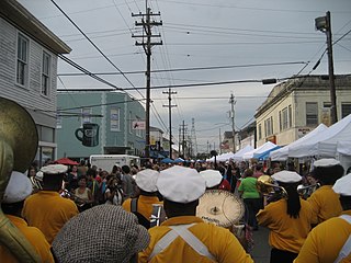
New Orleans is a consolidated city-parish located along the Mississippi River in the southeastern region of the U.S. state of Louisiana. With a population of 383,997 according to the 2020 U.S. census, it is the most populous city in Louisiana and the twelfth-most populous city in the southeastern United States. Serving as a major port, New Orleans is considered an economic and commercial hub for the broader Gulf Coast region of the United States.

The French Quarter, also known as the Vieux Carré, is the oldest neighborhood in the city of New Orleans. After New Orleans was founded in 1718 by Jean-Baptiste Le Moyne de Bienville, the city developed around the Vieux Carré, a central square. The district is more commonly called the French Quarter today, or simply "The Quarter", related to changes in the city with American immigration after the 1803 Louisiana Purchase. Most of the extant historic buildings were constructed either in the late 18th century, during the city's period of Spanish rule, or were built during the first half of the 19th century, after U.S. purchase and statehood.

The Faubourg Marigny is a neighborhood of the city of New Orleans, Louisiana, United States.

Bywater is a neighborhood of the city of New Orleans. A subdistrict of the Bywater District Area, its boundaries as defined by the City Planning Commission are: Florida Avenue to the north, the Industrial Canal to the east, the Mississippi River to the south, and the railroad tracks along Homer Plessy Way to the west. Bywater is part of the Ninth Ward of New Orleans. It includes part or all of Bywater Historic District, which is listed on the National Register of Historic Places.

The Ninth Ward or 9th Ward is a distinctive region of New Orleans, Louisiana, which is located in the easternmost downriver portion of the city. It is geographically the largest of the 17 Wards of New Orleans. On the south, the Ninth Ward is bounded by the Mississippi River. On the western or "upriver" side, the Ninth Ward is bounded by Franklin Avenue, then Almonaster Avenue, then People's Avenue. From the north end of People's Avenue the boundary continues on a straight line north to Lake Pontchartrain; this line is the boundary between the Ninth and the city's Eighth Ward. The Lake forms the north and northeastern end of the ward. St. Bernard Parish is the boundary to the southeast, Lake Borgne farther southeast and east, and the end of Orleans Parish to the east at the Rigolets.

Hurricane Katrina was a destructive Category 5 Atlantic hurricane that caused 1,392 fatalities and between $97.4 billion to $145.5 billion in damage in late August 2005, especially in the city of New Orleans and the surrounding areas. It was at the time the costliest tropical cyclone on record and is now tied with 2017's Hurricane Harvey. The storm was the twelfth tropical cyclone, the fifth hurricane, and the third major hurricane of the 2005 Atlantic hurricane season, as well as the fourth-most intense Atlantic hurricane on record to make landfall in the contiguous United States.

As the center of Hurricane Katrina passed southeast of New Orleans on August 29, 2005, winds downtown were in the Category 1 range with frequent intense gusts. The storm surge caused approximately 23 breaches in the drainage canal and navigational canal levees and flood walls. As mandated in the Flood Control Act of 1965, responsibility for the design and construction of the city's levees belongs to the United States Army Corps of Engineers and responsibility for their maintenance belongs to the Orleans Levee Board. The failures of levees and flood walls during Katrina are considered by experts to be the worst engineering disaster in the history of the United States. By August 31, 2005, 80% of New Orleans was flooded, with some parts under 15 feet (4.6 m) of water. The famous French Quarter and Garden District escaped flooding because those areas are above sea level. The major breaches included the 17th Street Canal levee, the Industrial Canal levee, and the London Avenue Canal flood wall. These breaches caused the majority of the flooding, according to a June 2007 report by the American Society of Civil Engineers. The flood disaster halted oil production and refining which increased oil prices worldwide.
The article covers the Hurricane Katrina effects by region, within the United States and Canada. The effects of Hurricane Katrina, in late August 2005, were catastrophic and widespread. It was one of the deadliest natural disasters in U.S. history, leaving at least 1,836 people dead, and a further 135 missing. The storm was large and had an effect on several different areas of North America.

Hurricane preparedness in New Orleans has been an issue since the city's early settlement because of its location.
Hurricane Katrina had many social effects, due the significant loss and disruption of lives it caused. The number of fatalities, direct and indirect, related to Katrina is 1,833 and over 400,000 people were left homeless. The hurricane left hundreds of thousands of people without access to their homes or jobs, it separated people from relatives, and caused both physical and mental distress on those who suffered through the storm and its aftermath, such as Post-traumatic stress disorder (PTSD).
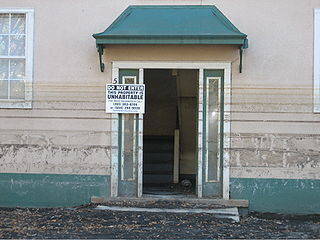
The reconstruction of New Orleans refers to the rebuilding process endured by the city of New Orleans after Hurricane Katrina destroyed much of the city on August 29, 2005. The storm caused levees to fail, releasing tens of billions of gallons of water. The levee failure contributed to extensive flooding in the New Orleans area and surrounding parishes. About 80% of all structures in Orleans Parish sustained water damage. Over 204,000 homes were damaged or destroyed, and more than 800,000 citizens displaced—the greatest displacement in the United States since the Dust Bowl of the 1930s. Wind damage was less severe than predicted. The damage that took place that needed to be repaired cost about $125 billion.

The Lower Ninth Ward is a neighborhood in the city of New Orleans, Louisiana. As the name implies, it is part of the 9th Ward of New Orleans. The Lower Ninth Ward is often thought of as the entire area within New Orleans downriver of the Industrial Canal; however, the City Planning Commission divides this area into the Lower Ninth Ward and Holy Cross neighborhoods.
On Monday, August 29, 2005, there were over 50 failures of the levees and flood walls protecting New Orleans, Louisiana, and its suburbs following passage of Hurricane Katrina. The failures caused flooding in 80% of New Orleans and all of St. Bernard Parish. In New Orleans alone, 134,000 housing units — 70% of all occupied units — suffered damage from Hurricane Katrina and the subsequent flooding.
Drainage in New Orleans, Louisiana, has been a major concern since the founding of the city in the early 18th century, remaining an important factor in the history of New Orleans today. The central portion of metropolitan New Orleans is fairly unusual in that it is almost completely surrounded by water: Lake Pontchartrain to the north, Lake Borgne to the east, wetlands to the east and west, and the Mississippi River to the south. Half of the land area between these bodies of water is at or below sea level, and no longer has a natural outlet for flowing surface water. As such, virtually all rainfall occurring within this area must be removed through either evapotranspiration or pumping. Thus, flood threats to metropolitan New Orleans include the Mississippi River, Lake Pontchartrain, canals throughout the city, and natural rainfall. Artificial levees have been built to keep out rising river and lake waters but have had the negative effect of keeping rainfall in, and have failed on numerous occasions.

Broadmoor is a neighborhood of the city of New Orleans. A subdistrict of the Uptown/Carrollton Area, its boundaries as defined by the New Orleans City Planning Commission are: Eve Street to the north, Washington Avenue and Toledano Street to the east, South Claiborne Avenue to the south, and Jefferson Avenue, South Rocheblave Street, Nashville Avenue, and Octavia Street to the west. It includes the Broadmoor Historic District which was listed on the National Register of Historic Places in 2003 and increased in its boundaries in 2007.

Uptown is a section of New Orleans, Louisiana, United States, on the east bank of the Mississippi River, encompassing a number of neighborhoods between the French Quarter and the Jefferson Parish line. It remains an area of mixed residential and small commercial properties, with a wealth of 19th-century architecture. It includes part or all of Uptown New Orleans Historic District, which is listed on the National Register of Historic Places.

Gert Town is a neighborhood in the city of New Orleans, Louisiana. It is the home to Xavier University of Louisiana and is a part of the Mid-City District. Gert Town played a major role in the industrial development of the New Orleans region. The Blue Plate Mayonnaise Factory, Coca-Cola Bottling Plant, Sealtest Dairy, and Thompson-Hayward Chemical Company were all fundamental manufacturing bases of the working-class neighborhood. Gert Town was also well known for being a center of development for jazz and other music genres. Musicians such as Buddy Bolden, John Robichaux, Merry Clayton, Bunk Johnson and Allen Toussaint all came from the neighborhood and helped shape the musical influence of New Orleans.
Leonidas is a neighborhood designation in the city of New Orleans. A subdistrict of the Uptown/Carrollton Area, its boundaries as defined by the New Orleans City Planning Commission are: South Claiborne Avenue, Leonidas and Fig Streets to the north, South Carrollton Avenue to the east, the Mississippi River and Jefferson Parish to the west. Although an official city planning district name, the name "Leonidas" is not widely used nor has it any historical usage and the area is usually referred to by the larger neighborhood "Uptown, or "Carrollton".
References
- ↑ https://www.latimes.com/archives/la-xpm-2006-feb-26-na-orleans26-story.html
- ↑ https://www.loe.org/shows/segments.html?programID=15-P13-00035&segmentID=2
- ↑ https://www.npr.org/2007/05/21/10292676/new-orleans-tours-include-hurricane-ruin
- ↑ Here you'll find the historic houses, most of the nightclubs and restaurants, supermarkets and home supply centers.
- ↑ "Very few takers for loans to rebuild New Orleans". The New York Times. 2006-03-06. ISSN 0362-4331 . Retrieved 2023-01-31.
| | This New Orleans, Louisiana–related article is a stub. You can help Wikipedia by expanding it. |