
Quesnel is a city located in the Cariboo Regional District of British Columbia, Canada. Located nearly evenly between the cities of Prince George and Williams Lake, it is on the main route to northern British Columbia and the Yukon. Quesnel is located at the confluence of the Fraser River and Quesnel River. Quesnel's metropolitan area has a population of 23,146 making it one of the largest urban centers between Prince George and Kamloops.

Cranbrook is a city in southeast British Columbia, Canada, located on the west side of the Kootenay River at its confluence with the St. Mary's River. It is the largest urban centre in the region known as the East Kootenay. As of 2016, Cranbrook's population is 20,499 with a census agglomeration population of 27,040. It is the location of the headquarters of the Regional District of East Kootenay and also the location of the regional headquarters of various provincial ministries and agencies, notably the Rocky Mountain Forest District.

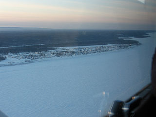
Fort St. John is a city located in northeastern British Columbia, Canada. The most populous municipality in the Peace River Regional District, the city encompasses a total area of about 22 km2 (8.5 sq mi) with 21,465 residents recorded in the 2021 Census. Located at Mile 47 of the Alaska Highway, it is one of the largest cities between Dawson Creek, British Columbia and Delta Junction, Alaska. Established in 1794 as a trading post, Fort St. John is the oldest European-established settlement in present-day British Columbia. The city is served by the Fort St. John Airport. The municipal slogan is Fort St. John: The Energetic City.

Lytton is a village of about 250 residents in southern British Columbia, Canada, on the east side of the Fraser River and primarily the south side of the Thompson River, where it flows southwesterly into the Fraser. The community includes the Village of Lytton and the surrounding community of the Lytton First Nation, whose name for the place is Camchin, also spelled Kumsheen.

Castlegar is a community in the West Kootenay region of British Columbia, Canada. In the Selkirk Mountains, at the confluence of the Kootenay and Columbia Rivers, it is a regional trade and transportation centre, with a local economy based on forestry, mining and tourism.
Fort Simpson is a village, the only one in the entire territory, in the Dehcho Region of the Northwest Territories, Canada. The community is located on an island at the confluence of the Mackenzie and Liard rivers. It is approximately 500 km (310 mi) west of Yellowknife. Both rivers were traditionally trade routes for the Hudson's Bay Company and the native Dene people of the area.

Williams Lake is a city in the Central Interior of British Columbia, in the central part of a region known as the Cariboo. Williams Lake is one of the largest cites, by population of metropolitan area, in the Cariboo after neighbouring Quesnel. The city is famous for the Williams Lake Stampede, which was once the second largest professional rodeo in Canada, after only the Calgary Stampede.
Fort Nelson is a community in northeast British Columbia, Canada, within the Northern Rockies Regional Municipality (NRRM). It held town status prior to 6 February 2009, when it amalgamated with the former Northern Rockies Regional District to form the NRRM, becoming its administrative centre. The NRRM is the first regional municipality in the province.

Watson Lake is a town in Yukon, Canada, located at mile 635 on the Alaska Highway close to the British Columbia border. It has a population of 790 in 2016. The town is named for Frank Watson, an American-born trapper and prospector, who settled in the area at the end of the 19th century.

Kugluktuk, formerly known as Coppermine until 1 January 1996, is a hamlet located at the mouth of the Coppermine River in the Kitikmeot Region of Nunavut, Canada, on Coronation Gulf, southwest of Victoria Island. It is the westernmost community in Nunavut, near the border with the Northwest Territories.

Snag is a village located on a small, dry-weather sideroad off the Alaska Highway, 25 kilometres (16 mi) east of Beaver Creek, Yukon, Canada. The village of Snag is located in a bowl-shaped valley of the White River and its tributaries, including Snag Creek. It was first settled during the Klondike Gold Rush. An aboriginal village was also located approximately 8 kilometres (5 mi) away. It was the site of a military airfield, established as part of the Northwest Staging Route, which closed in 1968. In 1947, the village of Snag boasted a population of eight to ten First Nation people and fur traders. An additional staff of fifteen to twenty airport personnel — meteorologists, radio operators, aircraft maintenance men — lived at the airport barracks.

Bella Coola is a unincorporated community in the Bella Coola Valley of British Columbia, Canada. Bella Coola usually refers to the entire valley, encompassing the settlements of Bella Coola proper, Lower Bella Coola, Hagensborg, Salloompt, Nusatsum, Firvale, and Stuie. It is also the location of the head offices of the Central Coast Regional District.

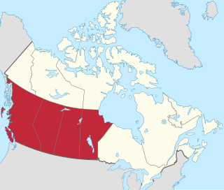
British Columbia is the westernmost province of Canada, bordered by the Pacific Ocean. With an area of 944,735 km2 (364,764 sq mi) it is Canada's third-largest province. The province is almost four times the size of the United Kingdom and larger than every United States state except Alaska. It is bounded on the northwest by the U.S. state of Alaska, directly north by Yukon and the Northwest Territories, on the east by Alberta, and on the south by the U.S. states of Washington, Idaho, and Montana. Formerly part of the British Empire, the southern border of British Columbia was established by the 1846 Oregon Treaty. The province is dominated by mountain ranges, among them the Canadian Rockies but dominantly the Coast Mountains, Cassiar Mountains, and the Columbia Mountains. Most of the population is concentrated on the Pacific coast, notably in the area of Vancouver, located on the southwestern tip of the mainland, which is known as the Lower Mainland. It is the most mountainous province of Canada.
Fort Liard is a hamlet in the Dehcho Region of the Northwest Territories, Canada. It is located 37 km (23 mi) north of the British Columbia border. It became accessible by road in 1984 with the completion of the Liard Highway.
Liard River Hot Springs Provincial Park is a provincial park in British Columbia, Canada. It is home to the second largest natural hot springs in Canada, after Deer River Hot Springs 15 km to the north east. It is a natural river of hot water rather than a spring fed man made pool. The park is part of the larger Muskwa-Kechika Management Area. The community of Liard River, British Columbia is located nearby.

Masset is a village in the Haida Gwaii archipelago in British Columbia, Canada. It is located on Masset Sound on the northern coast of Graham Island, the largest island in the archipelago, and is approximately 50 km (31 mi) west of mainland British Columbia. It is the primary western terminus of Trans-Canada Highway 16 and is served by Masset Airport, with flights to Vancouver and Prince Rupert. During the maritime fur trade of the early 19th century, Masset was a key trading site. It was incorporated as a village municipality on May 11, 1961.
The city of Vancouver, located in British Columbia, Canada, has a moderate oceanic climate that borders on a warm-summer Mediterranean climate (Csb). Its summer months are typically dry, often resulting in moderate drought conditions, usually in July and August. In contrast, the rest of the year is rainy, especially between October and March.
Western Canada, also referred to as the Western provinces, Canadian West or the Western provinces of Canada, and commonly known within Canada as the West, is a Canadian region that includes the four western provinces just north of the Canada–United States border namely British Columbia, Alberta, Saskatchewan and Manitoba. The people of the region are often referred to as "Western Canadians" or "Westerners", and though diverse from province to province are largely seen as being collectively distinct from other Canadians along cultural, linguistic, socioeconomic, geographic and political lines. They account for approximately 32% of Canada's total population.
The Smith River is a river in the Yukon Territory and the province of British Columbia, Canada, arising in the Yukon at 60°09′N126°18′W and crossing the border to enter British Columbia at 60°00′00″N126°23′25″W to its confluence with the Liard River at 59°33′00″N126°29′00″W, between the confluences of the Toad and Coal Rivers. At the confluence is the site of the former Hudson's Bay Company trading post, Fort Halkett, and also Smith River Falls, which are jointly protected by Smith River Falls-Fort Halkett Provincial Park.

Tofino is a town of approximately 2,516 residents on the west coast of Vancouver Island in the Canadian province of British Columbia. The District of Tofino is located at the western terminus of Highway 4 on the tip of the Esowista Peninsula at the southern edge of Clayoquot Sound. It is situated in the traditional territory of the Tla-o-qui-aht First Nations.
