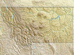
Montana is a landlocked state in the Northwestern United States. Montana has several nicknames, although none are official, including "Big Sky Country" and "The Treasure State", and slogans that include "Land of the Shining Mountains" and more recently "The Last Best Place".

The Absaroka Range is a sub-range of the Rocky Mountains in the United States. The range stretches about 150 mi (240 km) across the Montana-Wyoming border, and 75 miles at its widest, forming the eastern boundary of Yellowstone National Park along Paradise Valley (Montana), and the western side of the Bighorn Basin. The range borders the Beartooth Mountains to the north and the Wind River Range to the south. The northern edge of the range rests along I-90 and Livingston, Montana. The highest peak in the range is Francs Peak, located in Wyoming at 13,153 ft (4,009 m). There are 46 other peaks over 12,000 ft (3,700 m).

Great Smoky Mountains National Park is an American national park and a UNESCO World Heritage Site that straddles the ridgeline of the Great Smoky Mountains, part of the Blue Ridge Mountains, which are a division of the larger Appalachian Mountain chain. The border between Tennessee and North Carolina runs northeast to southwest through the centerline of the park. Great Smoky Mountains is the most visited national park in the United States with over 11.3 million recreational visitors in 2016. The Appalachian Trail passes through the center of the park on its route from Maine to Georgia. The park was chartered by the United States Congress in 1934 and officially dedicated by President Franklin D. Roosevelt in 1940.
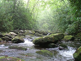
The Great Smoky Mountains are a mountain range rising along the Tennessee–North Carolina border in the southeastern United States. They are a subrange of the Appalachian Mountains, and form part of the Blue Ridge Physiographic Province. The range is sometimes called the Smoky Mountains and the name is commonly shortened to the Smokies. The Great Smokies are best known as the home of the Great Smoky Mountains National Park, which protects most of the range. The park was established in 1934, and, with over 11 million visits per year, it is the most visited national park in the United States.
The Cherokee National Forest is a large National Forest created on June 14, 1920 and managed by the U.S. Forest Service and encompassing some 655,598 acres (2,653.11 km2).
The Unaka Range is a mountain range on the border of Tennessee and North Carolina, in the southeastern United States. It is a subrange of the Appalachian Mountains and is part of the Blue Ridge Mountains physiographic province. The Unakas stretch approximately from the Nolichucky River to the south to the Watauga River to the north. The Unakas include the prominent Roan Highlands, where several summits rise above 6,000 feet. The Iron Mountains border the Unakas to the north, and the Bald Mountains border the Unakas opposite the Nolichucky to the south. The name unaka is rooted in the Cherokee term unega, meaning "white".
Smoky or Smokey may refer to:

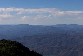
Mount Guyot is a mountain in the eastern Great Smoky Mountains, located in
the southeastern United States. At 6,621 feet (2,018 m) above sea level, Guyot is the fourth-highest
summit in the eastern U.S., and the second-highest in the Great Smoky Mountains National Park. While the mountain is remote, the Appalachian Trail crosses its south slope,
passing to within 1,000 feet (300 m) of the summit.

The Bald Mountains are a mountain range rising along the border between Tennessee and North Carolina in the southeastern United States. They are part of the Blue Ridge Mountain Province of the Southern Appalachian Mountains. The Bald Mountains stretch from the Pigeon River in the south to the Nolichucky River in the north, and comprise parts of Cocke County, Greene County, and Unicoi County in Tennessee and parts of Madison County and Yancey County in North Carolina. The Great Smoky Mountains border the range to the south, and the Unakas rise opposite the Nolichucky to the north. The range gets its name from the relatively frequent occurrence of grassy balds atop the more prominent summits.

The brown-collared dart is a moth of the family Noctuidae. It is found in eastern North America from New Brunswick to Alberta in southern Canada, and in the United States from Maine to North Carolina and Tennessee west to Mississippi, north to Minnesota, with scattered records in the west from North Dakota, South Dakota and Montana.

The Centennial Mountains are the southernmost sub-range of the Bitterroot Range in the United States states of Idaho and Montana. The Centennial Mountains include the Western and Eastern Centennial Mountains. The range extends east from Monida Pass along the Continental Divide to Henrys Fork 48 km (30 mi) NNW of Ashton, Idaho; bounded on the west by Beaver Creek, on the north by Centennial Valley and Henrys Lake Mountains, on the east by Henrys Lake Flat, and on the south by Shotgun Valley and the Snake River Plain. The highest peak in the range is Mount Jefferson.

The Mountain States form one of the nine geographic divisions of the United States that are officially recognized by the United States Census Bureau. It is a subregion of the Western United States.

The Soldier Mountains are a mountain range in the U.S. state of Idaho, spanning northern Camas and eastern Elmore counties. The highest point in the range is Smoky Dome at 10,095 feet (3,077 m), and the range is bounded on the west and north by the South Fork Boise River. The mountains are located within Sawtooth National Forest north of Fairfield, Idaho. The Soldier Mountain Ski Area is located within the range to the east of Smoky Dome.

The Smoky Mountains are part of the Rocky Mountains and located on the west side of the Wood River Valley near Sun Valley, Idaho, in the Western United States. The range is within Sawtooth National Forest, while part of it is within the Sawtooth National Recreation Area. The highest point in the range is Saviers Peak at 10,441 ft (3,182 m).

Smoky Mountain, at 7,579 feet (2,310 m) above sea level is a peak in the Albion Mountains of Idaho. The peak is located in Cassia County about 0.35 mi (0.56 km) east of the border of City of Rocks National Reserve on land managed by the Bureau of Land Management. It is 4.7 mi (7.6 km) north of the Nevada border.