
South Teton is the fifth-highest peak in the Teton Range, Grand Teton National Park, in the U.S. state of Wyoming. The peak is south of Middle Teton and just west of Cloudveil Dome and is part of the Cathedral Group of high Teton peaks. The 40-mile-long (64 km) Teton Range is the youngest mountain chain in the Rocky Mountains, and began their uplift 9 million years ago, during the Miocene. Several periods of glaciation have carved South Teton and the other peaks of the range into their current shapes.
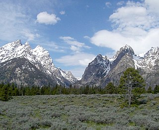
Cascade Canyon is located in Grand Teton National Park, in the U.S. state of Wyoming. The canyon was formed by glaciers which retreated at the end of the last glacial maximum approximately 15,000 years ago. Today, Cascade Canyon has numerous polished glacial erratics, hanging cirques and a U-shape as evidences that demonstrate that glaciers once filled the canyon to a depth of at least 2,000 feet (610 m). Rock debris that was transported out of the canyon by glacial motion formed moraines which now impound the waters of Jenny Lake which is located at the base of the canyon. Cascade Creek now flows where the glaciers once did and the numerous waterfalls, such as the 100-foot (30 m) tall Hidden Falls, found within the gorge are popular destinations with tourists.

Granite Canyon is located in Grand Teton National Park, in the U. S. state of Wyoming. The canyon was formed by glaciers which retreated at the end of the last glacial maximum approximately 15,000 years ago, leaving behind a U-shaped valley. The canyon lies between Rendezvous Mountain to the south and Mount Hunt to the north. The trailhead for the canyon is on the Moose–Wilson Road about 2 miles (3.2 km) north of Teton Village. One of the most popular hikes from the trailhead is to Marion Lake by way of the Granite Canyon Trail which traverses the length of the canyon. Another popular hike involves riding the aerial tram located at the Jackson Hole Mountain Resort in Teton Village to the top of Rendezvous Mountain, and then descending back to Teton Village by way of Granite Canyon. The descent from the summit of Rendezvous Peak back to Teton Village is an often steep one with an altitude loss of 4,100 feet (1,200 m). The historic Upper Granite Canyon Patrol Cabin is situated near the entrance to the canyon and was listed on the National Register of Historic Places in 1998.

Rolling Thunder Mountain is in the northern Teton Range, Grand Teton National Park, Wyoming. The peak is located northwest of Moran Bay on Jackson Lake and access to the peak involves navigating through several miles of backcountry areas of Snowshoe Canyon where there are no maintained trails.

Ranger Peak is in the northern Teton Range, Grand Teton National Park, Wyoming. The peak is located slightly northwest of and across Jackson Lake from Colter Bay Village. Colter Canyon is to the north while Waterfalls Canyon is immediately southeast of the peak, but there are no maintained trails in the area. Access to the summit involves off trail hiking and scrambling. The top of the mountain is more than 4,500 feet (1,400 m) above Jackson Lake.

Eagles Rest Peak is in the northern Teton Range, Grand Teton National Park, Wyoming. The peak is located west of and across Jackson Lake from Colter Bay Village. The peak rises dramatically almost 4,500 feet (1,400 m) above Jackson Lake in less than 1 mile (1.6 km). Waterfalls Canyon is to the north of the peak and Snowshoe Canyon lies to the south.

Bivouac Peak is in the northern Teton Range, Grand Teton National Park, Wyoming. The peak is located immediately to the west of Moran Bay on Jackson Lake, and rises more than 4,000 ft (1,200 m) in less than 0.5 mi (0.80 km) from the lakeshore. Moran Canyon is situated to the south of the mountain and Snowshoe Canyon lies to the north.
Traverse Peak is in the northern Teton Range, Grand Teton National Park, Wyoming. The mountain rises abruptly above Moran Canyon to the south and the south fork of Snowshoe Canyon to the north. From Moran Bay on Jackson Lake, the south slopes of the mountain can be seen behind Bivouac Peak rising above Moran Canyon.
Raynolds Peak is in the northern Teton Range, Grand Teton National Park, Wyoming. The mountain rises to the north of Moran Canyon and has numerous deep cirques on its north face above Snowshoe Canyon. There are no maintained trails in the region and the summit is 5 miles (8 km) west of Moran Bay on Jackson Lake. The peak is named after William F. Raynolds who was in charge of the 1859-1860 Raynolds Expedition to the region.

Rockchuck Peak is located in the Teton Range, Grand Teton National Park in the U.S. state of Wyoming. The mountain is immediately west of String Lake and south of Paintbrush Canyon. The summit is .5 miles (0.80 km) north of Mount Saint John.

Mount Saint John, height 11,435 feet (3,485 m), is located in the Teton Range, Grand Teton National Park, Wyoming, northwest of Jenny Lake. The mountain towers above the northwest shore of Jenny Lake, and along with Symmetry Spire and Rockchuck Peak, form a massif which looms to the north above Cascade Canyon. The scenic Lake of the Crags, a cirque lake or tarn, is located immediately south of the summit and is accessed by way of Hanging Canyon.
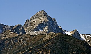
Buck Mountain 11,943 feet (3,640 m) is located in the Teton Range, Grand Teton National Park, Wyoming, immediately southeast of Grand Teton. The mountain is the highest summit south of Garnet Canyon and is easily seen from most vantage points in Jackson Hole. Views from the summit offer excellent views of the Cathedral Group to the north. The west slope of the summit tower are along the Alaska Basin Trail and extend into Caribou-Targhee National Forest and the Jedediah Smith Wilderness, which is the location of Alaska Basin, a popular wilderness camping area for backpackers. Timberline Lake is located on the eastern flanks of the peak.

Paintbrush Canyon is located in Grand Teton National Park, in the U. S. state of Wyoming. The canyon was formed by glaciers which retreated at the end of the last glacial maximum approximately 15,000 years ago. The canyon lies between Rockchuck Peak and Mount Saint John to the south and Mount Woodring to the north. Leigh Lake is at the base of the canyon to the east and the alpine Holly Lake is located mid canyon. Popular with hikers, the canyon is part of a popular circuit hike of 19.2 miles (30.9 km) which is rated as very strenuous and includes a total elevation change of 3,845 feet (1,172 m) due to the ascent to Paintbrush Divide 10,720 feet (3,270 m). Views from Paintbrush Divide include Lake Solitude and of Mount Moran to the north and the Cathedral Group including Grand Teton to the south. An ice axe may be necessary for hikes in the early summer. The Paintbrush Canyon Trail is part of the Teton Crest Trail, which spans the southern section of the Teton Range from Teton Pass along Wyoming Highway 22 to String Lake, a total distance of 39 miles (63 km).
The canyons of the Teton Range lie almost entirely within Grand Teton National Park in the U.S. state of Wyoming. Ranging from 9 miles (14 km) to less than 1 mile (1.6 km) in length and up to 6,000 feet (1,800 m) deep, the canyons were carved primarily by glaciers over the past 250,000 years. The canyons in the Teton Range descend in altitude generally west to east and many have lakes at their outlets. The lakes were created by terminal moraines left behind by the now retreated glaciers. A few of the canyons have small glaciers that were created mostly during the Little Ice Age (1550-1850). Fast retreating Schoolroom Glacier is a tiny glacier located at the head of the South Cascade Canyon. Most of the canyons have streams from which rain and snowmelt flow towards Jackson Hole valley, and due to the sometimes rapid altitude descent, waterfalls are common. The canyons offer the easiest hiking access into the Teton Range.

Webb Canyon is located in Grand Teton National Park, in the U. S. state of Wyoming. The canyon was formed by glaciers which retreated at the end of the last glacial maximum approximately 15,000 years ago, leaving behind a U-shaped valley. Webb Canyon is south of Owl Peak and the entrance to the canyon is near the northern reaches of Jackson Lake. Moose Creek flows through much of the 9 miles (14 km) long canyon and the Webb Canyon Trail traverses the length of the canyon to Moose Basin Divide.
Waterfalls Canyon is located in Grand Teton National Park, in the U. S. state of Wyoming. The canyon was formed by glaciers which retreated at the end of the last glacial maximum approximately 15,000 years ago, leaving behind a U-shaped valley. Waterfalls Canyon is south of Ranger Peak and north of Eagles Rest Peak and the entrance to the canyon is along the western shore of Jackson Lake, directly across the lake from the Colter Bay Village. There are several cascades in the canyon, including Wilderness Falls and Columbine Cascade, which descend from an unnamed lake below Ranger Peak.

Leigh Canyon is located in Grand Teton National Park, in the U. S. state of Wyoming. The canyon was formed by glaciers which retreated at the end of the last glacial maximum approximately 15,000 years ago, leaving behind a U-shaped valley. Leigh Canyon is approximately 6 miles (9.7 km) long and is flanked by Mount Moran and Thor Peak to the north and Mount Woodring to the south. The canyon outlet is at Leigh Lake and at the head of the canyon lies Mink Lake.

Avalanche Canyon is located in Grand Teton National Park, in the U. S. state of Wyoming. The canyon was formed by glaciers which retreated at the end of the last glacial maximum approximately 15,000 years ago, leaving behind a U-shaped valley. To the north of Avalanche Canyon lies South Teton, Cloudveil Dome and Nez Perce Peak while to the southwest lie Mount Wister and Veiled Peak. Snowdrift Lake and Lake Taminah are situated at the head of the canyon.
