
Port Moresby, also referred to as Pom City or simply Moresby, is the capital and largest city of Papua New Guinea. It is one of the largest cities in the southwestern Pacific outside of Australia and New Zealand. It is located on the shores of the Gulf of Papua, on the south-western coast of the Papuan Peninsula of the island of New Guinea. The city emerged as a trade centre in the second half of the 19th century. During World War II, it was a prime objective for conquest by the Imperial Japanese forces during 1942–43 as a staging point and air base to cut off Australia from Southeast Asia and the Americas.
Lae is the capital of Morobe Province and is the second-largest city in Papua New Guinea. It is located near the delta of the Markham River and at the start of the Highlands Highway, which is the main land transport corridor between the Highlands Region and the coast. Lae is the largest cargo port of the country and is the industrial hub of Papua New Guinea. The city is known as the Garden City and home of the University of Technology.
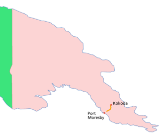
The Kokoda Track or Trail is a single-file foot thoroughfare that runs 96 kilometres (60 mi) overland – 60 kilometres (37 mi) in a straight line – through the Owen Stanley Range in Papua New Guinea (PNG). The track was the location of the 1942 World War II battle between Japanese and Allied – primarily Australian – forces in what was then the Australian territory of Papua.
Kokoda is a station town in the Oro Province of Papua New Guinea. It is famous as the northern end of the Kokoda Track, site of the eponymous Kokoda Track campaign of World War II. In that campaign, it had strategic significance because it had the only airfield along the Track. In the decades preceding, it had been a foothills settlement near the gold fields.
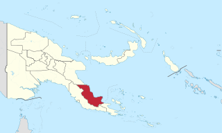
Oro Province, formerly Northern Province, is a coastal province in the Southern Region of Papua New Guinea. The provincial capital is Popondetta. The province covers 22,800 km2, and has 176,206 inhabitants. The province shares land borders with Morobe Province to the northwest, Central Province to the west and south, and Milne Bay Province to the southeast. The province is located within the Papuan Peninsula.
Tourism in Papua New Guinea is a fledgling industry but there are attractions for the potential visitor which include culture, markets, festivals, diving, surfing, hiking, fishing and the unique flora and fauna. Papua New Guinea receives an increasing number of visitors each year, with approximately 184,000 international arrivals in 2015.

Fuzzy Wuzzy Angels was the name given by Australian soldiers to Papua New Guinean war carriers who, during World War II, were recruited or forced into service to bring supplies up to the front and carry injured Australian troops down the Kokoda trail during the Kokoda Campaign. "Fuzzy-Wuzzy" was originally used by British soldiers in the 19th century as a name for Hadendoa warriors on the Red Sea coast of the Sudan, and referred to their elaborate butter-matted hairstyles.
Popondetta is the capital of Oro (Northern) Province in Papua New Guinea. Popondetta is a city.
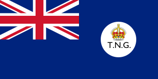
The Territory of New Guinea was an Australian-administered United Nations trust territory on the island of New Guinea from 1914 until 1975. In 1949, the Territory and the Territory of Papua were established in an administrative union by the name of the Territory of Papua and New Guinea. That administrative union was renamed as Papua New Guinea in 1971. Notwithstanding that it was part of an administrative union, the Territory of New Guinea at all times retained a distinct legal status and identity until the advent of the Independent State of Papua New Guinea.

Alotau is the capital of Milne Bay Province, in the south-east of Papua New Guinea. It is located on the northern shore of Milne Bay. The town is located within Alotau Urban LLG.
Boridi is a village in the Owen Stanley Range in Central Province, Papua New Guinea.
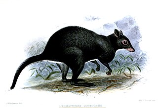
The gray dorcopsis or gray forest wallaby is a species of marsupial in the family Macropodidae. It is found in West Papua and Papua New Guinea.
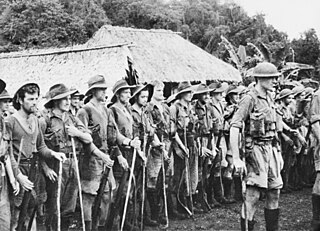
The 30th Brigade was a brigade-sized infantry unit of the Australian Army. Formed in December 1941, as part of the Militia, the unit was raised for service during the Second World War. Established in response to Japan's entry into the war, the brigade's subordinate units were established in several Australian states. Some of these had already been dispatched to New Guinea before the brigade's headquarters was established, although the majority arrived there in early 1942. Following their arrival, the brigade initially provided garrison troops to Port Moresby before later taking part in the fighting along the Kokoda Track during which elements took part in delaying actions around Kokoda and Isurava, before being relieved by units of the Second Australian Imperial Force. After the campaign began to turn in favour of the Australians, the Japanese withdrew north towards their beachheads around Buna and Gona, and elements of the brigade were recommitted to the fighting. In early 1943, the 30th Brigade was withdrawn back to Australia and was disbanded in July 1943, with its personnel being redistributed to other formations.
Kairuku-Hiri District is a district of Central Province in Papua New Guinea. It is one of the four administrative districts that make up the province, and surrounds the national capital, Port Moresby.
Bereina is a town in the Central Province of Papua New Guinea. It is located on the Hiritano Highway about 160 kilometres (100 mi) north-west of Port Moresby, and contains the headquarters of both the Kairuku-Hiri District and the Kairuku Rural local-level government area. Bereina also hosts a regional airport and a district town for the people of Kairuku Rural Area.
Boroko is a suburb of Port Moresby, the capital city of Papua New Guinea. It includes a residential area and a sports and recreation precinct, and was once a significant commercial centre but the business area is now in decline.

During the Second World War, Allied logistics in Papua played a crucial role in bringing the Kokoda Track campaign to a successful conclusion. "The great problem of warfare in the Pacific", General Douglas MacArthur declared, "is to move forces into contact and maintain them. Victory is dependent upon solution to the logistic problem."
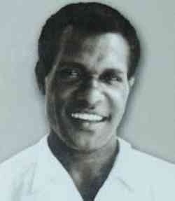
Sir Ebia Olewale (1940–2009) was a politician in Papua New Guinea (PNG). He was elected as a member of the House of Assembly of Papua and New Guinea in 1968 and went on to hold several ministerial positions during the period of self-governance and after PNG's independence in 1975, including that of deputy prime minister. He was knighted in 1983 and served as chancellor of the University of Goroka from 2000 to 2006. From 2002 until his death, he was a director of the Papua New Guinea Sustainable Development Program.
Sogeri National High School is a school situated in Sogeri in the Central Province of Papua New Guinea (PNG). It was the country's first national high school and it educates students from all over the country in Forms 5 and 6, prior to their going on to tertiary education. Many of PNG's leading politicians, administrators, business people and academics have been educated at the school. It was described by the country's first prime minister, Sir Michael Somare, himself a former pupil, as "the school that shaped the nation".
