Nordhausen is a Kreis (district) in the north of Thuringia, Germany. Neighboring districts are : Harz and Mansfeld-Südharz in Saxony-Anhalt; Kyffhäuserkreis and Eichsfeld in Thuringia; and Göttingen and Goslar in Lower Saxony.

Nordhausen is a city in Thuringia, Germany. It is the capital of the Nordhausen district and the urban centre of northern Thuringia and the southern Harz region; its population is 42,000. Nordhausen is located approximately 60 km north of Erfurt, 80 km west of Halle, 85 km south of Braunschweig and 60 km east of Göttingen.
Gernrode is a municipality in the district of Eichsfeld in Thuringia, Germany. Its agricultural land is some of the most productive in the district and it therefore does not have any wooded areas.

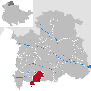
Bleicherode is a town in the district of Nordhausen, in Thuringia, Germany. It is situated on the river Wipper, 17 km southwest of Nordhausen. On 1 December 2007, the former municipality Obergebra was incorporated by Bleicherode. The former municipalities Etzelsrode, Friedrichsthal, Kleinbodungen, Kraja, Hainrode, Nohra, Wipperdorf and Wolkramshausen were merged into Bleicherode in January 2019. Every Tuesday and Thursday, there is a market held at the Zierbrunnenplatz in the town.

Ellrich is a town in the district of Nordhausen, in Thuringia, Germany. It is situated on the southern edge of the Harz, 13 km northwest of Nordhausen. It is the northernmost settlement in Thuringia.

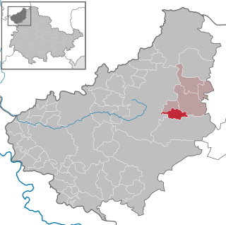
Heringen is a town in the district of Nordhausen, in Thuringia, Germany. It is situated on the small river Helme, 8 km southeast of Nordhausen.

Treffurt is a small town in the western region of the Wartburgkreis district which belongs to the federal state of Thuringia. The former municipality Ifta was merged into Treffurt in January 2019. The town lies near the Werra and is surrounded by the Werratal valley and rivers. Treffurt is located next to the Hessian border and was a former part of the Sperrzone. Today, Treffurt is a tourist destination, especially due to its scenic town centre with many restored half-timbered houses and its landmark - the Normannstein castle.

Hohenstein is a municipality in the district of Nordhausen, in Thuringia, Germany.

Nohra is a village and a former municipality in the district of Nordhausen, in Thuringia, Germany. As of 2018, Nohra had a population of 799.
Urbach is a municipality in the district of Nordhausen, in Thuringia, Germany.
Werther is a municipality in the district of Nordhausen, in Thuringia, Germany.
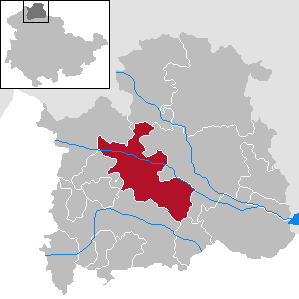
Großlohra is a municipality in the district of Nordhausen, in Thuringia, Germany, situated on the northern edge of the Hainleite ridge about 20 km (12 mi) southwest of the district capital. It consists of the settlements of Friedrichslohra, Großwenden, Kleinwenden, as well as Münchenlohra with its former convent basilica St. Gangulphus and castle Lohra with its accompanying manor, all of which were united in 1950.

Görsbach is a municipality in the district of Nordhausen, in Thuringia, Germany.

Kehmstedt is a municipality in the district of Nordhausen, in Thuringia, Germany.

Kleinfurra is a municipality in the district of Nordhausen, in Thuringia, Germany.

Lipprechterode is a municipality in the district of Nordhausen, in Thuringia, Germany.

Niedergebra is a municipality in the district of Nordhausen, in Thuringia, Germany.

Harztor is a municipality in the district of Nordhausen, in Thuringia, Germany. It was formed on 1 January 2012 by the merger of the former municipalities Ilfeld and Niedersachswerfen. In July 2018 the former municipalities of Harzungen, Herrmannsacker and Neustadt/Harz were merged into Harztor.
Nordhausen I is an electoral constituency represented in the Landtag of Thuringia. It elects one member via first-past-the-post voting. Under the current constituency numbering system, it is designated as constituency 3. It comprises the entirety of the district of Nordhausen with the exception of the city of Nordhausen, which compromises the constituency of Nordhausen II.
Nordhausen II is an electoral constituency represented in the Landtag of Thuringia. It elects one member via first-past-the-post voting. Under the current constituency numbering system, it is designated as constituency 4. It comprises the city of Nordhausen within the Nordhausen district.


