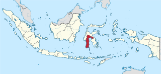
South Sulawesi is a province in the southern peninsula of Sulawesi, Indonesia. The Selayar Islands archipelago to the south of Sulawesi is also part of the province. The capital and largest city is Makassar. The province is bordered by Central Sulawesi and West Sulawesi to the north, the Gulf of Bone and Southeast Sulawesi to the east, Makassar Strait to the west, and Flores Sea to the south.
Makassar, formerly Ujung Pandang, is the capital of the Indonesian province of South Sulawesi. It is the largest city in the region of Eastern Indonesia and the country's fifth-largest urban center after Jakarta, Surabaya, Medan, and Bandung. The city is located on the southwest coast of the island of Sulawesi, facing the Makassar Strait.

East Kalimantan is a province of Indonesia. Its territory comprises the eastern portion of Borneo. It had a population of about 3.03 million at the 2010 census, 3.42 million at the 2015 census, and 3.766 million at the 2020 census; the official estimate as at mid 2023 was 4,030,488. Its capital is the city of Samarinda.

West Nusa Tenggara is a province of Indonesia. It comprises the western portion of the Lesser Sunda Islands, with the exception of Bali which is its own province. The province's land area is 19,931.45 km2. The two largest islands by far in the province are the smaller but much more populated Lombok in the west and the much larger in area but much less densely populated Sumbawa island in the east. Mataram, on Lombok, is the capital and largest city of the province. It shares maritime borders with Bali to the west and East Nusa Tenggara to the east.

Great Aceh Regency is a regency of the Indonesian province of Aceh. The regency covers an area of 2,903.49 square kilometres and had a population of 351,418 at the 2010 Census, 391,870 at the 2015 census and 405,535 at the 2020 Census; the official estimate as at mid 2023 was 435,298. The Regency is located at the northwest tip of Sumatra island and surrounds the provincial capital of Banda Aceh, many suburbs of which lie within the Regency. It also includes a number of islands off the northern tip of Sumatra, which comprise Pulo Aceh District within the regency. The seat of the Regency government is the town of Jantho.

Soppeng Regency is a landlocked regency in South Sulawesi province of Indonesia. Soppeng Regency has its seat of government (capital) in the town of Watansoppeng, located 180 km from Makassar. The regency covers an area of 1,385.55 km2, and had a population of 223,826 at the 2010 Census and 235,167 at the 2020 Census. The official estimate of population as of mid-2023 was 240,955.

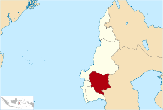
Gowa is a regency in the province of South Sulawesi, Indonesia. It has an area of 1,883.33 km2 and a population of 652,329 at the 2010 census, increasing to 765,836 at the 2020 census; the official estimate as at mid 2023 was 799,999. The majority of the regency lies within the official metropolitan area of the city of Makassar, including the regency's administrative capital at Sungguminasa. The hill resort of Malino is within the eastern (non-metropolitan) part of the regency.

Polewali Mandar is one of the five regencies in West Sulawesi province of Indonesia. It borders on the regencies of Mamasa in the North, Majene in the West and Pinrang regency of South Sulawesi in the East. It covers an area of 2,074.76 km2 and had a population of 396,120 at the 2010 Census and 478,534 at the 2020 Census; the official estimate as at mid 2023 was 495,371. The regency is inhabited by various ethnic groups such as the Mandar, Buginese, Javanese and Toraja.

Majene Regency is one of the six regencies which comprise West Sulawesi Province, Indonesia, on the island of Sulawesi. The town of Majene in the far south of the regency is the administrative capital, and consists of two administrative districts - Banggae and Banggae Timur. The population of Majene Regency was 151,197 at the 2010 Census and 174,407 at the 2020 Census; the official estimate as at mid 2023 was 181,360.
Mamasa Regency is one of the six regencies that make up the West Sulawesi Province, Indonesia, on the island of Sulawesi. It covers a land area of 3,005.88 km2. The population was 140,082 at the 2010 Census and 163,383 at the 2020 Census; the official estimate as at mid 2023 was 170,354. Its capital is the town of Mamasa. The Mamasa people - which is a sub-group of the Toraja people - form the most common ethnic group.

Bone Regency is a regency of South Sulawesi province of Indonesia. Originally the seat of the Bone state, it joined Indonesia in 1950. The regency covers an area of 4,559.00 km2 and had a population of 717,682 at the 2010 census and 801,775 at the 2020 census. The official estimate of population as of mid-2023 was 820,510. Its main products are seaweed, rice, and fish. The administrative centre is the town of Watampone, which comprises the three districts of Tanete Riattang Barat, Tanete Riattang, and Tanete Riattang Timur within the regency.

Luwu Regency is a regency of South Sulawesi Province, Indonesia. The northern districts of the original regency were split off on 20 April 1999 to form a separate North Luwu Regency, and the former capital (Palopo) was split off to become an independent municipality (city) on 10 April 2002. The residual Luwu Regency now covers a land area of 3,000.25 km2 and had a population of 287,472 at the 2010 census and 365,608 at the 2020 census. The official estimate as at mid 2023 was 380,679. The administrative capital now lies at Belopa.

Takalar Regency is a regency of South Sulawesi Province, Indonesia. It covers an area of 566.51 km2 and had a population of 269,603 at the 2010 census and 300,853 at the 2020 census; the official estimate for mid 2023 was 326,044. The entire regency lies within the official metropolitan area of the city of Makassar. The principal towns are at Galesong and Takalar, but the administrative centre is at Pattallassang.
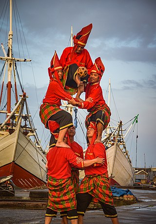
The Makassar or Makassarese people are an ethnic group that inhabits the southern part of the South Peninsula, Sulawesi in Indonesia. They live around Makassar, the capital city of the province of South Sulawesi, as well as the Konjo highlands, the coastal areas, and the Selayar and Spermonde islands. They speak Makassarese, which is closely related to Buginese, and also a Malay creole called Makassar Malay.
The Sultanate of Gowa was one of the great kingdoms in the history of Indonesia and the most successful kingdom in the South Sulawesi region. People of this kingdom come from the Makassar tribe who lived in the south end and the west coast of southern Sulawesi.

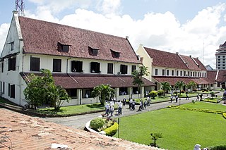
Fort Somba Opu was a fortified commercial center of the Gowa Sultanate. Its ruins are located in Makassar, South Sulawesi, Indonesia. The fort was the center of the Gowa Sultanate in the 16th-century until its destruction by the Dutch East India Company in 1669. The conquest of Somba Opu citadel was one of the most difficult campaigns the Company had ever undertaken in the East.
The Makassar kingdom of Gowa emerged around 1300 CE as one of many agrarian chiefdoms in the Indonesian peninsula of South Sulawesi. From the sixteenth century onward, Gowa and its coastal ally Talloq became the first powers to dominate most of the peninsula, following wide-ranging administrative and military reforms, including the creation of the first bureaucracy in South Sulawesi. The early history of the kingdom has been analyzed as an example of state formation.
The Kingdom of Tallo was one of the two kingdoms of Makassar in South Sulawesi from the 15th century to 1856. The state stood in a close political relation to the Sultanate of Gowa. After the Islamization of the Gowa and Tallo kingdoms in the early 17th century, they were usually collectively known as the Makassar Kingdom.

The Spermonde Archipelago is a group of around 120 islands off the southwest coast of Sulawesi in Indonesia, located within the Coral Triangle, between the southern arc of Sulawesi and the Strait of Makassar. They comprise two administrative districts within the Pangkajene and Islands Regency of Indonesia's South Sulawesi Province. Situated west of Makassar, the archipelago covers a land area of approximately 140 km2, and comprises around 50 vegetated islands and 70 unvegetated sand cays, of which 43 in total are named. About 50 islands are inhabited, collectively home to 31,293 people at the 2020 Census, and officially estimated at 33,379 as of mid-2023.