
Saline County is a county in the U.S. state of Nebraska. As of the 2010 United States Census, the population was 14,200. Its county seat is Wilber.

Vermilion County is a county in the eastern part of the U.S. state of Illinois, between the Indiana border and Champaign County. It was established in 1826 and was the 45th of Illinois' 102 counties. According to the 2010 United States Census, it had a population of 81,625, a decrease of 2.7% in 2000. It contains 21 incorporated settlements; the county seat and largest city is Danville.

Jackson County is a county located in the U.S. state of Illinois with a population of 60,218 at the 2010 United States Census. Its county seat is Murphysboro, and its most populous city is Carbondale, home to the main campus of Southern Illinois University. The county was incorporated on January 10, 1816 and named for Andrew Jackson. The community of Brownsville served as the fledgling county's first seat.

Gallatin County is a county located in the U.S. state of Illinois. According to the 2010 census, it has a population of 5,589, making it the fifth-least populous county in Illinois. Its county seat is Shawneetown. It is located in the southern portion of Illinois known locally as "Little Egypt".

Saline County is a county located in the U.S. state of Arkansas. As of the 2010 census, the population was 107,118. at the 2010 census. Its county seat and largest city is Benton. Saline County was formed on November 2, 1835, and named for the salt water (brine) springs in the area, however, it is pronounced "suh-LEAN" instead of the typical pronunciation, "SAY-lean". Until November 2014, it was an alcohol prohibition or dry county.
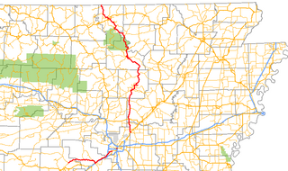
Highway 5 is a designation for three state highways in Arkansas. The southern segment of 44.99 miles (72.40 km) runs from Highway 7 in Hot Springs north to US Highway 70 (US 70) in Little Rock. A northern segment of 146.63 miles (235.98 km) begins at US Highway 67/US Highway 167 in Cabot and runs north to Missouri Route 5, including a lengthy overlap with Highway 25 between Heber Springs and Wolf Bayou. A portion of Highway 5 is designated as part of the Sylamore Scenic Byway.

Arkansas Highway 367 is a designation for two north–south state highways in Arkansas. A southern route of 15.03 miles (24.19 km) travels north from U.S. Route 167 (US 167) in East End north to US 70 in Little Rock. A northern route of 81.52 miles (131.19 km) begins in Cabot at US 67/AR 5/AR 321 and travels northeast to US 412 in Walnut Ridge.

Elba is an unincorporated community in North Fork Township, Gallatin County, Illinois, United States. Elba is located on the north fork of the Saline River, 4 miles (6.4 km) west-northwest of Ridgway.
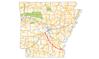
Arkansas Highway 35 is a northwest–southeast state highway in southeast Arkansas. The route runs 115.83 miles (186.41 km) from Dewey near the Mississippi River northwest to Arkansas Highway 5 in Benton.
Mitchellsville is an unincorporated community in Independence Township, Saline County, Illinois, United States. Mitchellsville is located along Illinois Route 34 and Illinois Route 145 6 miles (9.7 km) south of Harrisburg.
Pankeyville is an unincorporated community in Harrisburg Township, Saline County, Illinois, United States. Pankeyville is located along Illinois Route 34 and Illinois Route 145 2 miles (3.2 km) south of Harrisburg.
Cottage Grove is an unincorporated community in Cottage Township, Saline County, Illinois, United States. Cottage Grove is 4 miles (6.4 km) west-northwest of Equality.
Liberty is an unincorporated community in Harrisburg Township, Saline County, Illinois, United States. Liberty is located on County Route 37 along the southwestern border of Harrisburg.
Wasson is an unincorporated community in East Eldorado and Raleigh Townships, Saline County, Illinois, United States. Wasson is located along U.S. Route 45 3 miles (4.8 km) southwest of Eldorado.
New Hope is an unincorporated community in Brushy Township, Saline County, Illinois, United States. New Hope is 5.5 miles (8.9 km) southwest of Galatia.

Highway 298 is a designation for three state highways in Lower Arkansas. The eastern segment of 3.71 miles (5.97 km) begins at Sims at Highway 88 and runs southeast to US Route 270 (US 270). A middle segment of 28.39 miles (45.69 km) runs from Highway 27 at Story east to Highway 7. A segment in Saline County of 13.81 miles (22.23 km) runs east from Highway 9 to Highway 5 near Benton.
Texas City is an unincorporated community in Rector Township, Saline County, Illinois, United States. Texas City is located at the junction of U.S. Route 45 and County Highway 6 5 miles (8.0 km) north-northeast of Eldorado.
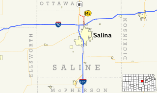
K-143 is a state highway in Saline County, Kansas. The route runs 4.658 miles (7.496 km) in a general north-south direction through lands mostly used for agriculture from an interchange at Interstate 70 (I-70) in northern Salina, Kansas to a junction with U.S. Route 81 (US-81). The southern part of the route is a four-lane divided highway while the rest is a two-lane highway. It has an annual average daily traffic (AADT) between 1,580 and 4,133 vehicles. The route is paved with three different pavement types, and is not a part of the National Highway System. It was first designated as US-81 Alternate in the early 1970s with the designation being changed to K-143 in the early 1980s.
West End is an unincorporated community in Franklin and Saline counties in the U.S. state of Illinois. The portion of the community in Franklin County is part of Cave Township, while the portion in Saline County is part of Tate Township. The community is located along Illinois Route 34 3.7 miles (6.0 km) east-southeast of Thompsonville.


