
Slovakia is a landlocked Central European country with mountainous regions in the north and flat terrain in the south.

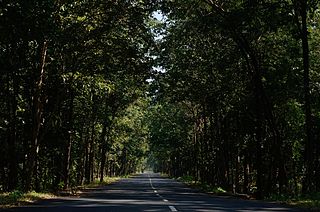
A ski resort is a resort developed for skiing, snowboarding, and other winter sports. In Europe, most ski resorts are towns or villages in or adjacent to a ski area – a mountainous area with pistes and a ski lift system. In North America, it is more common for ski areas to exist well away from towns, so ski resorts usually are destination resorts, often purpose-built and self-contained, where skiing is the main activity.

Banda District is a district of Uttar Pradesh state of India, and Banda is the district headquarters. It is a part of Chitrakoot Division.

Nelaug is a lake in the municipalities of Froland and Åmli in Aust-Agder county, Norway. The 10 kilometres (6.2 mi) lake is formed by a dam which regulates a hydroelectric power plant on the Nidelva river. The village of Nelaug is located near the dam in Froland municipality. The lake is located about 11 kilometres (6.8 mi) south of the village of Åmli, about 15 kilometres (9.3 mi) southeast of the village of Dølemo, and about 20 kilometres (12 mi) north of Blakstad.
Social forestry means the management and protection of forest and afforestation of barren and deforested lands with the purpose of helping environmental, social and rural development.

Ditrău is a commune in Harghita County, Romania. It is composed of three villages:

Kanathur is a village in Turvekere taluk of Tumkur district, in the Indian state of Karnataka. There is a Venugopalaswamy temple in Kanathur.Just next to the temple, there is a house in which the Patel of Kanathur, K.H.Adi Narayana Rao lived.
Hirekudi is a village in the southern state of Karnataka, India. It is located in the Chikodi taluk of Belgaum district in Karnataka.

Mullur is a village near Sarjapur road in Karnataka, India. It is in Bengaluru East Taluk, Bengaluru District in Karnataka. The nearest IT company is Wipro. There is another IT hub near the Varthur lake junction, which includes companies such as Nirvana. An adjacent village is Gunjur via Kachamaranahalli. The distance from Vidhana Soudha is 22 km.out of the village there is one school called Sri Sri Ravishankar vidhya mandir and there is a railway station 3.5 km from the village.

The following is a list of reportedly haunted locations in the United Kingdom.
Badachi is a village in Belgaum district in the southern state of Karnataka, India. It is located in Athani Taluka of Belgaum District, near Bijapur -Athani Highway. Maashahibi Darga is situated in the village managed by native Mulla(s) and an old mosque belonging Adil Shahi dynasty at the center of the village. Famous wrestling in village.
Basapur is a village in Hukeri taluk, Belgaum district in the southern state of Karnataka, India.
Buralatti is a village in the Athani tehsil of the Belgaum district in Karnataka, India with a population of about 4,000. The village's ruling assembly is located in Kokatnur.
Halashi (Halasi) is a historical village in Belgaum district in the southern state of Karnataka, India. It is about 45 kilometres away from Belgaum on the route to Dandeli, Goa.
Halolli is a village in Belgaum district in the southern state of Karnataka, India.
Yadurwadi is a village beside the Krishna River in Belagavi district in the southern state of Karnataka, India. Sugarcane is a main source of income for the people here. Farmers also grow soybeans in the monsoon season and wheat in the winter season. Yadurwadi is the part of Yadur Gram Panchayat. Neighbouring villages are Chandur, Shahapur, Khotwadi, Hale Yadur, Hosa Yadur and Khidrapur

Singra is a village in Kamrup rural district, situated near north bank of river Brahmaputra.
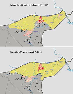
The Eastern al-Hasakah offensive was launched in the Al-Hasakah Governorate during the Syrian Civil War, by the Kurdish People's Protection Units, Assyrian Christian militias, and allied Arab forces against the jihadist Islamic State of Iraq and the Levant, with the intent of retaking the areas of the Jazira Canton that had been captured by ISIL. Subsequently, the Syrian Armed Forces also launched an assault against the radical militants, without coordinating with the Kurds.

The Raqqa campaign was a military operation launched by the Syrian Democratic Forces (SDF) against the Islamic State of Iraq and the Levant (ISIL) in the Raqqa Governorate, with the goal of isolating and eventually capturing the Islamic State's capital city, Raqqa. The SDF also completed their other main goals and captured the Tabqa Dam, the nearby city of al-Thawrah, and the Baath Dam further downstream.
Kallakurichi is one of the 33 districts which belong to Tamil Nadu state situated on the southern tip of India. The district headquarters is located at Kallakurichi. Kallakurichi district came into existence on 8 January 2019 when it was carved out of Villupuram district, which was then the largest district in the state before bifurcation.

