Sonoma Water

Last updated
Sonoma Water
Sonoma Water logo 2018.png
Agency overview
Formed1949
Website www.sonomawater.org

Sonoma Water, formerly known as the Sonoma County Water Agency, [1] maintains a water transmission system that provides naturally filtered Russian River water to more than 600,000 residents in portions of Sonoma County, California and Marin County, California. The Water Agency is a water wholesaler that sells potable water to nine cities and special districts that in turn sell drinking water to their residents. These cities and special districts are: the City of Santa Rosa, Rohnert Park, Cotati, Petaluma, Sonoma, the Town of Windsor, Valley of the Moon Water District, Marin Municipal Water District, and North Marin Water District. [2]

Contents

Mission

The mission of the Sonoma Water is to, "effectively manage the water resources in our care for the benefit of people and the environment through resource and environmental stewardship, technical innovation, and responsible fiscal management." [3]

Board of directors

The Sonoma County Board of Supervisors acts as the Sonoma Water's Board of Directors. The Water Agency is a separate legal entity created by State law, having specific limited purposes and powers, and separate sources of funding. The Water Agency is thus different from County departments, which are created by the Board of Supervisors for administrative purposes, but are not separate legal entities. [3]

Flood control

Sonoma Water was created as a special district in 1949 by the California Legislature to provide flood protection and water supply services. Providing flood protection is an important role in this community. The Water Agency has partnered with federal agencies to help build and manage a variety of flood protection projects, including Warm Springs Dam, Spring Lake, Coyote Valley Dam, Matanzas Creek Reservoir, Piner Creek Reservoir, Brush Creek Middle Fork Reservoir, and Spring Creek Reservoir. The Water Agency also manages a proactive stream maintenance program that maintains more than 80 miles of creeks throughout the area. [4]

Sanitation

In 1995, legislation made the Water Agency responsible for managing the county sanitation zones and districts, which provide wastewater collection and treatment, and recycled water distribution and disposal services for approximately 22,000 residences and businesses. The zones include Airport/Larkfield/Wikiup, Geyserville, Penngrove, and Sea Ranch. The sanitation districts include the Occidental, Russian River, Sonoma Valley, and South Park County Sanitation Districts [5]

Fisheries research and the Biological Opinion

The Russian River and its major tributaries is home to three species of fish that are threatened or endangered. These species are the Chinook salmon, the steelhead trout, and the coho salmon. Water Agency staff conducts fisheries research and monitoring activities to support ongoing Agency operations and Endangered Species Act compliance. The Russian River Biological Opinion is a federally mandated 15-year blueprint to help save endangered fish and ensure our water supply. [6]

Groundwater

The Water Agency is involved in a number of programs and initiatives to study the groundwater resources of the region through the Santa Rosa Plain Groundwater Program, the Sonoma Valley Groundwater Program, the Stormwater/Groundwater Recharge Program, and the Salt and Nutrient Management Plans. [7]

Water supply system

The Russian River begins in central Mendocino County, about 15 miles north of Ukiah. It drains 1,485 square miles watershed and it stretches 110 miles long. It reaches the Pacific Ocean at the town Jenner, which is located approximately 20 miles west of Santa Rosa. It flows southward until Mirabel Park where the direction changes to westward as it crosses part of the Coast Range. There are five principal tributaries: the East Fork of the Russian River, Big Sulphur Creek, Mark West Creek, Maacama Creek, and Dry Creek. [8]

Three major reservoir projects provide water supply for the Russian River watershed: Lake Pillsbury on the Eel River, Lake Mendocino on the East Fork of the Russian River, and Lake Sonoma on Dry Creek. Lake Mendocino and Lake Sonoma provide water for agriculture, municipal and industrial uses, in addition to maintaining the minimum stream flows required by Agency water rights permits. These minimum stream flows provide recreation and fish passage for salmon and steelhead. Most of the streamflow in the Russian River during the summer is provided by water imported from the Eel River. Streamflows are augmented by releases from Lake Mendocino and Lake Sonoma. [8]

Scott Dam and Lake Pillsbury

Scott Dam is a concrete gravity dam on the Eel River captures a drainage area of 298 square miles and forms Lake Pillsbury. Lake Pillsbury has a storage capacity of 86,388 acre-feet. Since 1923, the lake stored water for diversion to PG&E's Potter Valley Hydroelectric powerhouse through a tunnel constructed through a mountain ridge. Outflow from the powerhouse flows into the East Fork of the Russian River [8]

Coyote Valley Dam and Lake Mendocino

Located on the East Fork of the Russian River, Coyote Dam is a rolled earth embankment dam that forms Lake Mendocino. Lake Mendocino is a U.S. Army Corps of Engineers project that began storing water in 1959. It captures a drainage area of about 105 square miles, and provides a total storage capacity of 118,000 acre-feet with a water supply pool of 70,000 acre-feet. [8]

Warm Springs Dam and Lake Sonoma

https://commons.wikimedia.org/wiki/File%3ASonoma_Lake_aerial_view.jpg

Located about 14 miles northwest of Healdsburg, Warm Springs Dam is a rolled earth embankment dam that forms Lake Sonoma. The Sonoma County Water Agency generates electricity at Warm Springs Dam through a hydroelectric turbine. Located at the confluence of Warm Springs Creek and Dry Creek, this lake began storing water in 1984 and has a total storage capacity of 381,000 acre-feet with a water supply pool of 212,000 acre-feet. [8]

Warm Springs Dam is a multi-purpose reservoir serves as a flood control, water supply and recreational facility. The Water Agency is the local cost-sharing partner for Warm Springs Dam, and determines the amount of water to be released when the lake level is in the water supply pool, and the US Army Corps of Engineers manages flood control releases. [8]

Transport

Russian River Wfm russian river.jpg
Russian River

Customers

Sonoma Water is a water wholesaler that primarily sells potable water to nine municipalities and water districts in two counties: [10]

Additionally, there are several smaller water companies and districts in Sonoma County that also receive water from the Agency. These include:

Organization

Formed on October 1, 1949 by Chapter 994 of the California Statues of 1949, the Agency was originally called the Sonoma County Flood Control and Water Conservation District. [9] It has grown with the region it serves and now has an annual budget of over $170 million and employs 197 full-time equivalents. [11]

Although its board of directors is identical to the county's Board of Supervisors, the Agency is a separate legal entity with its own funding. [10] Since 1961, its board has had the right to sell bonds without voter approval. [12]

Its administrative offices are located at 404 Aviation Boulevard in Santa Rosa: 38°30′42″N122°47′1″W / 38.51167°N 122.78361°W / 38.51167; -122.78361 Coordinates: 38°30′42″N122°47′1″W / 38.51167°N 122.78361°W / 38.51167; -122.78361 . [13]

Awards

In 2009 the Sonoma County Water Agency was honored with the California Sustainability Alliance's Sustainability Showcase Award. [14] The award commended the Water Agency for their commitment to Carbon-Free Water by 2015 and for their use in innovative sustainability practices, programs, technologies and policies. [15]

See also

Related Research Articles

<span class="mw-page-title-main">Sonoma County, California</span> County in California, United States

Sonoma County is a county located in the U.S. state of California. As of the 2020 United States Census, its population was 488,863. Its county seat and largest city is Santa Rosa. It is to the north of Marin County and the south of Mendocino County. It is west of Napa County and Lake County.

<span class="mw-page-title-main">Lake Sonoma</span> Body of water

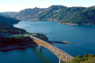
Lake Sonoma is a reservoir west of Cloverdale in northern Sonoma County, California, created by the construction of Warm Springs Dam. Access from U.S. Route 101 is by way of Canyon Road from Geyserville, or Dutcher Creek Road from Cloverdale.

<span class="mw-page-title-main">Coyote Creek (Santa Clara County)</span> Archaeological site in California, United States

Coyote Creek is a river that flows through the Santa Clara Valley in Northern California. Its source is on Mount Sizer, in the mountains east of Morgan Hill. It eventually flows into Anderson Lake in Morgan Hill and then northwards through Coyote Valley to San Jose, where it empties into San Francisco Bay.

<span class="mw-page-title-main">Mokelumne River</span> River in northern California

The Mokelumne River is a 95-mile (153 km)-long river in northern California in the United States. The river flows west from a rugged portion of the central Sierra Nevada into the Central Valley and ultimately the Sacramento–San Joaquin River Delta, where it empties into the San Joaquin River-Stockton Deepwater Shipping Channel. Together with its main tributary, the Cosumnes River, the Mokelumne drains 2,143 square miles (5,550 km2) in parts of five California counties. Measured to its farthest source at the head of the North Fork, the river stretches for 157 miles (253 km).

<span class="mw-page-title-main">Yuba River</span> Waterway in Northern California

The Yuba River is a tributary of the Feather River in the Sierra Nevada and eastern Sacramento Valley, in the U.S. state of California. The main stem of the river is about 40 miles (64 km) long, and its headwaters are split into three major forks. The Yuba River proper is formed at the North Yuba and Middle Yuba rivers' confluence, with the South Yuba joining a short distance downstream. Measured to the head of the North Yuba River, the Yuba River is just over 100 miles (160 km) long.

<span class="mw-page-title-main">Cache Creek (Sacramento River tributary)</span> Stream from Lake to Yolo Counties, CA

Cache Creek is an 87-mile-long (140 km) stream in Lake, Colusa and Yolo counties, California.

<span class="mw-page-title-main">Gualala River</span> River in California, United States

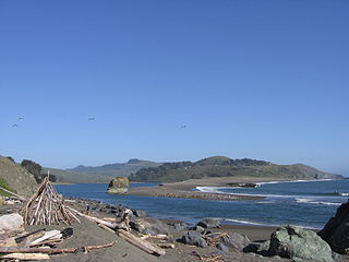
The Gualala River is a river on the northern coast of California. Most of the river is in Sonoma County, but a portion is in Mendocino County. The headwaters of the 40-mile-long (64 km) river are high in the Coast Range, and it empties into the Pacific Ocean. For its last few miles, it forms the boundary between Sonoma County and Mendocino County.

<span class="mw-page-title-main">Lake Mendocino</span> Man-made lake in California, United States

Lake Mendocino is a large reservoir in Mendocino County, California, northeast of Ukiah. It covers 1,922 acres (7.78 km2) and was formed by the construction of Coyote Valley Dam in 1958. The lake and dam provide flood control, water conservation, hydroelectric power, and recreation. The dam also includes a fallout shelter built during the Cold War era to protect against the radiation from nuclear attacks from the Soviet Union.

<span class="mw-page-title-main">Russian River (California)</span> River in California

The Russian River is a southward-flowing river that drains 1,485 sq mi (3,850 km2) of Sonoma and Mendocino counties in Northern California. With an annual average discharge of approximately 1,600,000 acre feet (2.0 km3), it is the second-largest river flowing through the nine-county Greater San Francisco Bay Area, with a mainstem 115 mi (185 km) long.

<span class="mw-page-title-main">Matanzas Creek</span> River in California, United States

Matanzas Creek is an 11.4-mile-long (18.3 km) year-round stream in Sonoma County, California, United States, a tributary of Santa Rosa Creek.

The Santa Clara Valley Water District provides stream stewardship, wholesale water supply and flood protection for Santa Clara County, California, in the southern San Francisco Bay Area. The district encompasses all of the county's 1,300 square miles (3,400 km2) and serves the area's 15 cities, 2 million residents and more than 200,000 commuters. In terms of acres, the district includes 138,000 acres, and 120,700 of those acres are lands that people have built cities, roads or cultivate farms on. Almost 2,000 pumping wells supply the districts fields, houses and businesses with a clean reliable source of water. The water district has about 150 miles of pipelines and operates 10 dams and reservoirs, three treatment plants, many groundwater recharge basins, three pump stations and an advanced water purification plant. The district's three water treatment plants can produce as much as 210,000,000 US gallons (800,000 m3) of drinking water a day.

<span class="mw-page-title-main">Spring Lake Regional Park</span>

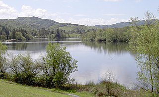
Spring Lake Regional Park is a 320-acre (130 ha) public park in southeastern Santa Rosa, Sonoma County, California, United States. Centered on the Santa Rosa Creek Reservoir, the park is administered by the Sonoma County Regional Parks Department. Its coordinates are 38.45°N 122.65°W, and its official address is 391 Violetti Drive.

The Central Utah Project is a US federal water project that was authorized for construction under the Colorado River Storage Project Act of April 11, 1956, as a participating project. In general, the Central Utah Project develops a portion of Utah's share of the yield of the Colorado River, as set out in the Colorado River Compact of 1922.

<span class="mw-page-title-main">East Fork Russian River</span> River in California, United States

East Fork Russian River is a 15 mi (24 km) long tributary of the Russian River in Mendocino County, California artificially connected to the Eel River via an interbasin diversion at the Potter Valley Project hydroelectric facility. It forms in the north of Potter Valley, flows south through this valley, then southwest through a mountain pass to Lake Mendocino, an artificial reservoir that empties into Russian River. At one time Clear Lake to the east drained through Cold Creek then along the lower part of East Fork Russian River through Coyote Valley to the Russian River proper. A few hundred years ago a massive landslide blocked this channel, and Clear Lake found a new outlet to the Sacramento River.

The Marin Municipal Water District is the government agency that provides drinking water to southern and central Marin County, California. Chartered in 1912, it became California's first municipal water district. It serves 191,000 customers in a 147-square-mile (380 km2) area that includes ten towns and cities.

<span class="mw-page-title-main">Lake Van Arsdale</span> Body of water

Lake Van Arsdale, also known as Van Arsdale Reservoir, is a reservoir on the Eel River in California, part of the Potter Valley Project. Located in Mendocino County, 4 miles (6.4 km) north of the town of Potter Valley, California, the reservoir supplies water to users as far south as Marin County.

<span class="mw-page-title-main">Potter Valley Project</span>

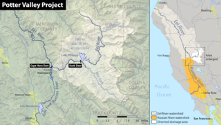
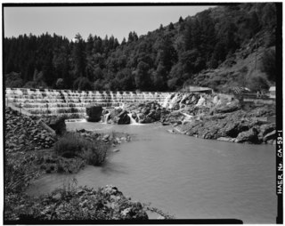
The Potter Valley Project is an hydroelectric project in Northern California in the United States, delivering water from the Eel River basin to turbines in the headwaters of the Russian River. The project is owned and operated by Pacific Gas and Electric Company (PG&E). The main facilities are two dams on the Eel River, a diversion tunnel and hydroelectric plant. Average annual throughput is 159,000 acre⋅ft (196,000,000 m3), although this figure varies significantly with both the amount of precipitation in the Eel River basin and the demand on the Russian River.

<span class="mw-page-title-main">Mojave Forks Dam</span> Dam in Hesperia, California

The Mojave Forks Dam, most often known as the Mojave River Dam, is an earth-fill dry dam across the Mojave River in San Bernardino County, California in the United States. Completed in 1974 by the U.S. Army Corps of Engineers (USACE), the dam is located at the confluence of the West Fork Mojave River and Deep Creek, and can store approximately 179,400 acre⋅ft (221,300,000 m3) of water.

<span class="mw-page-title-main">2017 California floods</span> Regional natural disaster event

The 2017 California floods affected parts of California in the first half of the year. Northern California saw its wettest winter in almost a century, breaking the record set in 1982–83. The same storm systems also flooded parts of western Nevada and southern Oregon. The damage was estimated at $1.55 billion ($1,713,501,222 today), including damage to California roads and highways estimated at more than $1.05 billion.

References

  1. "Sonoma Water". scwa.ca.gov. 2018. Retrieved September 22, 2018.
  2. "Water Resources". Archived from the original on 2014-09-13.
  3. 1 2 "Sonoma Water - About Us".
  4. "Sonoma Water - Flood Protection".
  5. "Sonoma Water - Sanitation".
  6. "Sonoma Water - Russian River Biological Opinion".
  7. "Sonoma Water - Groundwater".
  8. 1 2 3 4 5 6 "Sonoma Water - Water Supply".
  9. 1 2 Beach, Robert F. (2002). "History of the Development of the Water Resources of the Russian River" . Retrieved July 3, 2010.
  10. 1 2 "Quick Facts - Sonoma County Water Agency" . Retrieved July 3, 2010.
  11. "SCWA Organizational Chart" (PDF). Retrieved July 3, 2010.
  12. "So Co Water Agency Structure" . Retrieved July 3, 2010.
  13. "Contact Us" . Retrieved July 3, 2010.
  14. California Sustainability Alliance, Sustainability Showcase Awards, Received October 28th, 2010
  15. California Sustainability Alliance, Sonoma County Water Agency, Received October 28th, 2010