
The Battle of Tampere was a 1918 Finnish Civil War battle, fought in Tampere, Finland from 15 March to 6 April between the Whites and the Reds. It is the most famous and the heaviest of all the Finnish Civil War battles. Today it is particularly remembered for its bloody aftermath as the Whites executed hundreds of capitulated Reds and took 11,000 prisoners who ended up in the Kalevankangas camp.

Tampere Central Station is a functionalist building in Tampere, Finland, designed by Eero Seppälä and Otto Flodin, completed in 1936. The station is one of the most important railway stations in Finland. In 2015, the Tampere Central Station was the second busiest railway station in Finland in terms of numbers of passengers, after the Helsinki Central Station.
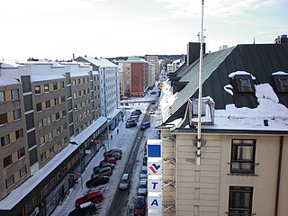
Hallituskatu is an east–west street running through the districts of Nalkala and Kaakinmaa, in the centre of Tampere, Finland. Its end point in the east is the cartboard factory area of Metsä Board Tako.

Atala is a neighbourhood in the northeast part of the city of Tampere, Finland, a few kilometers to the east from the border of the Kangasala city. Its neighboring neighborhoods are Holvasti in the south, Linnainmaa in the southwest and Tasanne in the north. The district was named after Ata Oy, which was founded in 1937 and manufactures spiral bevel gears.
Teiskontie is a street and highway in Tampere, Finland. As its name implies, it runs from the center of Tampere towards Teisko, a former municipality connected to Tampere in 1972. To the east of the highway junction of Hervanta, it is part of Highway 12 leading in the direction of Lahti and Kouvola. On the east side of Lake Alasjärvi, Teiskontie has a connection to Highway 9 (E63) leading in the direction of Jyväskylä and Kuopio.

Liisankallio is a district of Tampere, Finland. The district, formerly known as Tammelan vainio, is located east of the Tammela and Tulli districts. To the north is the Petsamo district, to the east are Kaleva and Kalevanrinne, to the south is Kalevanharju. When we often talk about Kaleva, we mean a larger entity formed by Liisankallio, Kaleva and Kalevanrinne.

Sammonkatu is a wide park street in the Kaleva district in Tampere, Finland. It starts at the intersection of Itsenäisyydenkatu and Teiskontie. The street is part of Kaleva's nationally significant built cultural environment. Along it is, among other things, Sampola, a public building with Sampola Library and Tammerkoski High School.

Keskusta is a main district of the city of Tampere, Finland, formed by less than 20 suburbs in the city centre. Over 63,000 people live in Keskusta. It is located along the Tammerkoski rapids and its most important services include Tampere City Hall and the Market Hall.

Itsenäisyydenkatu is an east–west street in the center of Tampere, Finland. It is a significant street connection in the city center of Tampere in terms of transport connections, as it leads from Tampere's railway station to the Liisankallio district in the Tammela district. On the west side of the station, the street continues as the Hämeenkatu street, at its eastern end it meets Kalevan puistokatu, branching into Teiskontie and Sammonkatu. Today, the only crossroads on Itsenäisyydenkatu with cross-street vehicle traffic is Tammelan puistokatu–Yliopistonkatu.

Tammelantori is a market square in the Tammela district in the center of Tampere in Pirkanmaa, Finland. It is one of Tampere's most significant marketplaces, which is very popular, especially during the summer. The market is very famous for its cafes and mustamakkara kiosks.

Hakametsä is a smaller district of Tampere, Finland, located about four kilometers from its city center. The neighboring parts of Hakametsä are Huikas, Ristinarkku, Messukylä, Vuohenoja, Kalevanrinne, Kaleva, Kissanmaa and Uusikylä.

Aakkula is a smaller district in Tampere, Finland, located about four kilometers from its city center. Aakkula is bordered on the west by Vuohenoja, on the east by Viiala, on the south by Turtola and on the north by Messukylä. In 2012, Aakkula had 465 inhabitants.

Yliopistonkatu is a north–south street in the Tulli district of Tampere, Finland. The street is a southern extension of Tammelan puistokatu, which starts at Itsenäisyydenkatu and extends south to Kalevantie. It is 400 meters long. To the east of the street is the Sorsapuisto park area and the Tampere Hall, a concert and congress center completed in 1990.

Näsilinna is a neo-baroque palace on Näsikallio in Tampere, Finland. It was built by Peter von Nottbeck, son of Wilhelm von Nottbeck, a St. Petersburg-based industrial manager of Finlayson. The original name of the palace, completed in 1898, was Milavida. The building was designed by architect Karl August Wrede. The true meaning and history of the name Milavida is unknown.

Tuomiokirkonkatu is a north–south street in the center of Tampere, Finland, which runs through the districts of Jussinkylä and Kyttälä. The street is about a kilometer long. In the north it ends at Lapintie, in the south Vuolteenkatu. In Kyttälä, part of Tuomiokirkonkatu has been turned into a pedestrian street. In the future, the pedestrian section will be expanded so that it will eventually extend south from Kyttälänkatu to Suvantokatu and the Sori Square.
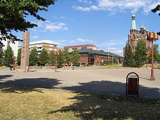
The Sori Square is a square located in the center of Tampere, Finland, in the southern part of the Kyttälä district. It is located in the area bounded by the Hatanpää Highway, Suvantokatu, Tuomiokirkonkatu and Vuolteenkatu. At the eastern end of the square is the Tampere Orthodox Church from 1898. There is a terminus at Tampere Tram Line 1 on the west side.

Pyynikinrinne is a district of Tampere, Finland. It is located west of the city center. Pyynikinrinne is bordered on the south by the Pyynikki Esker nature reserve, on the north by Pirkankatu and on the east by Mariankatu. The western boundary of the district is the former border between Tampere and Pohjois-Pirkkala municipalities. The neighboring parts of the city are Pyynikki, Ylä-Pispala, Amuri, partly Särkänniemi and Kaakinmaa.

Satakunnankatu is an east–west, busy street in the center of Tampere, Finland, which is one of the city's main streets. It starts from the vicinity of Tampere Cathedral on the east side of Tammerkoski, where it separates the Jussinkylä and Kyttälä Districts. The street crosses the rapids along the Satakunta Bridge (Satakunnansilta) and runs on the west side between Finlayson and the Hämeenpuisto park. From there it continues through the Amuri area to the Pirkankatu street.

Petsamo is a district of Tampere, Finland. The district is named after Pechenga, which Finland acquired in the Treaty of Tartu. At the same time as Soviet Russia ceded Petsamo to Finland in 1920, some large Tamperean industrial plants began to build a residential area for their working population on the northeast corner of the city. When the area seemed to be far from the center, the informal name of the district was born as a result of the image.

Lapinniemi is a district in the northern part of Tampere, Finland. It is located on a peninsula formed on the shores of Lake Näsijärvi. Neighboring parts of the city are Petsamo, Lappi and Tampella. It is about a kilometer from the city center of Tampere to Lapinniemi, but it takes about five minutes by bus through Tammela and 10 minutes to the Central Square.


