
Tampere is a city in Pirkanmaa in the western part of Finland. Tampere is the most populous inland city in the Nordic countries; it has a population of 238,140 with the urban area holding 334,112 people and the metropolitan area, also known as the Tampere sub-region, holding 385,301 inhabitants in an area of 4,970 km2 (1,920 sq mi). Tampere is the second-largest urban area and third most-populous individual municipality in Finland, after the cities of Helsinki and Espoo and the most populous Finnish city outside the Greater Helsinki area, within which both Helsinki and Espoo are located. Today, Tampere is one of the major urban, economic, and cultural hubs in the whole inland region.
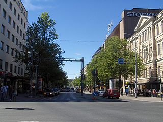
Hämeenkatu is the main street of Tampere, Finland, located in the city center. The boulevard is roughly a kilometre long, and 28.5 metres (94 ft) wide at its widest point.

Kyttälä is a district in Tampere, Finland. It was born in the late 1870s as a working-class neighborhood to the eastern outskirts of the town. As Tampere soon expanded, Kyttälä is now a part of the city center between the Tammerkoski river and the railway. Population of Kyttälä is 3,348. Aleksanterinkatu is one of Kyttälä's main streets. The direct connection to the Liisankallio district and from there to Teiskontie and Sammonkatu streets runs along Itsenäisyydenkatu and connection to the Jussinkylä district runs along Tuomiokirkonkatu.

Nalkala is a neighbourhood in the city of Tampere, Finland, covering the southern part of the city center from Hämeenkatu to the Laukontori market square. The district is bordered by the lower reaches of Tammerkoski, the Ratina estuary, Lake Pyhäjärvi and to the west by Hämeenpuisto. The original 19th-century street names in the area still include Hämeenkatu, Hallituskatu and Kuninkaankatu, the latter been named after the founder of the city of Tampere, King Gustav III of Sweden. The area is named after two houses called Nalka, which were mentioned in the 1540 land register.
Jussinkylä is a neighbourhood in the city center of Tampere, Finland. It is located east of Tammerkoski and borders Satakunnankatu in the south. To the east and northeast, the district is bounded by a railway and to the northwest by Lapintie. The Erkkilä Bridge connects Jussinkylä to Tammela. The most significant landmarks in the area are Tampere Cathedral and Tampere Central Fire Station. Neighboring neighborhoods are Finlayson, Tampella and Kyttälä, from which the latter runs a route along the Tuomiokirkonkatu street.

Keskusta is a main district of the city of Tampere, Finland, formed by less than 20 suburbs in the city centre. Over 63,000 people live in Keskusta. It is located along the Tammerkoski rapids and its most important services include Tampere City Hall and the Market Hall.

Itsenäisyydenkatu is an east-west street in the center of Tampere, Finland. It is a significant street connection in the city center of Tampere in terms of transport connections, as it leads from Tampere's railway station to the Liisankallio district in the Tammela district. On the west side of the station, the street continues as the Hämeenkatu street, at its eastern end it meets Kalevan puistokatu, branching into Teiskontie and Sammonkatu. Today, the only crossroads on Itsenäisyydenkatu with cross-street vehicle traffic is Tammelan puistokatu–Yliopistonkatu.

Kämmenniemi is a district, a statistical area and an urban area of Tampere, Finland, located in the area of the former municipality of Teisko. The regional road 338 between Tampere and Ruovesi runs through Kämmenniemi. The distance from the village to the city center of Tampere is about 25 kilometers. The most important sights and buildings in Kämmenniemi are, for example, the Aunessilta arch bridge and Kämmenniemi School. Among other things, the annual Teisko market is organized in Kämmenniemi. Kämmenniemi also has a library and fire station of the Teisko's volunteer fire department. The Paarlahti bay is also located in Kämmenniemi, which is called the only fjord in Finland; however, according to official definitions, it does not quite meet the characteristics of a fjord.

Tahmela is a district in Tampere, Finland. It is located between Ylä-Pispala and Pyynikki on the shores of Lake Pyhäjärvi. There is a Varala Sports College in Tahmela. There are rental agricultural plots on the shore of Tahmela, and Kurpitsaliike ry was founded in 1998 to defend the continuation of land cultivation in Tahmela.
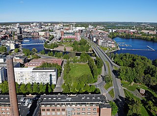
Ratina is a district in the center of Tampere, Finland, on the east side of Tammerkoski. The Ratina Stadium, Tampere Bus Station and Tampere's largest shopping mall, the Ratina shopping centre, are located in the district, among others. To the north of Ratina is also the Koskikeskus shopping centre. The district consists of a peninsula called Ratinanniemi, which is surrounded on three sides by Ratinansuvanto and Viinikanlahti. Between Ratinanniemi and the Laukontori square is a pedestrian bridge called Laukonsilta, which significantly shortens travel time to the city center. The Tampere highway has good connections to the Helsinki-Tampere motorway and along it to the Tampere Ring Road, and via the Ratinansilta bridge and the Hämeenpuisto park to Highway 12. Ratinanranta is the southern part of the Tampere highway from Ratina, which used to be a recreation ground and factory area. Its new construction into a dense apartment building area of 1,000 inhabitants began in 2008, and the latest residential buildings east of the Voimakatu street are expected to be completed in 2013.

Laukontori is a market square in the southern part of the city center of Tampere, Finland, on the shores of Lake Pyhäjärvi. It is located just a few hundred meters from Tampere Central Square. Square's beach serves as a harbor for cruise ships to the Viikinsaari island and the city of Hämeenlinna in the summer.

Viinikka is a district of Tampere, Finland, located 1,5 kilometers southeast of its city center on the west side of Lake Iides. Its neighboring district is Nekala. Its construction began in 1914 on the former lands of Hatanpää Manor. The stone church, opened in 1932, is located in Viinikka.
Linnainmaa is a district of about 6,000 inhabitants in the eastern part of Tampere, Finland, about six kilometers from the city center. Tampere's eastern bypass borders Linnainmaa in the west, and Highway 12 in the north. The building stock of Linnainmaa consists mainly of detached houses built in the 1950s and 1960s, as well as newer detached, multi-storey and terraced houses. The average age of those living in Linnainmaa is 40.9 years. The largest age group is 30-49 years old. The majority of the residents of the district are employed, the second largest are pensioners.

Kissanmaa is a district in the eastern part of Tampere, Finland, along the Teiskontie street. It belongs to the subdivision of Sampo, and it is located 3 kilometers from the city center. Kissanmaa is surrounded by Ruotula and Uusikylä in the east, Hakametsä in the south, Kaleva in the west and Kauppi in the north. Most of the residential houses are detached houses, but there are also apartment buildings of different sizes in the western part of the area. The area is best known for Finland's first ice rink, Tampere Ice Stadium, and training hall, completed in 1965. The first town plan of Kissanmaa was established in 1958.
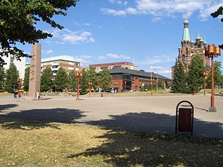
The Sori Square is a square located in the center of Tampere, Finland, in the southern part of the Kyttälä district. It is located in the area bounded by the Hatanpää Highway, Suvantokatu, Tuomiokirkonkatu and Vuolteenkatu. At the eastern end of the square is the Tampere Orthodox Church from 1898. There is a terminus at Tampere Tram Line 1 on the west side.

Pyynikinrinne is a district of Tampere, Finland. It is located west of the city center. Pyynikinrinne is bordered on the south by the Pyynikki Esker nature reserve, on the north by Pirkankatu and on the east by Mariankatu. The western boundary of the district is the former border between Tampere and Pohjois-Pirkkala municipalities. The neighboring parts of the city are Pyynikki, Ylä-Pispala, Amuri, partly Särkänniemi and Kaakinmaa.

Kaakinmaa is a district in Tampere, Finland, located in the city center. It includes the area south of Pyynikki Church Park between the Hämeenpuisto park and the Mariankatu street. To the south, the area extends to Eteläpuisto on the shores of Lake Pyhäjärvi. The neighboring parts of the city are Nalkala in the east, Amuri in the north and Pyynikki and Pyynikinrinne in the west. Sometimes Kaakinmaa is incorrectly considered to belong to Pyynikki and Pyynikinrinne; however, Kaakinmaa has its own district.

Pirkankatu is a busy, east-west street located in Tampere, Finland, which forms the southern border of the Amuri district. The districts of Kaakinmaa and Pyynikinrinne are located south of the street. To the east, the end of Pirkankatu is the Hämeenpuisto park, in the middle stages of which it connects to Hämeenkatu. In the west, on the border of Pispala, Pirkankatu becomes the Pispala Highway.

Satakunnankatu is an east-west, busy street in the center of Tampere, Finland, which is one of the city's main streets. It starts from the vicinity of Tampere Cathedral on the east side of Tammerkoski, where it separates the Jussinkylä and Kyttälä Districts. The street crosses the rapids along the Satakunta Bridge (Satakunnansilta) and runs on the west side between Finlayson and the Hämeenpuisto park. From there it continues through the Amuri area to the Pirkankatu street.
Kalevanharju is a district of Tampere, Finland. It is bordered on the north by Liisankallio, on the northeast by Kaleva, on the east by Kalevanrinne, on the south by Hatanpää, on the west by Ratina and on the northwest by Tulli. The Central Campus of the Tampere University, the Kalevankangas Cemetery and the Tampere Adult Education Center are located in Kalevanharju.

