
Tampere is a city in the Pirkanmaa region, located in the western part of Finland. Tampere is the most populous inland city in the Nordic countries. It has a population of 244,029; the urban area has a population of 341,696; and the metropolitan area, also known as the Tampere sub-region, has a population of 393,941 in an area of 4,970 km2 (1,920 sq mi). Tampere is the second-largest urban area and third most-populous individual municipality in Finland, after the cities of Helsinki and Espoo, and the most populous Finnish city outside the Greater Helsinki area. Today, Tampere is one of the major urban, economic, and cultural hubs in the whole inland region.

The city of Tampere, the second largest city and urban area of Finland after Helsinki, can be divided into various sorts of subdivisions. The subdivisions include neighbourhoods, districts, major districts and postal code areas. The plethora of different official ways to divide the city is a source of some confusion to the inhabitants, as different kinds of subdivisions often share similar or identical names.

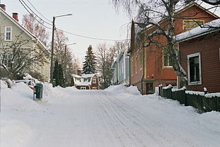
Nalkala is a neighbourhood in the city of Tampere, Finland, covering the southern part of the city center from Hämeenkatu to the Laukontori market square. The district is bordered by the lower reaches of Tammerkoski, the Ratina estuary, Lake Pyhäjärvi and to the west by Hämeenpuisto. The original 19th-century street names in the area still include Hämeenkatu, Hallituskatu and Kuninkaankatu, the latter been named after the founder of the city of Tampere, King Gustav III of Sweden. The area is named after two houses called Nalka, which were mentioned in the 1540 land register.

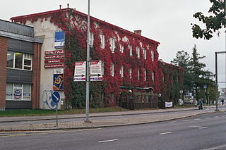
Tampella is a neighbourhood in the northern part of the city center of Tampere, Finland. It consists of the old Tampella factory area, the Armonkallio residential area and the Naistenlahti harbor area. The neighboring parts of the internally heterogeneous district located on the shores of Lake Näsijärvi are Lapinniemi, Lappi, Osmonmäki, Tammela, Jussinkylä, Finlayson and Särkänniemi.

Särkänniemi is a district of the city centre of Tampere, Finland, located on the shores of Lake Näsijärvi, north of the districts of Amuri and Finlayson. The most famous sights of the district are Näsinneula and Särkänniemi Amusement Park, but in addition to that, the district also houses the Haarla's old paper mill building. The Amuri railway stop has also ceased operations in Särkänniemi. The Särkänniemi district also includes the Siilinkari islet in Lake Näsijärvi. Särkänniemi is bordered on the south by Paasikivenkatu, on the other side of which is the Amuri district, and on the west by the Santalahti district. The district includes the Onkiniemi residential area.

Keskusta is a main district of the city of Tampere, Finland, formed by less than 20 suburbs in the city centre. Over 63,000 people live in Keskusta. It is located along the Tammerkoski rapids and its most important services include Tampere City Hall and the Market Hall.

Takahuhti is a district in Tampere, Finland. It is located in eastern part of the city, close to Atala, Linnainmaa, Kissanmaa and Messukylä. There are many prehistoric residences and finds in the area. Takahuhti was the largest village in Messukylä from the Middle Ages to the 20th century. The Battle of Tampere was also fought in Takahuhti during the 1918 civil war. The area is dominated by detached houses and there is a school built in 1939.
Lappi is a district in Tampere, Finland, near the Lake Näsijärvi and the Kauppi's park area. About 700 people live there. When talking about Lappi, reference is usually made to the Lapinniemi district. The district is home to the Koukkuniemi's nursing home, which is one of the largest nursing homes in Europe. There are also yacht clubs in the area and a spa and apartments in an old factory building were completed for the 1990 housing fair.
Hatanpää is a district in Tampere, Finland, located in the southern part of the city center on the shores of Lake Pyhäjärvi. Hatanpää is actually a peninsula that protrudes towards the lake, leaving the waters of Viinikanlahti Bay to the north and Vihilahti Bay to the south. The area is named after Hatanpää Manor, whose land from Härmälä to Sääksjärvi and Nekala was bought for the city in 1913. Administratively, the area has belonged to the city since 1920. In 2014, the population of the area was measured as 2,686 inhabitants.

Aakkula is a smaller district in Tampere, Finland, located about four kilometers from its city center. Aakkula is bordered on the west by Vuohenoja, on the east by Viiala, on the south by Turtola and on the north by Messukylä. In 2012, Aakkula had 465 inhabitants.

Kämmenniemi is a district, a statistical area and an urban area of Tampere, Finland, located in the area of the former municipality of Teisko. The regional road 338 between Tampere and Ruovesi runs through Kämmenniemi. The distance from the village to the city center of Tampere is about 25 kilometers. The most important sights and buildings in Kämmenniemi are, for example, the Aunessilta arch bridge and Kämmenniemi School. Among other things, the annual Teisko market is organized in Kämmenniemi. Kämmenniemi also has a library and fire station of the Teisko's volunteer fire department. The Paarlahti bay is also located in Kämmenniemi, which is called the only fjord in Finland; however, according to official definitions, it does not quite meet the characteristics of a fjord.

Multisilta is the southern suburb of Tampere, Finland, about eight kilometers from its city center. Multisilta was built from the late 1960s to the 1990s. The district has a population of about 3,000. In the center there is a pub, a grocery store, a youth center and a kebab pizzeria grill. There is a water tower to the north of the residential area. Multisilta borders the Peltolammi district in the north and the Vuores district in the east. In the south you will meet the Lempäälä border and in the west the Pirkkala border. To the east, the district is bordered by the end of Vuoreksenkatu and the Highway 3 (E12). Multisilta can be reached by public transport buses 15 and 50 in the Tampere region.

Lentävänniemi is a district in the western part of Tampere on the shores of Lake Näsijärvi in Pirkanmaa, Finland. It belongs to the northwestern part of the city and borders the Niemi and Niemenranta borders on the southwest. There are jogging paths along the lake and its shores surrounding the apartment-based Lentävänniemi. In 2014, the population of Lentävänniemi was 4,309.
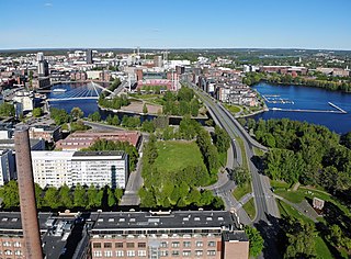
Ratina is a district in the center of Tampere, Finland, on the east side of Tammerkoski. The Ratina Stadium, Tampere Bus Station and Tampere's largest shopping mall, the Ratina shopping centre, are located in the district, among others. To the north of Ratina is also the Koskikeskus shopping centre. The district consists of a peninsula called Ratinanniemi, which is surrounded on three sides by Ratinansuvanto and Viinikanlahti. Between Ratinanniemi and the Laukontori square is a pedestrian bridge called Laukonsilta, which significantly shortens travel time to the city center. The Tampere highway has good connections to the Helsinki-Tampere motorway and along it to the Tampere Ring Road, and via the Ratinansilta bridge and the Hämeenpuisto park to Highway 12. Ratinanranta is the southern part of the Tampere highway from Ratina, which used to be a recreation ground and factory area. Its new construction into a dense apartment building area of 1,000 inhabitants began in 2008, and the latest residential buildings east of the Voimakatu street are expected to be completed in 2013.

Laukontori is a market square in the southern part of the city center of Tampere, Finland, on the shores of Lake Pyhäjärvi. It is located just a few hundred meters from Tampere Central Square. Square's beach serves as a harbor for cruise ships to the Viikinsaari island and the city of Hämeenlinna in the summer.

Viinikka is a district of Tampere, Finland, located 1,5 kilometers southeast of its city center on the west side of Lake Iides. Its neighboring district is Nekala. Its construction began in 1914 on the former lands of Hatanpää Manor. The stone church, opened in 1932, is located in Viinikka.

Kissanmaa is a district in the eastern part of Tampere, Finland, along the Teiskontie street. It belongs to the subdivision of Sampo, and it is located 3 kilometers from the city center. Kissanmaa is surrounded by Ruotula and Uusikylä in the east, Hakametsä in the south, Kaleva in the west and Kauppi in the north. Most of the residential houses are detached houses, but there are also apartment buildings of different sizes in the western part of the area. The area is best known for Finland's first ice rink, Tampere Ice Stadium, and training hall, completed in 1965. The first town plan of Kissanmaa was established in 1958.

Petsamo is a district of Tampere, Finland. The district is named after the Pechengsky, which Finland was acquired in connection with the Treaty of Tartu. At the same time as Soviet Russia ceded Pechengsky to Finland in 1920, some large Tamperean industrial plants began to build a residential area for their working population on the northeast corner of the city. When the area seemed to be far from the center, the informal name of the district was born as a result of the image.

Lapinniemi is a district in the northern part of Tampere, Finland. It is located on a peninsula formed on the shores of Lake Näsijärvi. Neighboring parts of the city are Petsamo, Lappi and Tampella. It is about a kilometer from the city center of Tampere to Lapinniemi, but it takes about five minutes by bus through Tammela and 10 minutes to the Central Square.

Tohloppi is a district of Tampere, Finland. It is located in western part of Tampere, about seven kilometers from the city center near the Tesomajärvi district. The other neighboring parts of the district also are Ikuri, Lamminpää, Epilänharju and Ristimäki. There is also a lake by the same name in the district with one island called the Tohloppi Island (Tohlopinsaari).

