
The city of Tampere, the second largest city and urban area of Finland after Helsinki, can be divided into various sorts of subdivisions. The subdivisions include neighbourhoods, districts, major districts and postal code areas. The plethora of different official ways to divide the city is a source of some confusion to the inhabitants, as different kinds of subdivisions often share similar or identical names.
Teiskontie is a street and highway in Tampere, Finland. As its name implies, it runs from the center of Tampere towards Teisko, a former municipality connected to Tampere in 1972. To the east of the highway junction of Hervanta, it is part of Highway 12 leading in the direction of Lahti and Kouvola. On the east side of Lake Alasjärvi, Teiskontie has a connection to Highway 9 (E63) leading in the direction of Jyväskylä and Kuopio.

Sampo is one of the main districts in the city center of Tampere in Pirkanmaa, Finland. So-called planning area of Sampo includes the statistical areas of Kalevanrinne, Liisankallio, Petsamo, Lappi, Lapinniemi, Kaleva, Järvensivu, Vuohenoja, Kauppi and Kissanmaa.

Liisankallio is a district of Tampere, Finland. The district, formerly known as Tammelan vainio, is located east of the Tammela and Tulli districts. To the north is the Petsamo district, to the east are Kaleva and Kalevanrinne, to the south is Kalevanharju. When we often talk about Kaleva, we mean a larger entity formed by Liisankallio, Kaleva and Kalevanrinne.

Keskusta is a main district of the city of Tampere, Finland, formed by less than 20 suburbs in the city centre. Over 63,000 people live in Keskusta. It is located along the Tammerkoski rapids and its most important services include Tampere City Hall and the Market Hall.

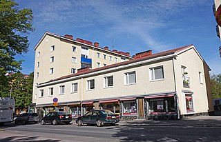
Osmonmäki is a district in the center of Tampere, Finland. The immediate neighbors of the area are Tammela, Tampella, Lappi and Petsamo. There are apartment buildings in the area, but also hundred-year-old wooden buildings. In 2011, the district had 1,613 inhabitants.

Itsenäisyydenkatu is an east–west street in the center of Tampere, Finland. It is a significant street connection in the city center of Tampere in terms of transport connections, as it leads from Tampere's railway station to the Liisankallio district in the Tammela district. On the west side of the station, the street continues as the Hämeenkatu street, at its eastern end it meets Kalevan puistokatu, branching into Teiskontie and Sammonkatu. Today, the only crossroads on Itsenäisyydenkatu with cross-street vehicle traffic is Tammelan puistokatu–Yliopistonkatu.
Lappi is a district in Tampere, Finland, near the Lake Näsijärvi and the Kauppi's park area. About 700 people live there. When talking about Lappi, reference is usually made to the Lapinniemi district. The district is home to the Koukkuniemi's nursing home, which is one of the largest nursing homes in Europe. There are also yacht clubs in the area and a spa and apartments in an old factory building were completed for the 1990 housing fair.

Tammelantori is a market square in the Tammela district in the center of Tampere in Pirkanmaa, Finland. It is one of Tampere's most significant marketplaces, which is very popular, especially during the summer. The market is very famous for its cafes and mustamakkara kiosks.

Hakametsä is a smaller district of Tampere, Finland, located about four kilometers from its city center. The neighboring parts of Hakametsä are Huikas, Ristinarkku, Messukylä, Vuohenoja, Kalevanrinne, Kaleva, Kissanmaa and Uusikylä.

Aakkula is a smaller district in Tampere, Finland, located about four kilometers from its city center. Aakkula is bordered on the west by Vuohenoja, on the east by Viiala, on the south by Turtola and on the north by Messukylä. In 2012, Aakkula had 465 inhabitants.

Tuomiokirkonkatu is a north–south street in the center of Tampere, Finland, which runs through the districts of Jussinkylä and Kyttälä. The street is about a kilometer long. In the north it ends at Lapintie, in the south Vuolteenkatu. In Kyttälä, part of Tuomiokirkonkatu has been turned into a pedestrian street. In the future, the pedestrian section will be expanded so that it will eventually extend south from Kyttälänkatu to Suvantokatu and the Sori Square.
The Sori Square is a square located in the center of Tampere, Finland, in the southern part of the Kyttälä district. It is located in the area bounded by the Hatanpää Highway, Suvantokatu, Tuomiokirkonkatu and Vuolteenkatu. At the eastern end of the square is the Tampere Orthodox Church from 1898. There is a terminus at Tampere Tram Line 1 on the west side.

Satakunnankatu is an east–west, busy street in the center of Tampere, Finland, which is one of the city's main streets. It starts from the vicinity of Tampere Cathedral on the east side of Tammerkoski, where it separates the Jussinkylä and Kyttälä Districts. The street crosses the rapids along the Satakunta Bridge (Satakunnansilta) and runs on the west side between Finlayson and the Hämeenpuisto park. From there it continues through the Amuri area to the Pirkankatu street.

Lapinniemi is a district in the northern part of Tampere, Finland. It is located on a peninsula formed on the shores of Lake Näsijärvi. Neighboring parts of the city are Petsamo, Lappi and Tampella. It is about a kilometer from the city center of Tampere to Lapinniemi, but it takes about five minutes by bus through Tammela and 10 minutes to the Central Square.

Hankkio is a district in Tampere, Finland, located in the eastern part of the city. The neighboring parts of the city are Messukylä, Ristinarkku, Linnainmaa, Vehmainen, Haihara, Kaukajärvi and Viiala. The Hankkio district is bordered on the south by the Kangasalantie road and on the north by the Tampere–Haapamäki railway.

Paasikiven–Kekkosentie, or Rantaväylä, is a busy car traffic route located in Tampere, Finland, which serves as a regional transit road and a significant access route to the city center. It is a four-lane highway owned by the Finnish state and part of Highway 12. Paasikiven–Kekkosentie is located between the Nokia's motorway and the Teiskontie street junction.

The Tampere Police Station is a police station located in the Ratina district in Tampere, Finland, and also the administrative center of the Central Finland Police Department. The police station is also used by the Finnish Security Intelligence Service (SUPO). There are about 400 police officers working there and about 50 others. The police station consists of two buildings located near the Tampere Bus Station along the Hatanpää Highway and Sorinkatu streets; due to this, in Tampere colloquially, the police station and its surroundings are also known as Sori by locals.

Tohloppi is a district of Tampere, Finland. It is located in western part of Tampere, about seven kilometers from the city center near the Tesomajärvi district. The other neighboring parts of the district also are Ikuri, Lamminpää, Epilänharju and Ristimäki. There is also a lake by the same name in the district with one island called the Tohloppi Island (Tohlopinsaari).

Sorsapuisto is a recreational area of 4.2 hectares in Tulli, Tampere, Finland, completed in the 1930s. In 1990 the Tampere Hall was built in the south corner of the park and the whole park was renovated. From 1964 to 1972 the site of the Tampere Hall hosted the Tampere zoo featuring the lions Tam and Pere.

