
Tampere is a city in Pirkanmaa in the western part of Finland. Tampere is the most populous inland city in the Nordic countries; it has a population of 238,140 with the urban area holding 334,112 people and the metropolitan area, also known as the Tampere sub-region, holding 385,301 inhabitants in an area of 4,970 km2 (1,920 sq mi). Tampere is the second-largest urban area and third most-populous individual municipality in Finland, after the cities of Helsinki and Espoo and the most populous Finnish city outside the Greater Helsinki area, within which both Helsinki and Espoo are located. Today, Tampere is one of the major urban, economic, and cultural hubs in the whole inland region.
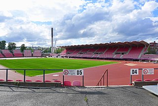
Tampere Stadium, also known as Ratina Stadium, designed by architect Timo Penttilä and completed in 1965, is a multi-purpose stadium in Tampere, Finland, with a seating capacity of 16,800 people, and up to 32,000 people for concerts. In 2018, the stadium hosted the IAAF World U20 Championships.
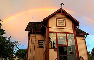
Hirvitalo is a social center in the Pispala's Tahmela district of Tampere, Finland. It houses the Center of Contemporary Art Pispala.

Kyttälä is a district in Tampere, Finland. It was born in the late 1870s as a working-class neighborhood to the eastern outskirts of the town. As Tampere soon expanded, Kyttälä is now a part of the city center between the Tammerkoski river and the railway. Population of Kyttälä is 3,348. Aleksanterinkatu is one of Kyttälä's main streets. The direct connection to the Liisankallio district and from there to Teiskontie and Sammonkatu streets runs along Itsenäisyydenkatu.
Hallituskatu is an east–west street running through the districts of Nalkala and Kaakinmaa, in the centre of Tampere, Finland. Its end point in the east is the cartboard factory area of Metsä Board Tako.
Teiskontie is a street and highway in Tampere, Finland. As its name implies, it runs from the center of Tampere towards Teisko, a former municipality connected to Tampere in 1972. To the east of the highway junction of Hervanta, it is part of Highway 12 leading in the direction of Lahti and Kouvola. On the east side of Lake Alasjärvi, Teiskontie has a connection to Highway 9 (E63) leading in the direction of Jyväskylä and Kuopio.
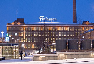
Finlayson is a neighbourhood in the city center of Tampere, Finland, and as the name implies, it consists of the old factory area of Finlayson, as well as Näsinpuisto, the Mustanlahti harbor area and the residential blocks delimited by Hämeenpuisto and Satakunnankatu. To the east, the area borders Tammerkoski. Area attractions include Tallipiha and Finlayson Church. There are also three palace buildings in the district: Finlayson Palace, Näsilinna and Little Palace (Pikkupalatsi). The area starts at Näsilinnankatu and Kuninkaankatu, which extend to Nalkala, and Puuvillatehtaankatu and Näsijärvenkatu, which cross Hämeenpuisto. Neighboring parts of the city are Tammerkoski in the south and Amuri in the west.

Särkänniemi is a district of the city centre of Tampere, Finland, located on the shores of Lake Näsijärvi, north of the districts of Amuri and Finlayson. The most famous sights of the district are Näsinneula and Särkänniemi Amusement Park, but in addition to that, the district also houses the Haarla's old paper mill building. The Amuri railway stop has also ceased operations in Särkänniemi. The Särkänniemi district also includes the Siilinkari islet in Lake Näsijärvi. Särkänniemi is bordered on the south by Paasikivenkatu, on the other side of which is the Amuri district, and on the west by the Santalahti district. The district includes the Onkiniemi residential area.

Santalahti is a district in the western part of Tampere, Finland. It borders Lake Näsijärvi in the north, the Särkänniemi district in the east, Ylä-Pispala and Ala-Pispala in the south and Lielahti in the west. The town plan of Santalahti was confirmed in 1945.

Tampere Market Hall is one of the significant market places in Tampere, Finland. It is located in the center of city, between Hämeenkatu and Hallituskatu, and it was opened in 1901. It was decided to build the market in Tampere as a result of a large and unregulated market. It is the largest market hall in the Nordic countries.

Keskusta ("Center") is a main district of the city of Tampere, Finland, formed by less than 20 suburbs in the city centre. Over 63,000 people live in Keskusta. It is located along the Tammerkoski rapids and its most important services include Tampere City Hall and the Market Hall.

Itsenäisyydenkatu is an east-west street in the center of Tampere, Finland. It is a significant street connection in the city center of Tampere in terms of transport connections, as it leads from Tampere's railway station to the Liisankallio district in the Tammela district. On the west side of the station, the street continues as the Hämeenkatu street, at its eastern end it meets Kalevan puistokatu, branching into Teiskontie and Sammonkatu. Today, the only crossroads on Itsenäisyydenkatu with cross-street vehicle traffic is Tammelan puistokatu–Yliopistonkatu.

Tammelantori is a market square in the Tammela district in the center of Tampere in Pirkanmaa, Finland. It is one of Tampere's most significant marketplaces, which is very popular, especially during the summer. The market is very famous for its cafes and mustamakkara kiosks.
Hatanpää is a district in Tampere, Finland, located in the southern part of the city center on the shores of Lake Pyhäjärvi. Hatanpää is actually a peninsula that protrudes towards the lake, leaving the waters of Viinikanlahti Bay to the north and Vihilahti Bay to the south. The area is named after Hatanpää Manor, whose land from Härmälä to Sääksjärvi and Nekala was bought for the city in 1913. Administratively, the area has belonged to the city since 1920. In 2014, the population of the area was measured as 2,686 inhabitants.

Näsilinna is a neo-baroque palace on Näsikallio in Tampere, Finland. It was built by Peter von Nottbeck, son of Wilhelm von Nottbeck, a St. Petersburg-based industrial manager of Finlayson. The original name of the palace, completed in 1898, was Milavida. The building was designed by architect K. A. Wrede. The true meaning and history of the name Milavida is unknown.

Multisilta is the southern suburb of Tampere, Finland, about eight kilometers from the its city center. Multisilta was built from the late 1960s to the 1990s. The district has a population of about 3,000. In the center there is a pub, a grocery store, a youth center and a kebab pizzeria grill. There is a water tower to the north of the residential area. Multisilta borders the Peltolammi district in the north and the Vuores district in the east. In the south you will meet the Lempäälä border and in the west the Pirkkala border. To the east, the district is bordered by the end of Vuoreksenkatu and the Highway 3 (E12). Multisilta can be reached by public transport buses 26, 35 and 50 in the Tampere region.

Tahmela is a district in Tampere, Finland. It is located between Ylä-Pispala and Pyynikki on the shores of Lake Pyhäjärvi. There is a Varala Sports College in Tahmela. There are rental agricultural plots on the shore of Tahmela, and Kurpitsaliike ry was founded in 1998 to defend the continuation of land cultivation in Tahmela.

Lentävänniemi is a district in the western part of Tampere on the shores of Lake Näsijärvi in Pirkanmaa, Finland. It belongs to the northwestern part of the city and borders the Niemi and Niemenranta borders on the southwest. There are jogging paths along the lake and its shores surrounding the apartment-based Lentävänniemi. In 2014, the population of Lentävänniemi was 4,309.

Ratina is a shopping center in Finland, opened in the heart of Tampere on 19 April 2018, construction of which began in April 2015. Ratina is Tampere's largest shopping center with 53,000 square meters of retail space, offering groceries, fashion, interior design, wellness and leisure services, as well as cafés and restaurants. Under it, a parking space for more than 1,200 cars has been built, which is the largest parking garage in the center of Tampere. The Ratina shopping center is built between Ratina Stadium and the Tampere Bus Station, and there is also an underground connection to the bus station below the Vuolteenkatu street. The new building in the shopping center is largely located on the former pier area of the bus station. The shopping center is also accessible directly from the bus station via escalators. The developer is Sponda, which was selected as the contractor by the City Board in April 2006. The consortium of Citycon Oyj and Skanska, YIT and NCC also submitted their bids.

Laukontori is a market square in the southern part of the city center of Tampere, Finland, on the shores of Lake Pyhäjärvi. It is located just a few hundred meters from Tampere Central Square. Square's beach serves as a harbor for cruise ships to the Viikinsaari island and the city of Hämeenlinna in the summer.


