South Bank, Queensland

Last updated

View of part of South Bank from the City. South Bank inna Brisbane.jpg
View of part of South Bank from the City.

South Bank is a cultural, social, educational and recreational precinct in Brisbane, Queensland, Australia. The precinct is located in the suburb of South Brisbane, on the southern bank of the Brisbane River.

Contents

History

The South Bank area was a central point for immigration in Brisbane in the 1840s and by the 1850s had become the city's main business district. After the 1893 flood, the central business district was moved to the north side of the river. By the 1930s the area was a busy industrial area and port. [1] [2]

World Expo 88 and Parklands opening

In 1984 South Bank was chosen for World Expo 88, the event lasted from 30 April to 30 October 1988 and brought in 18 million visitors during its run. After Expo 88 the land where it was held was cleared and was originally going to be sold but public lobbying caused the site to be turned into public park instead. On 20 June 1992 the South Bank Parklands were opened to the public. [3] [2] [1]

On 31 August 2008 the Wheel Of Brisbane, a 60 metre tall Ferris wheel was installed in the parklands. The wheel was installed to commemorate the 20th anniversary of Expo 88. The wheel was damaged in 2011 during a river flood. [3]

Landmarks

South Bank Parklands

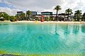
The South Bank Parklands, which were established on the former site of World Expo 88, are one of Brisbane's most popular tourist attractions. The parklands are home to many restaurants and cafés as well as landmarks such as the Queensland Conservatorium, the Wheel of Brisbane, the Nepalese Peace Pagoda, Streets Beach (a free human-made swimming area), and the Grand Arbour. Approximately 11,000,000 people visit the South Bank Parklands each year. [4]

Grey Street & Little Stanley Street

A number of Brisbane's most popular restaurants and fashion boutiques are located on Grey Street, and Little Stanley Street which it runs parallel to. [5] [6] The South Bank Cinemas are also located on Grey Street, along with two five star hotels. [7]

Brisbane Convention and Exhibition Centre

The Brisbane Convention & Exhibition Centre contains 44 meeting and event spaces, including four exhibition halls with a combined area of 20,000 m² and three stand alone tiered auditora. [8] The venue has received 126 major industry awards, making it the most awarded convention centre in Australia. [9] The centre has also been ranked among the top three convention centres world-wide by the Association Internationale des Palais de Congres (AIPC) on three separate occasions. [10] The centre was also host to the G20 Leaders Summit in November 2014.

Queensland Maritime Museum

The Queensland Maritime Museum is located next to the Goodwill Bridge at the southern end of the South Bank Parklands. It houses a two level exhibition building, a library, a dry dock, a lighthouse and several retired vessels.

Queensland Cultural Centre

The Queensland Cultural Centre consists of:

Griffith University

Griffith University has three campus facilities present in South Bank: [11] [12]

Transport

South Bank is serviced by Translink with ferry, bus and rail transit in the area. [13] [14]

Related Research Articles

<span class="mw-page-title-main">Brisbane</span> City of Queensland, Australia

Brisbane is the capital and most populous city of Queensland and the third-most populous city in Australia and Oceania, with a population of approximately 2.6 million. Brisbane lies at the centre of South East Queensland, which includes several other regional centres and cities. The central business district is situated within a peninsula of the Brisbane River about 15 km (9 mi) from its mouth at Moreton Bay. Brisbane is located in the hilly floodplain of the Brisbane River Valley between Moreton Bay and the Taylor and D'Aguilar mountain ranges. It sprawls across several local government areas, most centrally the City of Brisbane. The demonym of Brisbane is Brisbanite.

<span class="mw-page-title-main">World Expo 88</span> Worlds fair held in Brisbane, Australia in 1988

World Expo 88, also known as Expo 88, was a specialised Expo held in Brisbane, the state capital of Queensland, Australia, during a six-month period between Saturday, 30 April 1988 and Sunday, 30 October 1988, inclusive. The theme of the Expo was "Leisure in the Age of Technology", and the mascot for the Expo was an Australian platypus named Expo Oz.

<span class="mw-page-title-main">Roma Street railway station</span> Railway station in Brisbane, Queensland

Roma Street railway station is located in the Brisbane central business district, Queensland, Australia. It is the junction station for the North Coast, Main, Gold Coast and NSW North Coast lines. The station is one of four inner city stations that form a core corridor through the centre of Brisbane.

<span class="mw-page-title-main">South Brisbane railway station</span> Historic site in Queensland, Australia

South Brisbane railway station is a heritage-listed railway station at 133 Grey Street, South Brisbane, City of Brisbane, Queensland, Australia. It is one of two stations serving the South Brisbane area, the other being South Bank. It was built from 1891 to 1918, making it the second oldest railway station in central Brisbane. It is also known as Cultural Centre Station, Melbourne Street Station, and South Brisbane (Interstate) Station. It was added to the Queensland Heritage Register on 21 October 1992.

<span class="mw-page-title-main">South Bank railway station, Brisbane</span> Railway station in Brisbane, Queensland, Australia

South Bank railway station is located on the Gold Coast line in Brisbane, Queensland, Australia. It is one of two stations serving the South Brisbane area, the other being South Brisbane station. It was formerly known as Vulture Street station due to being located on Vulture Street.

<span class="mw-page-title-main">South Bank Parklands</span> Brisbane parkland

The South Bank Parklands are located at South Bank within the suburb of South Brisbane in Brisbane, Queensland, Australia. The parkland, on the transformed site of Brisbane's World Expo 88, was officially opened to the public on 20 June 1992.

<span class="mw-page-title-main">South Brisbane, Queensland</span> Suburb of Brisbane, Queensland, Australia

South Brisbane is an inner southern suburb in the City of Brisbane, Queensland, Australia. In the 2016 census, South Brisbane had a population of 7,196 people.

<span class="mw-page-title-main">South East Busway</span> Bus-only road in Queensland, Australia

The South East Busway is a grade separated bus-only road running south from the Brisbane central business district to Eight Mile Plains in Queensland, Australia. The busway was completed to Woolloongabba in September 2000 and to Eight Mile Plains in April 2001. An extension of the busway to School Road at Rochedale was completed in 2014 with no additional busway stations. The maximum capacity of the busway is 18,000 commuters an hour during peak periods. The busway carries an estimated 70 million passengers annually.

<span class="mw-page-title-main">Brisbane Convention & Exhibition Centre</span> Convention center in Brisbane, Australia

Brisbane Convention & Exhibition Centre (BCEC) is a convention centre in Brisbane, Australia. It is located in South Brisbane and occupies most of the block formed by Grey Street, Melbourne Street, Merivale Street, and Glenelg Street. The centre is owned by South Bank Corporation and managed by ASM Global.

<span class="mw-page-title-main">Queensland Cultural Centre</span> Historic site in Queensland, Australia

The Queensland Cultural Centre is a heritage-listed cultural center on Grey Street, South Brisbane, Queensland, Australia. It is part of the South Bank precinct on the Brisbane River and was built from 1976.

<span class="mw-page-title-main">Queen Street bus station</span> Bus station in Brisbane, Queensland

Queen Street bus station is the primary bus terminus in Brisbane central business district in Queensland, Australia. It is underneath Uptown, Brisbane & Queen Street Mall. It opened on 26 March 1988 along with the Myer Centre. At the time it was the largest underground diesel bus station in the world.

<span class="mw-page-title-main">Cultural Centre busway station</span> Bus station in Brisbane, Australia

Cultural Centre busway station is located in Brisbane, Australia serving the South Bank precinct. It is located directly south of Victoria Bridge and close to South Brisbane railway station.

<span class="mw-page-title-main">Culture of Brisbane</span> Overview of the culture of Brisbane (Australia)

The culture of Brisbane derives from Australian culture and incorporates a strong history in the performing arts, music and sport.

<span class="mw-page-title-main">Griffith University busway station</span> Bus station in Brisbane, Australia

Griffith University busway station is located in Brisbane, Australia serving the Griffith University, Mount Gravatt and Nathan campuses. It opened on 30 April 2001 when the South East Busway was extended from Woolloongabba to Eight Mile Plains.

<span class="mw-page-title-main">Brisbane central business district</span> Suburb of Brisbane, Queensland, Australia

Brisbane City is the central suburb and central business district of Brisbane, the state capital of Queensland, Australia. It is colloquially referred to as the "Brisbane CBD" or "the city". It is located on a point on the northern bank of the Brisbane River, historically known as Meanjin, Mianjin or Meeanjin in the local Aboriginal Australian dialect. The triangular shaped area is bounded by the median of the Brisbane River to the east, south and west. The point, known at its tip as Gardens Point, slopes upward to the north-west where the city is bounded by parkland and the inner city suburb of Spring Hill to the north. The CBD is bounded to the north-east by the suburb of Fortitude Valley. To the west the CBD is bounded by Petrie Terrace, which in 2010 was reinstated as a suburb.

<span class="mw-page-title-main">Bretts Wharf</span>

Bretts Wharf is a ferry terminal on the northern bank of the Brisbane River in the suburb of Hamilton in the City of Brisbane, Queensland, Australia. It serves patrons from nearby Racecourse Road and Portside Wharf, as well as visitors to Eagle Farm Racecourse and Doomben Racecourse in the Brisbane suburbs of Hamilton and Ascot. Bretts Wharf was the terminus for downstream CityCat services until Apollo Road reopened in February 2008. It is served by RiverCity Ferries' CityCat services.

<span class="mw-page-title-main">South Bank ferry wharf</span> CityCat wharves in Brisbane, Australia

South Bank ferry wharf is located on the southern side of the Brisbane River serving the Brisbane suburb of South Brisbane in Queensland, Australia. The wharf is used by RiverCity Ferries CityCat and CityHopper services.

<span class="mw-page-title-main">Transport in Brisbane</span>

Transport in Brisbane, the capital and largest city of Queensland, Australia, is provided by road, rail, river and bay ferries, footpaths, bike paths, sea and air.

Stanley Street is a major street in Brisbane, Queensland. It carries the designation state route 41 for the entirety of its length and state route 10 between the Vulture Street and Annerley Road intersections. For the majority of its length the road is a one-way carriageway westbound. The route is a major connector between the Southern and Eastern suburbs and South Brisbane. The street passes directly to the south of The Gabba and runs directly through the Mater Hospital precinct.

<span class="mw-page-title-main">Tourism in Brisbane</span>

Tourism in Brisbane is an important industry for the Queensland economy, being the third-most popular destination for international tourists after Sydney and Melbourne.

References

  1. 1 2 "Our history | Future South Bank". yoursay.futuresouthbank.com.au. Retrieved 1 October 2023.
  2. 1 2 "History of South Bank | Visit Brisbane,Brisbane". visit.brisbane.qld.au. Retrieved 1 October 2023.
  3. 1 2 "Opening of the South Bank Parklands (1992)". State Library Of Queensland. 20 June 2012. Retrieved 1 October 2023.
  4. South Bank information Archived 2010-02-20 at the Wayback Machine
  5. Grey Street Boulevard
  6. Little Stanley Street
  7. Grey Street Shopping centre Archived 2010-01-28 at the Wayback Machine
  8. "Home". bcec.com.au.
  9. Brisbane Convention & Exhibition Centre (index page)
  10. Brisbane Convention & Exhibition Centre
  11. "South Bank campus". www.griffith.edu.au. Retrieved 3 November 2023.
  12. https://www.griffith.edu.au/__data/assets/pdf_file/0023/361670/South-Bank-campus-map.pdf
  13. "220531-train-busway-tram-network-map.pdf". translink.widen.net. Retrieved 30 September 2023.
  14. "230109-brisbane-ferry-fare-zone.pdf". translink.widen.net. Retrieved 30 September 2023.

27°28′31″S153°01′13″E / 27.47528°S 153.02028°E / -27.47528; 153.02028