South Carolina Highway 253

Last updated

South Carolina 253.svg

South Carolina Highway 253
SC 253 map.svg
Route information
Maintained by SCDOT
Length19.4 mi [1] (31.2 km)
Existed1939–present
Major junctions
South endSouth Carolina 124.svg SC 124 in Parker
 
North endSouth Carolina 414.svg SC 414 in Tigerville
Location
Counties Greenville
Highway system
South Carolina 252.svg SC 252 SC 254 South Carolina 254.svg

South Carolina Highway 253 (SC 253) is a primary state highway in the U.S. state of South Carolina. It runs in Greenville and is the gateway to Paris Mountain State Park and runs from Parker to Tigerville.

A state highway, state road, or state route is usually a road that is either numbered or maintained by a sub-national state or province. A road numbered by a state or province falls below numbered national highways in the hierarchy. Roads maintained by a state or province include both nationally numbered highways and un-numbered state highways. Depending on the state, "state highway" may be used for one meaning and "state road" or "state route" for the other.

U.S. state constituent political entity of the United States

In the United States, a state is a constituent political entity, of which there are currently 50. Bound together in a political union, each state holds governmental jurisdiction over a separate and defined geographic territory and shares its sovereignty with the federal government. Due to this shared sovereignty, Americans are citizens both of the federal republic and of the state in which they reside. State citizenship and residency are flexible, and no government approval is required to move between states, except for persons restricted by certain types of court orders. Four states use the term commonwealth rather than state in their full official names.

South Carolina State of the United States of America

South Carolina is a state in the Southeastern United States and the easternmost of the Deep South. It is bordered to the north by North Carolina, to the southeast by the Atlantic Ocean, and to the southwest by Georgia across the Savannah River.

Contents

Route description

The highway begins at SC 124 near Parker and travels 12 mi (0.80 km) northeast to SC 183 as West Blue Ridge Drive. It then moves up to Sulphur Springs Road where the road changes to East Blue Ridge Drive before intersecting at Poinsett Highway on U.S. Highway 276 (US 276) before running concurrently on SC 291 as North Pleasantburg Drive for 0.16 mi (0.26 km) before turning left at Paris Mountain Road. After traveling 2.53 mi (4.07 km) and passing Greenvista Drive, SC 253 becomes East Mountain Creek Road and traveling and additional 6.71 mi (10.80 km) before intersecting with SC 290. SC 253 then turns left and goes 7.22 mi (11.62 km) before terminating at SC 414 in Tigerville. [1] [2]

South Carolina Highway 124

South Carolina Highway 124 (SC 124) is a 5.63-mile-long (9.06 km) state highway in the U.S. state of South Carolina. The highway connects Parker and Greenville.

South Carolina Highway 183 highway in South Carolina

South Carolina Highway 183 is a South Carolina State Highway that runs from Westminster to Greenville.

South Carolina Highway 291 highway in South Carolina

South Carolina Highway 291, locally known as Pleasantburg Drive, is a South Carolina state highway that runs as a major commercial artery for the eastern sections of Greenville, South Carolina in Greenville County, South Carolina. This highway runs by Greenville Technical College, the Greenville Downtown Airport, and Bob Jones University. The road south of U.S. Highway 276 (US 276), Laurens Road, is called South Pleasantburg Drive, while the road north of Laurens Road is called North Pleasantburg Drive.

History

SC 253 started in 1939 at the intersection of US 25 and US 276 to form an 11 mi (18 km) highway around Paris Mountain State Park, ending around Travelers Rest. Nine years later, SC 253 was reduced to secondary status with part of the road becoming county roads S-23-22. The road was resurrected in 1950 as a north-south road to Tigerville. In 1965, SC 253 was extended to SC 250 which is now part of US 25 and then extended southwest again between 1968 and 1970 to its current terminus at SC 124.

U.S. Route 25 in South Carolina highway in South Carolina

U.S. Route 25 (US 25) is a U.S. Highway that travels from Brunswick, Georgia to the Kentucky-Ohio state line, where Covington, Kentucky meets Cincinnati, Ohio at the Ohio River. In the U.S. state of South Carolina, it begins as a 140.4-mile-long (226.0 km) highway that travels south to north in the western part of the state, serving the northern part of the Augusta metropolitan area, Greenwood, and Greenville on its path from North Augusta to North Carolina in the Saluda Mountains, near Travelers Rest.

Travelers Rest, South Carolina City in South Carolina, United States

Travelers Rest is a city in Greenville County, South Carolina, United States. The population was 4,576 at the 2010 census, up from 4,099 in 2000. The population was an estimated 4,994 in 2015. It is part of the Greenville–Mauldin–Easley Metropolitan Statistical Area. Travelers Rest is located between the Blue Ridge Mountains and Greenville, the primary city of the Upstate region of South Carolina. The campus of Furman University is located just south of the city limits of Travelers Rest, but the university retains a Greenville address based on its ZIP code.

Improvements to the road include the road being fully paved in 1941 or 1942, being four-laned with SC 291 between 1968 and 1970, and four-laned again for a distance south of US 276 in 1977.

Major intersections

The entire route is in Greenville County.

Locationmi [1] kmDestinationsNotes
Parker 0.00.0South Carolina 124.svg SC 124 (Old Easley Highway) Greenville, Easley
0.50.80US 25.svgI-85.svg US 25 (White Horse Road) to I-85  Greenwood, Travelers Rest
2.33.7South Carolina 183.svg SC 183 (Cedar Lane Road) Greenville, Pickens
Sans Souci 4.57.2US 276.svg US 276 (Poinsett Highway) Greenville, Travelers Rest
4.77.6South Carolina 291.svg SC 291 east (Pleasantburg Drive) Wade Hampton
13.621.9South Carolina 290.svg SC 290 east (Locust Hill Road) Greer South end of concurrency with SC 290
13.822.2South Carolina 290.svg SC 290 west (Locust Hill Road) Slater-Marietta North end of concurrency with SC 290
Tigerville 19.431.2South Carolina 414.svg SC 414  Campobello, Slater-Marietta
1.000 mi = 1.609 km; 1.000 km = 0.621 mi

Related Research Articles

U.S. Route 123 is a spur of US 23 in the U.S. states of Georgia and South Carolina. The U.S. Highway runs 75.12 miles (120.89 km) from US 23, US 441, and SR 365 near Clarkesville, Georgia, north and east to Interstate 385 Business in Greenville, South Carolina. US 123 parallels I-85 to the north as it connects the Northeast Georgia cities of Clarkesville and Toccoa with the western Upstate South Carolina communities of Westminster, Seneca, Clemson, Easley, and Greenville.

U.S. Route 176 highway in the United States

U.S. Route 176 is a spur of US 76 in the U.S. states of North Carolina and South Carolina. The U.S. Highway runs 237.98 miles (382.99 km) from US 25 Business and North Carolina Highway 225 in Hendersonville, North Carolina, east to US 52 in Goose Creek, South Carolina. US 176 serves the transition region between the Blue Ridge Mountains and Foothills of Western North Carolina and the Upstate, Midlands, and Lowcountry regions of South Carolina. The highway passes through and connects Spartanburg, one of two major cities in the Upstate, and Columbia, the South Carolina state capital and central city of the Midlands. US 176 parallels and serves as a secondary highway to Interstate 26 (I-26) except for between Spartanburg and Columbia, where the U.S. Highway deviates from the I-26 corridor to serve Union.

U.S. Route 178 highway in the United States

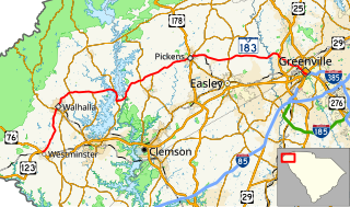
U.S. Highway 178 is a spur of U.S. Highway 78. It currently runs for 240.49 miles (387.03 km) from Dorchester, South Carolina, at U.S. Highway 78 to Rosman, North Carolina, at U.S. Highway 64. It passes through the states of South Carolina and North Carolina. It goes through the cities of Pickens, Anderson, North crossing the highway 321, Orangeburg, Harleyville, South Carolina and Bowman, South Carolina.

U.S. Route 276 is a United States highway that runs for 106.4 miles (171.2 km) from Mauldin, South Carolina to Cove Creek, North Carolina. It is known both as a busy urban highway in Greenville, South Carolina and a scenic back-road in Western North Carolina.

South Carolina Highway 93 highway in South Carolina

South Carolina Highway 93 is a primary state highway in the U.S. state of South Carolina. It runs from U.S. Route 76 (US 76) and SC 28 in Clemson northeast to US 123 in Easley.

South Carolina Highway 8 highway in South Carolina

South Carolina Highway 8 is a primary state highway in the U.S. state of South Carolina. It runs from U.S. Route 276 (US 276) in northern Greenville County to US 25 and SC 418 in Ware Place. It runs physically north and south though it is signed as a west-east highway with its western terminus at US 276 and its eastern terminus at US 25/SC 418.

U.S. Route 29 in South Carolina highway in South Carolina

U.S. Route 29 is a north–south United States highway that runs for 109.1 miles (175.6 km) from the Savannah River to Blacksburg, entirely in Upstate South Carolina.

South Carolina Highway 14 highway in South Carolina

South Carolina Highway 14 is a state highway in the U.S. state of South Carolina. The state highway runs 59.24 miles (95.34 km) from U.S. Route 76 Business in Laurens north to Interstate 26 (I-26) in Landrum. SC 14 connects Laurens and Landrum with Greer, the city between Greenville and Spartanburg where the highway crosses I-85 and US 29. The highway also parallels I-385 through Fountain Inn and Simpsonville, South Carolina in southeastern Greenville County. SC 14 is a part of the National Highway System between I-85 and US 29 in Greer.

South Carolina Highway 101 highway in South Carolina

South Carolina Highway 101 is a state route in Laurens, Spartanburg, and Greenville counties. Its southern terminus is at a junction with U.S. Route 76 in Hickory Tavern, and its northern terminus is at a junction with SC 11 near Landrum.

South Carolina Highway 290 is a state highway in South Carolina, United States, that courses through central Greenville and Spartanburg Counties.

South Carolina Highway 86

South Carolina Highway 86 (SC 86) is a 11.9-mile-long (19.2 km) state highway in the U.S. state of South Carolina. The highway connects the Easley and Piedmont areas.

South Carolina Highway 185

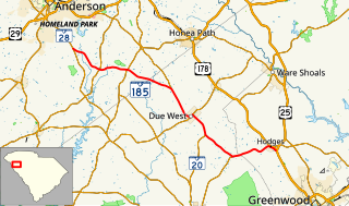
South Carolina Highway 185 (SC 185) is a 26.7-mile-long (43.0 km) state highway in the U.S. state of South Carolina. The highway connects Hodges and Due West with the Homeland Park area.

South Carolina Highway 254

South Carolina Highway 254 (SC 254) is a 8.2-mile-long (13.2 km) state highway in the U.S. state of South Carolina. The highway connects Greenwood and Cokesbury.

South Carolina Highway 267 (SC 267) is a 23.4-mile-long (37.7 km) state highway in the U.S. state of South Carolina. The highway connects the Santee area with rural areas of Orangeburg and Calhoun counties, via Elloree.

South Carolina Highway 288 (SC 288) is a 15.3-mile-long (24.6 km) state highway in the U.S. state of South Carolina. The highway connects Pumpkintown and Slater-Marietta.

South Carolina Highway 414 (SC 414) is a 17-mile-long (27 km) state highway in the U.S. state of South Carolina. The highway travels through mostly rural areas of Greenville County.

References

  1. 1 2 3 Google (2014-01-21). "South Carolina Highway 253" (Map). Google Maps . Google. Retrieved 2014-01-21.
  2. "General County Highway Maps". South Carolina Department of Transportation. Retrieved 2014-01-21.
KML file (edithelp)
    KML is not from Wikidata