Campobello, South Carolina

Last updated

Campobello, South Carolina
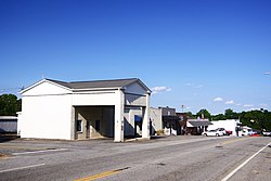
Campobello-Main-St-sc.jpg
Main Street (US 176)
SCMap-doton-Campobello.PNG
Location of Campobello, South Carolina
Coordinates: 35°6′55″N82°8′59″W / 35.11528°N 82.14972°W / 35.11528; -82.14972
Country United States
State South Carolina
County Spartanburg
Area
[1]
  Total2.78 sq mi (7.21 km2)
  Land2.78 sq mi (7.21 km2)
  Water0.00 sq mi (0.00 km2)
Elevation
922 ft (281 m)
Population
 (2020) [2]
  Total675
  Density242.63/sq mi (93.68/km2)
Time zone UTC-5 (Eastern (EST))
  Summer (DST) UTC-4 (EDT)
ZIP code
29322
Area code 864
FIPS code 45-11125 [3]
GNIS feature ID1247131 [4]
Website Town website

Campobello is a town in Spartanburg County, South Carolina, United States, along the South Pacolet River. The population was 502 at the 2010 census. [5]

Contents

History

Campobello was founded in 1840. [6] Campobello is a name derived from Italian meaning "beautiful field". [7] A post office called Campobello has been in operation since 1850. [8]

Geography

Campobello is located at 35°6′55″N82°8′59″W / 35.11528°N 82.14972°W / 35.11528; -82.14972 (35.115403, -82.149622). [9] The town is concentrated around the intersection of U.S. Route 176 and South Carolina Highway 357, northwest of Spartanburg, and a few miles south of the North Carolina-South Carolina border. South Carolina Highway 11 passes through the northern part of Campobello, connecting the town with Interstate 26 to the east.

According to the United States Census Bureau, the town has a total area of 0.9 square miles (2.3 km2), all land.

Demographics

Historical population
CensusPop.Note
1880 99
1890 13738.4%
1900 20348.2%
1910 25525.6%
1920 30921.2%
1930 34010.0%
1940 38914.4%
1950 3941.3%
1960 4206.6%
1970 53026.2%
1980 472−10.9%
1990 465−1.5%
2000 449−3.4%
2010 50211.8%
2020 67534.5%
U.S. Decennial Census [10] [2]

2020 census

Campobello racial composition [11]
RaceNum.Perc.
White (non-Hispanic)56183.11%
Black or African American (non-Hispanic)253.7%
Native American 10.15%
Asian 162.37%
Other/Mixed 375.48%
Hispanic or Latino 355.19%

As of the 2020 United States census, there were 675 people, 208 households, and 145 families residing in the town.

2000 census

As of the census [3] of 2000, there were 449 people, 160 households, and 124 families residing in the town. The population density was 520.8 inhabitants per square mile (201.1/km2). There were 176 housing units at an average density of 204.1 per square mile (78.8/km2). The racial makeup of the town was 85.97% White, 8.69% African American, 0.45% Native American, 4.01% Asian, and 0.89% from two or more races. Hispanic or Latino of any race were 0.89% of the population.

There were 160 households, out of which 33.8% had children under the age of 18 living with them, 61.3% were married couples living together, 15.0% had a female householder with no husband present, and 22.5% were non-families. 18.8% of all households were made up of individuals, and 11.3% had someone living alone who was 65 years of age or older. The average household size was 2.76 and the average family size was 3.18.

In the town, the population was spread out, with 25.8% under the age of 18, 8.2% from 18 to 24, 25.4% from 25 to 44, 26.9% from 45 to 64, and 13.6% who were 65 years of age or older. The median age was 40 years. For every 100 females, there were 91.1 males. For every 100 females age 18 and over, there were 88.1 males.

The median income for a household in the town was $36,250, and the median income for a family was $41,250. Males had a median income of $29,500 versus $21,875 for females. The per capita income for the town was $15,904. About 3.1% of families and 5.2% of the population were below the poverty line, including 8.5% of those under age 18 and 8.1% of those age 65 or over.
Related Research Articles

<span class="mw-page-title-main">East Flat Rock, North Carolina</span> Census-designated place in North Carolina, United States

East Flat Rock is an unincorporated area and census-designated place (CDP) in Henderson County, North Carolina, United States. The population was 4,995 at the 2010 census, up from 4,151 at the 2000 census. It is part of the Asheville Metropolitan Statistical Area.

<span class="mw-page-title-main">Hays, North Carolina</span> CDP in North Carolina, United States

Hays is a census-designated place (CDP) in Wilkes County, North Carolina, United States. The population was 1,595 at the 2020 census. North Wilkes High School, one of Wilkes County's four public high schools, is located in Hays.

<span class="mw-page-title-main">Gaffney, South Carolina</span> City in South Carolina, United States

Gaffney is a city in and the seat of Cherokee County, South Carolina, United States, in the Upstate region of South Carolina. Gaffney is known as the "Peach Capital of South Carolina". The population was 12,539 at the 2010 census, with an estimated population of 12,609 in 2019. It is the principal city of the Gaffney, South Carolina, Micropolitan Statistical Area, which includes all of Cherokee County and which is further included in the greater Greenville-Spartanburg-Anderson, South Carolina Combined Statistical Area.

<span class="mw-page-title-main">Great Falls, South Carolina</span> Town in South Carolina, United States

Great Falls is a town in Chester County, South Carolina, United States and is located fourteen miles southwest of Lancaster, South Carolina. The population was 1,951 at the 2020 census.

<span class="mw-page-title-main">Parksville, South Carolina</span> Town in South Carolina, United States

Parksville is a town in McCormick County, South Carolina, United States. The population was 117 at the 2010 census.

<span class="mw-page-title-main">Plum Branch, South Carolina</span> Town in South Carolina, United States

Plum Branch is a town in McCormick County, South Carolina, United States. The population was 82 at the 2010 census.

<span class="mw-page-title-main">Boiling Springs, South Carolina</span> CDP in South Carolina, United States

Boiling Springs is a census-designated place (CDP) in Spartanburg County, South Carolina, United States. The population was 8,219 at the 2010 census.

<span class="mw-page-title-main">Cowpens, South Carolina</span> Town in South Carolina, United States

Cowpens is a town in Spartanburg County, South Carolina, United States. The population was 2,162 at the 2010 census. The town was chartered February 20, 1880, and was incorporated in 1900.

<span class="mw-page-title-main">Duncan, South Carolina</span> Town in South Carolina, United States

Duncan is a town in Spartanburg County, South Carolina, United States. Its population was 3,181 at the 2010 census.

<span class="mw-page-title-main">Inman Mills, South Carolina</span> CDP in South Carolina, United States

Inman Mills is a census-designated place (CDP) in Spartanburg County, South Carolina, United States. The population was 1,050 at the 2010 census.

<span class="mw-page-title-main">Landrum, South Carolina</span> City in South Carolina, United States

Landrum is a city in Spartanburg County, South Carolina, United States. The population was 2,376 at the 2010 census.

<span class="mw-page-title-main">Lyman, South Carolina</span> Town in South Carolina, United States

Lyman is a town in Spartanburg County, South Carolina, United States. Its population was 6,173 at the 2020 census.

<span class="mw-page-title-main">Mayo, South Carolina</span> CDP in South Carolina, United States

Mayo is a census-designated place (CDP) in Spartanburg County, South Carolina, United States. The population was 1,592 at the 2010 census.

<span class="mw-page-title-main">Reidville, South Carolina</span> Town in South Carolina, United States

Reidville is a town in Spartanburg County, South Carolina, United States. The population was 601 at the 2010 census.

<span class="mw-page-title-main">Saxon, South Carolina</span> CDP in South Carolina, United States

Saxon is a census-designated place (CDP) in Spartanburg County, South Carolina, United States. The population was 3,424 at the 2010 census.

<span class="mw-page-title-main">Startex, South Carolina</span> CDP in South Carolina, United States

Startex is a census-designated place (CDP) in Spartanburg County, South Carolina, United States. The population was 859 at the 2010 census. The area was originally known as Tucapau, named after the mill that was built there in 1896. In 1936, Walter Montgomery Sr. bought the mill and changed its name to Startex—the brand name of household textiles produced at the plant. The mill ceased operations in 1998 and was mostly dismantled in 1999.

<span class="mw-page-title-main">Valley Falls, South Carolina</span> CDP in South Carolina, United States

Valley Falls is a census-designated place (CDP) in Spartanburg County, South Carolina, United States. The population was 6,299 at the 2010 census.

<span class="mw-page-title-main">Wellford, South Carolina</span> City in South Carolina, United States

Wellford is a city in Spartanburg County, South Carolina, United States. The population was 3,293 at the 2020 census, up from 2,378 in 2010.

<span class="mw-page-title-main">Woodruff, South Carolina</span> City in South Carolina, United States

Woodruff is a city in Spartanburg County, South Carolina, United States, located in upstate South Carolina. The population was 4,333 at the 2020 census.

<span class="mw-page-title-main">Chesnee, South Carolina</span> City in South Carolina, United States

Chesnee is a city in Spartanburg and Cherokee counties, in the U.S. state of South Carolina. The population was 868 as of the 2010 census.

References

  1. "ArcGIS REST Services Directory". United States Census Bureau. Retrieved October 15, 2022.
  2. 1 2 "Census Population API". United States Census Bureau. Retrieved October 15, 2022.
  3. 1 2 "U.S. Census website". United States Census Bureau . Retrieved January 31, 2008.
  4. "US Board on Geographic Names". United States Geological Survey. October 25, 2007. Retrieved January 31, 2008.
  5. "Race, Hispanic or Latino, Age, and Housing Occupancy: 2010 Census Redistricting Data (Public Law 94-171) Summary File (QT-PL), Campobello town, South Carolina". United States Census Bureau . Retrieved August 16, 2011.
  6. Federal Writers' Project (1941). Palmetto Place Names. Sloane Printing Co. p. 31.
  7. Baker, Elaine (March 22, 1991). "Communities have colorful backgrounds". Herald-Journal. p. 8. Retrieved October 14, 2015.
  8. "Spartanburg County". Jim Forte Postal History. Retrieved October 14, 2015.
  9. "US Gazetteer files: 2010, 2000, and 1990". United States Census Bureau. February 12, 2011. Retrieved April 23, 2011.
  10. "Census of Population and Housing". Census.gov. Retrieved June 4, 2015.
  11. "Explore Census Data". data.census.gov. Retrieved December 10, 2021.