
South Carolina is a state in the coastal Southeastern region of the United States. It is bordered to the north by North Carolina, to the southeast by the Atlantic Ocean, and to the southwest by Georgia across the Savannah River. South Carolina is the 40th most extensive and 23rd most populous U.S. state with a recorded population of 5,124,712 according to the 2020 census. In 2019, its GDP was $213.45 billion. South Carolina is composed of 46 counties. The capital is Columbia with a population of 137,300 in 2020; while its largest city is Charleston with a 2020 population of 150,277. The Greenville–Spartanburg-Anderson metropolitan area is the most populous in the state, with a 2020 population estimate of 1,455,892.

Westchester County is located in the U.S. state of New York. It is the seventh most populous county in the State of New York and the most populous north of New York City. According to the 2020 United States Census, the county had a population of 1,004,456, its highest decennial count ever and an increase of 55,344 (5.8%) from the 949,113 counted in 2010. Located in the Hudson Valley, Westchester covers an area of 450 square miles (1,200 km2), consisting of six cities, 19 towns, and 23 villages. Established in 1683, Westchester was named after the city of Chester, England. The county seat is the city of White Plains, while the most populous municipality in the county is the city of Yonkers, with 211,569 residents per the 2020 U.S. Census.

Union County is a county located in the U.S. state of South Carolina. As of the 2020 census, the population was 27,244. Its county seat is Union. The county was created in 1785.

Spartanburg County is a county located on the northwestern border of the U.S. state of South Carolina. As of the 2020 census, the population was 327,997, making it the fifth-most populous county in South Carolina. Its county seat is Spartanburg.

Oconee County is the westernmost county in the U.S. state of South Carolina. As of the 2020 census, the population was 78,607. Its county seat is Walhalla and its largest city is Seneca. Oconee County is included in the Seneca, SC Micropolitan Statistical Area, which is also included in the Greenville-Spartanburg-Anderson, SC Combined Statistical Area. South Carolina Highway 11, the Cherokee Foothills National Scenic Highway, begins in southern Oconee County at Interstate Highway 85 at the Georgia state line.

Greenville County is located in the state of South Carolina, in the United States. As of the 2020 census, the population was 525,534, making it the most populous county in the state. Its county seat is Greenville. The county is also home to the Greenville County School District, the largest school system in South Carolina. County government is headquartered at Greenville County Square.

Gaffney is a city in and the seat of Cherokee County, South Carolina, United States, in the Upstate region of South Carolina. Gaffney is known as the "Peach Capital of South Carolina". The population was 12,539 at the 2010 census, with an estimated population of 12,609 in 2019. It is the principal city of the Gaffney, South Carolina, Micropolitan Statistical Area, which includes all of Cherokee County and which is further included in the greater Greenville-Spartanburg-Anderson, South Carolina Combined Statistical Area.
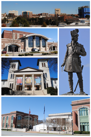
Spartanburg is a city in and the seat of Spartanburg County, South Carolina, United States. The city had a population 38,732 as of the 2020 census, making it the 11th-largest city in the state. For a time, the Office of Management and Budget (OMB) grouped Spartanburg and Union Counties together as the Spartanburg metropolitan statistical area, but the OMB now defines the Spartanburg MSA as only Spartanburg County.

Highlands is an incorporated town in Macon County in the U.S. state of North Carolina. Located on a plateau in the southern Appalachian Mountains, within the Nantahala National Forest, it lies mostly in southeastern Macon County and slightly in southwestern Jackson County, in the Highlands and Cashiers Townships, respectively. The permanent population was 1,014 at the 2020 census.

Greer is a city in Greenville and Spartanburg counties in the U.S. state of South Carolina. The population was 35,308 as of the 2020 census. Greer is a principal city in the Greenville-Anderson-Greer, SC Metropolitan Statistical Area. The city is additionally part of the Greenville-Spartanburg-Anderson, SC Combined Statistical Area in Upstate South Carolina.

Bynum is an unincorporated community in northeastern Chatham County, North Carolina, United States on the banks of the Haw River. Bynum is five miles (8.0 km) north of Pittsboro and eleven miles (18 km) south of Chapel Hill. It is also known as Bynum Mill Village or Bynum Mill Hill.

U.S. Route 176 is a spur of US 76 in the U.S. states of North Carolina and South Carolina. The U.S. Highway runs 237.98 miles (382.99 km) from US 25 Business and North Carolina Highway 225 in Hendersonville, North Carolina, east to US 52 in Goose Creek, South Carolina. US 176 serves the transition region between the Blue Ridge Mountains and Foothills of Western North Carolina and the Upstate, Midlands, and Lowcountry regions of South Carolina. The highway passes through and connects Spartanburg, one of two major cities in the Upstate, and Columbia, the South Carolina state capital and central city of the Midlands. US 176 parallels and serves as a secondary highway to Interstate 26 (I-26) except for between Spartanburg and Columbia, where the U.S. Highway deviates from the I-26 corridor to serve Union.

The Upstate is the region in the westernmost part of South Carolina, United States, also known as the Upcountry, which is the historical term. Although loosely defined among locals, the general definition includes the 10 counties of the commerce-rich I-85 corridor in the northwest corner of South Carolina. This definition coincided with the Greenville–Spartanburg–Anderson, SC combined statistical area, as first defined by the Office of Management and Budget (OMB) in 2015. In 2023, the OMB issued its most updated definition of the CSA that coincides again with the 10-county region.

The 5th congressional district of South Carolina is a congressional district in northern South Carolina bordering North Carolina. The district includes all of Cherokee, Chester, Fairfield, Kershaw, Lancaster, Lee, Union and York counties and parts of Newberry, Spartanburg and Sumter counties. Outside the rapidly growing cities of Rock Hill, Fort Mill, and Lake Wylie the district is mostly rural and agricultural. The district borders were contracted from some of the easternmost counties in the 2012 redistricting.
Spartanburg Regional Healthcare System(SRHS) is one of South Carolina's largest healthcare systems. SRHS draws patients primarily from the areas of Spartanburg, Cherokee, Union, and Greenville counties, located in the Piedmont region of South Carolina, and Rutherford and Polk counties, located in western North Carolina. Spartanburg General Hospital was organized under the authority of the South Carolina General Assembly in 1917 and officially became the Spartanburg Regional Health Services District, Inc., a political subdivision of the State of South Carolina, by the charter granted by the secretary of state of South Carolina on May 1, 1995.
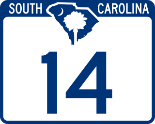
South Carolina Highway 14 is a state highway in the U.S. state of South Carolina. The state highway runs 59.24 miles (95.34 km) from U.S. Route 76 Business in Laurens north to Interstate 26 (I-26) in Landrum. SC 14 connects Laurens and Landrum with Greer, the city between Greenville and Spartanburg where the highway crosses I-85 and US 29. The highway also parallels I-385 through Fountain Inn and Simpsonville, South Carolina in southeastern Greenville County. SC 14 is a part of the National Highway System between I-85 and US 29 in Greer.
Spartanburg County School District 2 is a public school district in Spartanburg County, South Carolina, US. The district is Led by superintendent Lance Radford and consists of 14 schools. The district also has a maintenance and transportation department to serve the students and staff. Students in the district have access to the Swofford Career Center- it is shared with Spartanburg County School District 1.

Halifax Media Group was an American newspaper company owning more than 30 newspapers in five Southeastern U.S. States. It was founded on March 31, 2010 when a group of investors purchased The Daytona Beach News-Journal from the Davidson family, who had owned it for 82 years. On December 27, 2011, The New York Times Company announced it was selling its Regional Media Group to Halifax Media Group. On June 1, 2012, Halifax announced it was acquiring the Florida and North Carolina papers of Freedom Communications. In 2013, Halifax acquired three newspapers from HarborPoint Media: the Daily Commercial of Leesburg, Florida, the South Lake Press in Clermont, Florida and News-Sun of Sebring, Florida. In 2014, Halifax acquired the Telegram & Gazette of Worcester, Massachusetts. In November 2014, New Media Investment Group announced its acquisition of Halifax. The company was created with the assistance of Stephens Inc.

Croft State Park is a state park in Spartanburg County, South Carolina, located on land used during World War II as Camp Croft, a US Army basic training center and prisoner-of-war camp.

Lake Bowen or Lake William C. Bowen is a 1,534-acre (621 ha) reservoir in northern Spartanburg County, South Carolina, 6 miles (10 km) from the North Carolina border. The Interstate 26 bridge crosses over Lake Bowen between exits 5 and 10 on Interstate 26. The lake stretches parallel to South Carolina Highway 11. It is the largest lake in Spartanburg County with 33 miles (53 km) of shoreline. The lake is formed by the waters of the South Pacolet River to serve as a public drinking water supply. Rules and regulations were adopted for recreational activities like boating and fishing. There are picnic pavilions, boat ramps, and a playground near the lake. Fish from the lake is safe to eat.

