Cleveland is an unincorporated community in Greenville County, South Carolina, United States. Cleveland is located on U.S. Route 276 and South Carolina Highway 11, 8.7 miles (14.0 km) north-northwest of Travelers Rest. Cleveland has a post office with ZIP code 29635, which opened on April 9, 1900.

Fork is an unincorporated community in Dillon County, South Carolina, United States. Fork is located at the junction of South Carolina Highway 41 and South Carolina Highway 57, 10.4 miles (16.7 km) south-southeast of Dillon. Fork has a post office with ZIP code 29543.

Willard is an unincorporated community in Pender County, North Carolina, United States. The community is located on North Carolina Highway 11 3.3 miles (5.3 km) south-southeast of Wallace. Willard has a post office with ZIP code 28478.

Gresham is an unincorporated community in Marion County, South Carolina, United States. The community is located north of the junction of U.S. Route 378 and South Carolina Highway 41, 17 miles (27 km) south of Marion. Gresham has a post office with ZIP code 29546, which opened on May 26, 1880.

Blair is an unincorporated community in Fairfield County, South Carolina, United States. The community is located near the Broad River at the county's western border, 18 miles (29 km) west of Winnsboro. Blair has a post office with ZIP code 29015.

Davis Station is an unincorporated community in Clarendon County, South Carolina, United States. The community is 7.1 miles (11.4 km) south-southwest of Manning. Davis Station has a post office with ZIP code 29041.

Elliott is an unincorporated community in Lee County, South Carolina, United States. The community is located at the junction of U.S. Route 401 and South Carolina Highway 527, 9 miles (14 km) south-southeast of Bishopville. Elliott has a post office with ZIP code 29046, which opened on March 20, 1888.

Gable is an unincorporated community in Clarendon County, South Carolina, United States. The community is located along U.S. Route 301, 10.7 miles (17.2 km) north-northeast of Manning. Gable has a post office with ZIP code 29051, which opened on June 6, 1916.

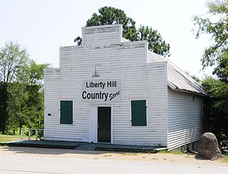
Liberty Hill is an unincorporated community in Kershaw County, South Carolina, United States. The community is located at the junction of South Carolina Highway 97 and South Carolina Highway 522, 19.5 miles (31.4 km) northwest of Camden. Liberty Hill has a post office with ZIP code 29074, which opened on January 19, 1818.

New Zion is an unincorporated community in Clarendon County, South Carolina, United States. The community is located along Pudding Swamp, 3.3 miles (5.3 km) south of Turbeville. New Zion has a post office with ZIP code 29111, which opened on March 25, 1852.

Rion is an unincorporated community in Fairfield County, South Carolina, United States. The community is located near South Carolina Highway 269 5.5 miles (8.9 km) south-southwest of Winnsboro. Rion has a post office with ZIP code 29132, which opened on July 15, 1884.

Sardinia is an unincorporated community in Clarendon County, South Carolina, United States. The community is located along U.S. Route 301, 5.4 miles (8.7 km) southwest of Turbeville. Sardinia has a post office with ZIP code 29143.

State Park is an unincorporated community in Richland County, South Carolina, United States. The community is located in a suburban area 7.3 miles (11.7 km) northeast of Columbia. State Park has a post office with ZIP code 29147.

Una is an unincorporated community in Spartanburg County, South Carolina, United States. The community is 2.5 miles (4.0 km) northwest of downtown Spartanburg. Una has a post office with ZIP code 29378, which opened on November 14, 1928.

Canadys is an unincorporated community in Colleton County, South Carolina, United States. The community is located at the intersection of U.S. Route 15 (US 15) and South Carolina Highway 61 (SC 61), 10.7 miles (17.2 km) north-northeast of Walterboro. Canadys had a post office from April 16, 1926 until January 11, 1992; it still has its own ZIP code, 29433.

Cordesville is an unincorporated community in Berkeley County, South Carolina, United States. The community is located on South Carolina Highway 402 8.7 miles (14.0 km) east-southeast of Moncks Corner. Cordesville has a post office with ZIP code 29434.

Pineville is an unincorporated community in Berkeley County, South Carolina, United States. The community is located on South Carolina Highway 45 6.3 miles (10.1 km) west-northwest of St. Stephen. Pineville has a post office with ZIP code 29468, which opened on March 19, 1880.

Ruffin is an unincorporated community in Colleton County, South Carolina, United States. The community is located on U.S. Route 21, 11 miles (18 km) northwest of Walterboro. Ruffin has a post office with ZIP code 29475, which opened on October 19, 1893.

Bowling Green is an unincorporated community in York County, South Carolina, United States. The community is located along U.S. Route 321, 2.7 miles (4.3 km) north-northeast of Clover. Bowling Green has a post office with ZIP code 29703.

Tillman is an unincorporated community in Jasper County, South Carolina, United States. The community is located at the intersection of U.S. Route 321 and South Carolina Highway 336, 7.5 miles (12.1 km) west of Ridgeland. Tillman has a post office with ZIP code 29943, which opened on August 2, 1880.


