U.S. Highway 178 is a spur of U.S. Highway 78. It currently runs for 240.49 miles (387.03 km) from Dorchester, South Carolina, at U.S. Highway 78 to Rosman, North Carolina, at U.S. Highway 64. It passes through the states of South Carolina and North Carolina. It goes through the cities of Pickens, Anderson, North crossing the highway 321, Orangeburg, Harleyville, South Carolina and Bowman, South Carolina.

U.S. Route 221 (US 221) is a part of the United States Numbered Highway System that runs from Perry in northern Florida to Lynchburg in central Virginia. In South Carolina, the highway runs north to south from the Georgia state line near Clarks Hill to the North Carolina state line near Chesnee. While in the state, the highway passes through Greenwood, Laurens, Woodruff, and Spartanburg. The highway mostly travels through rural parts of the Piedmont region of the state.

South Carolina Highway 97 (SC 97) is a state highway in the U.S. state of South Carolina. The highway connects Camden, Great Falls, Chester, and Hickory Grove.

South Carolina Highway 184 (SC 184) is a 34.4-mile-long (55.4 km) state highway in the U.S. state of South Carolina. The highway connects the Georgia state line and the Ware Shoals area, via Antreville, Due West, and Donalds.

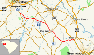
South Carolina Highway 185 (SC 185) is a 26.7-mile-long (43.0 km) state highway in the U.S. state of South Carolina. The highway connects Hodges and Due West with the Homeland Park area.
South Carolina Highway 187 (SC 187) is a 30.1-mile-long (48.4 km) state highway in the U.S. state of South Carolina. The highway travels through mostly rural areas of Anderson County.

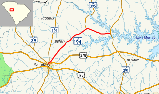
South Carolina Highway 194 (SC 194) is a 14.7-mile-long (23.7 km) state highway in the U.S. state of South Carolina. The highway connects Saluda and rural areas of Saluda County.

South Carolina Highway 252 (SC 252) is a 35.7-mile-long (57.5 km) state highway in the U.S. state of South Carolina. The highway connects the Anderson and Laurens areas with Honea Path and Ware Shoals. It has a unique feature in that it intersects U.S. Route 76 (US 76) three times along its length.
South Carolina Highway 267 (SC 267) is a 23.4-mile-long (37.7 km) state highway in the U.S. state of South Carolina. The highway connects the Santee area with rural areas of Orangeburg and Calhoun counties, via Elloree.

South Carolina Highway 283 (SC 283) is a 17.8-mile-long (28.6 km) state highway in the U.S. state of South Carolina. The highway connects Plum Branch with rural areas of McCormick and Edgefield counties.
South Carolina Highway 292 (SC 292) is a 13.4-mile-long (21.6 km) state highway in the U.S. state of South Carolina. The highway connects Duncan and the Inman area, via Lyman.
South Carolina Highway 322 (SC 322) is a 27.6-mile-long (44.4 km) state highway in the U.S. state of South Carolina. The highway travels through mostly rural areas of York County.
South Carolina Highway 391 (SC 391) is a 34.8-mile-long (56.0 km) state highway in the U.S. state of South Carolina. The highway connects rural areas of Aiken County with Prosperity, via Batesburg-Leesville.
South Carolina Highway 420 (SC 420) is a 4.9-mile-long (7.9 km) state highway in the U.S. state of South Carolina. The highway connects Shoals Junction and Ware Shoals.
South Carolina Highway 441 (SC 441) is a 26.3-mile-long (42.3 km) state highway in the U.S. state of South Carolina. The highway connects the Sumter area in Sumter County with rural areas of Lee County.
South Carolina Highway 908 (SC 908) is a 7.6-mile-long (12.2 km) state highway in the U.S. state of South Carolina. The highway connects rural areas of Marion County with Brittons Neck.
South Carolina Highway 912 (SC 912) is a 8.35-mile-long (13.44 km) state highway in the U.S. state of South Carolina. The highway travels through rural areas of Marlboro County. It functions like a western bypass of the city of Bennettsville.

South Carolina Highway 81 (SC 81) is a 80.6-mile-long (129.7 km) state highway in the U.S. state of South Carolina. The highway connects rural areas of McCormick County with Greenville, via Calhoun Falls, Iva, Homeland Park, and Anderson.

South Carolina Highway 113 (SC 113) is a 13.7-mile-long (22.0 km) state highway in the U.S. state of South Carolina. The highway connects rural areas of Aiken and Lexington counties with Wagener.
South Carolina Highway 302 (SC 302) is a 80.6-mile-long (129.7 km) state highway in the U.S. state of South Carolina. The highway travels through mostly rural areas of Aiken and Lexington counties and connects the Aiken with the Columbia metropolitan areas, via Wagener and Pelion.


