South Dakota Highway 65

Last updated

SD 65.svg

Highway 65

South Dakota Highway 65 map 1.png

Route of SD 65 (in red)
Route information
Defined by SDCL §31-4-174
Maintained by SDDOT
Length 70.485 mi [1] (113.435 km)
Existed 1926 – present
Major junctions
South endUS 212.svg US 212 east of Dupree
North endND-31 (2015).svg ND 31 at McIntosh
Location
Counties Ziebach, Dewey, Corson
Highway system
  • South Dakota Highways
SD 63.svg SD 63 SD 71 SD 71.svg

South Dakota Highway 65 (SD 65) is a state route in north-central region of the U.S. state of South Dakota. It begins at U.S. Highway 212 east of Dupree, then runs northerly to the North Dakota border near McIntosh, where it continues as North Dakota Highway 31. It is about 68 miles (109 km) in length.

U.S. state constituent political entity sharing sovereignty as the United States of America

In the United States, a state is a constituent political entity, of which there are currently 50. Bound together in a political union, each state holds governmental jurisdiction over a separate and defined geographic territory and shares its sovereignty with the federal government. Due to this shared sovereignty, Americans are citizens both of the federal republic and of the state in which they reside. State citizenship and residency are flexible, and no government approval is required to move between states, except for persons restricted by certain types of court orders. Four states use the term commonwealth rather than state in their full official names.

South Dakota State of the United States of America

South Dakota is a U.S. state in the Midwestern region of the United States. It is named after the Lakota and Dakota Sioux Native American tribes, who compose a large portion of the population and historically dominated the territory. South Dakota is the seventeenth largest by area, but the fifth smallest by population and the 5th least densely populated of the 50 United States. As the southern part of the former Dakota Territory, South Dakota became a state on November 2, 1889, simultaneously with North Dakota. Pierre is the state capital and Sioux Falls, with a population of about 183,200, is South Dakota's largest city.

Dupree, South Dakota City in South Dakota, United States

Dupree is a city in Ziebach County, South Dakota, United States. The population was 525 at the 2010 census. It is the county seat of Ziebach County, and the only incorporated community located fully within its borders.

Contents

History

When first designated in the 1920s, South Dakota 65 consisted of three segments, one stretching from the North Dakota border to the Grand River, one from an intersection with South Dakota Highway 18 in Isabel to an intersection with US 212 in Dupree, and the final segment stretching from US 16 in Kadoka to the Nebraska border south of Martin.

North Dakota State of the United States of America

North Dakota is a U.S. state in the midwestern and northern regions of the United States. It is the nineteenth largest in area, the fourth smallest by population, and the fourth most sparsely populated of the 50 states. North Dakota was admitted to the Union on November 2, 1889, along with its neighboring state, South Dakota. Its capital is Bismarck, and its largest city is Fargo.

Isabel, South Dakota Town in South Dakota, United States

Isabel is a town in Dewey County, South Dakota, United States. The population was 135 at the 2010 census.

U.S. Route 16 highway in the United States

U.S. Route 16 (US 16) is an east–west United States Highway between Rapid City, South Dakota and Yellowstone National Park in Wyoming.

Construction of a new road led to the connection of the two northern segments by 1932. The segment south of US 16 was re-designated as an extension of South Dakota Highway 63 in 1929.

South Dakota Highway 63 (SD 63) is a 167.455-mile-long (269.493 km) state highway in the central portions of the U.S. state of South Dakota. It connects U.S. Route 18 (US 18) south-southeast of Parmelee with the North Dakota state line north of McLaughlin.

Major intersections

CountyLocationmi [1] kmDestinationsNotes
Ziebach 0.0000.000US 212.svg US 212  Dupree, Eagle Butte
ZiebachDewey
county line
25.19040.539SD 20.svg SD 20 west Glad Valley Southern end of SD 20 concurrency
Dewey Isabel 28.67046.140SD 20.svg SD 20 east Timber Lake Northern end of SD 20 concurrency
Corson 66.054106.304US 12.svg US 12 east McLaughlin Southern end of US 12 concurrency
69.560111.946US 12.svg US 12 west Lemmon Northern end of US 12 concurrency
70.845114.014ND-31 (2015).svg ND 31 north Raleigh, Mandan Continuation into North Dakota
1.000 mi = 1.609 km; 1.000 km = 0.621 mi

The route of SD 65 is defined in South Dakota Codified Laws § 31-4-174. [2]

Related Research Articles

U.S. Route 212 (US 212) is a spur of U.S. Route 12. It does not intersect U.S. 12 now, but it once had an eastern terminus at U.S. 12 in St. Paul, Minnesota. It runs for 949 miles (1,527 km) from Minnesota Highway 62 at Edina, Minnesota to Yellowstone National Park.

Interstate 190 (I-190) is an auxiliary Interstate Highway in the U.S. state of South Dakota. The route runs for about 2 miles (3.2 km) connecting I-90 to downtown Rapid City. Its length from I-90 to Omaha Street runs concurrent with US 16. It is the westernmost auxiliary route of I-90 and its only auxiliary route west of the Mississippi River.

U.S. Route 16A is a 36.971-mile-long (59.499 km) scenic United States highway. It is an alternate route for US 16. It splits from US 16 in the Black Hills of the southwestern part of the U.S. state of South Dakota. The highway's western terminus is an intersection with US 16, US 385, and South Dakota Highway 89 (SD 89) in Custer, South Dakota. The eastern terminus is at an interchange with US 16 called the Keystone Wye south of Rapid City, South Dakota. Portions of US 16A are known as the Iron Mountain Road.

South Dakota Highway 115 highway in South Dakota

South Dakota Highway 115 was created from the routing of US 77, "Old 77", when its alignment was moved west to become Interstate 29 around 1980 and SD 15's route from US 18 to Sioux Falls. SD 115 routes from its intersection with US 18 about 13 miles (21 km) south of Sioux Falls to Interstate 29 three miles west of Dell Rapids. It is about 40.5 miles (65.2 km) in length.

South Dakota Highway 43 highway in South Dakota

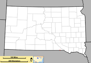
South Dakota Highway 43 (SD 43) is a 1.131-mile-long (1.820 km) state highway that exists entirely in the southern part of Gregory County in the southern part of the U.S. state of South Dakota. It begins as an extension of Nebraska Highway 11 (N-11) at the Nebraska state line south of Fairfax. It travels northwest to an intersection with U.S. Route 18 (US 18) south-southwest of the town.

South Dakota Highway 45 highway in South Dakota

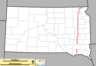
South Dakota Highway 45 is a state route that runs north to south across much of central South Dakota. The northern terminus is at the North Dakota border as a continuation of North Dakota Highway 3, and runs south to South Dakota Highway 44 at Platte. It is 198 miles (319 km) in length.

South Dakota Highway 47 highway in South Dakota

South Dakota Highway 47 is a state route that runs north to south across the central portion of South Dakota. It begins at an unnumbered highway at the North Dakota border north of Eureka, and ends at the Nebraska border, where it becomes Nebraska Highway 137. It is just under 241 miles (388 km) in length.

South Dakota Highway 22 highway in South Dakota

South Dakota Highway 22 (SD 22) is a 48.546-mile-long (78.127 km) state highway in the east-central part of the U.S. state of South Dakota. It connects Hazel, Castlewood, and Clear Lake, within the northern part of Hamlin County and the central part of Deuel County.

South Dakota Highway 53 highway in South Dakota

South Dakota Highway 53 is a state route that runs north to south across south central South Dakota. It consists of two separate segments:

South Dakota Highway 25 highway in South Dakota

South Dakota Highway 25 (SD 25) is a 194.524-mile-long (313.056 km) state highway in the eastern part of the U.S. state of South Dakota. It connects Scotland, Howard, De Smet, and Webster.

South Dakota Highway 15 highway in South Dakota

South Dakota Highway 15 (SD 15) is a 67.562-mile-long (108.730 km) state highway in the northeastern part of the U.S. state of South Dakota. It connects Clear Lake, Milbank, and Wilmot.

South Dakota Highway 50 highway in South Dakota

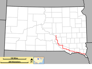
South Dakota Highway 50 is a state route serving south central and southeast South Dakota. The current alignment begins at the junction of South Dakota Highway 34 at "Lee's Corner" east of Fort Thompson, and ends at the Iowa border near Richland, where it continues as Iowa Highway 3. It is about 212 miles (341 km) in length.

South Dakota Highway 26 highway in South Dakota

South Dakota Highway 26 (SD 26) is a 49.540-mile-long (79.727 km) state highway in the central part of the U.S. state of South Dakota. It connects rural areas of Hyde, Hand, and Spink counties.

South Dakota Highway 73 highway in South Dakota

South Dakota Highway 73 is a state route that runs across western South Dakota. It begins at the Nebraska border north of Merriman, Nebraska, as a continuation of Nebraska Highway 61. It runs to the North Dakota border, where it continues as North Dakota Highway 49. It is just more than 255 miles (410 km) in length.

South Dakota Highway 11 highway in South Dakota

South Dakota Highway 11 (SD 11) is a 77.724-mile-long (125.085 km) state highway in the eastern part of the U.S. state of South Dakota. It connects the northern part of the Sioux City metropolitan area with the Sioux Falls metropolitan area.

South Dakota Highway 37 highway in South Dakota

South Dakota Highway 37 is a state route that runs across eastern South Dakota. It begins at the Nebraska border northeast of Niobrara, Nebraska, as a continuation of Nebraska Highway 14. It runs to the North Dakota border north of Hecla, where it continues as North Dakota Highway 1. It is 242 miles (389 km) in length.

Interstate 29 (I-29) is a north–south Interstate Highway in the midwestern United States. In the U.S. state of South Dakota, I-29 traverses on the eastern side of the state from the Iowa border near Sioux City to the North Dakota border near New Effington. On its route, I-29 passes through western portions of Sioux Falls, the state's largest city. Interstate 229, the highway's lone auxiliary route in South Dakota, serves as a bypass around southern and eastern Sioux Falls.

South Dakota Highway 40 highway in South Dakota

South Dakota Highway 40 (SD 40) is a state highway in southwest South Dakota. The highway is just over 37 miles (60 km) long and runs from U.S. Route 16A (US 16A) in Keystone to Bureau of Indian Affairs Highway 41 in Red Shirt. The highway runs near Mount Rushmore National Memorial in Keystone, and its eastern terminus is on the Pine Ridge Indian Reservation near the edge of Badlands National Park. SD 40 was established along its current route in 1976; the SD 40 designation was originally used on a highway that is now part of SD 44.

References

  1. 1 2 "Pierre Region Highway Log" (PDF). South Dakota Department of Transportation. February 9, 2017. pp. 5, 63–64. Retrieved January 11, 2018.
  2. "South Dakota Codified Law" . Retrieved November 4, 2012.

Route map: Google

KML file (edithelp)
KML is from Wikidata