Allen is a census-designated place on the Pine Ridge Indian Reservation in Bennett County, South Dakota, United States, that was named for the Allen Township, which it encompasses. As of the 2020 census, the CDP had a population of 460. It is one of two places which are closest to the North American continental pole of inaccessibility.
Bullhead is a census-designated place (CDP) in Corson County, South Dakota, United States, within the Standing Rock Indian Reservation. The population was 348 at the 2010 census.

North Eagle Butte is a census-designated place (CDP) in Dewey County, South Dakota, United States, along the 45th parallel. The population was 1,879 at the 2020 census.

Wanblee is a census-designated place on the Pine Ridge Indian Reservation, located in Jackson County, South Dakota, United States. The population was 674 at the 2020 census, virtually all of whom are members of the Oglala band of Lakota Sioux. Wanbli is the Lakota word for eagle, and the town was named for its proximity to Wanbli hohpi paha. Wanblee is a few miles directly northeast of the North American continental pole of inaccessibility.

Vivian is an unincorporated community and census-designated place (CDP) in Lyman County, South Dakota, United States. The population was 98 at the 2020 census.

Kyle is a census-designated place (CDP) in Oglala Lakota County, South Dakota, United States. Its population was 943 at the 2020 census. Located within the Pine Ridge Indian Reservation of the Oglala Lakota, it is one of two settlements which are closest to the North American continental pole of inaccessibility.

Oglala is a census-designated place (CDP) in West Oglala Lakota Unorganized Territory equivalent, Oglala Lakota County, South Dakota, United States. The population was 1,282 at the 2020 census. Its location is in the northwest of the Pine Ridge Indian Reservation.
Union Center is a small rural village in Meade County, South Dakota, United States. It is an unincorporated community, which was designated as part of the U.S. Census Bureau's Participant Statistical Areas Program on June 10, 2010. It was not counted separately during the 2000 Census, but is scheduled for inclusion in the 2010 Census. It has the post office which serves the area covered by ZIP code 57787, and three small businesses.

Nash is a census-designated place and unincorporated community in Walsh County, North Dakota, United States. Its population was 32 as of the 2010 census. The unincorporated community is located in Farmington Township, northwest of Grafton.
Shindler is an unincorporated community and census-designated place (CDP) in Lincoln County, South Dakota, United States. The population was 607 at the 2020 census.

Menoken is an unincorporated community and a census-designated place (CDP) in southwestern Burleigh County, North Dakota, United States. It was designated as part of the U.S. Census Bureau's Participant Statistical Areas Program on June 10, 2010. It was not counted separately during the 2000 Census, but was included in the 2010 Census, where a population of 70 was reported.

Sutton is a census-designated place in western Griggs County, North Dakota, United States. An unincorporated community, it was designated as part of the U.S. Census Bureau's Participant Statistical Areas Program on March 31, 2010. It was not counted separately during the 2000 Census, but was included in the 2010 Census, where a population of 17 was reported.

Spiritwood is a census-designated place (CDP) in eastern Stutsman County, North Dakota, United States. An unincorporated community, it was designated as part of the U.S. Census Bureau's Participant Statistical Areas Program on March 31, 2010. It was not counted separately during the 2000 census, but was included in the 2010 census, where a population of 18 was reported.

Porcupine is a census-designated place in Sioux County, North Dakota, United States. It lies only a few minutes' drive from the city of Selfridge. The community includes the headquarters of the Selfridge/Porcupine district.
Curlew Township is a former township in Morton County, North Dakota, United States. It was located near Glen Ullin, North Dakota.
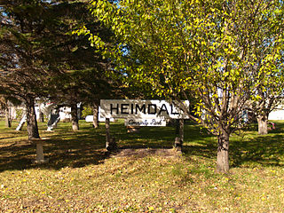
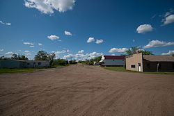
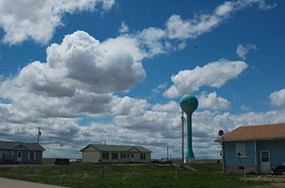
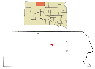
Heimdal is a census-designated place and unincorporated community in Wells County, North Dakota, United States. Its population was 16 as of the 2020 census.

Caln is a census-designated place (CDP) in Caln Township, Chester County, Pennsylvania, United States. The population was 1,519 at the 2010 census. It is located east of the city of Coatesville and lies west of Philadelphia.
Goodwill is an unincorporated community and former census-designated place (CDP) in Roberts County, South Dakota, United States. Prior to the 2020 Census, the CDP was merged into the Agency Village census-designated place. Over 90% of the population is Native American.
Raleigh is a census-designated place (CDP) in Levy County, Florida, United States. The population was 373 at the 2010 census.
Lake Holm is a census-designated place (CDP) in King County, Washington, United States. The population was 3,221 at the 2010 census.